
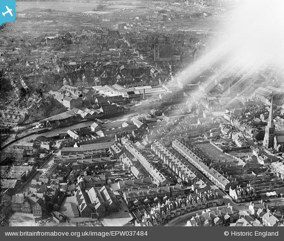
EPW037484 ENGLAND (1932). The Seven Bridges Brewery and Malthouses alongside the River Kennet, housing surrounding Henry Street and the town, Reading, 1932. This image has been affected by flare.
© Hawlfraint cyfranwyr OpenStreetMap a thrwyddedwyd gan yr OpenStreetMap Foundation. 2026. Trwyddedir y gartograffeg fel CC BY-SA.
Delweddau cyfagos (17)
EPW037484

EPW037026

EPW037029

EPW037486

EPW037481

EPW037485

EPW037487

EPW037482

EPW037031

EPW037495

EPW037483

EPW037030

EPW037027

EPW037488

EPW037028

EPW037489

EAW015081

Manylion
| Pennawd | [EPW037484] The Seven Bridges Brewery and Malthouses alongside the River Kennet, housing surrounding Henry Street and the town, Reading, 1932. This image has been affected by flare. |
| Cyfeirnod | EPW037484 |
| Dyddiad | April-1932 |
| Dolen | |
| Enw lle | READING |
| Plwyf | |
| Ardal | |
| Gwlad | ENGLAND |
| Dwyreiniad / Gogleddiad | 471455, 173023 |
| Hydred / Lledred | -0.97156516092549, 51.451187767737 |
| Cyfeirnod Grid Cenedlaethol | SU715730 |
Pinnau
Byddwch y cyntaf i ychwanegu sylw at y ddelwedd hon!