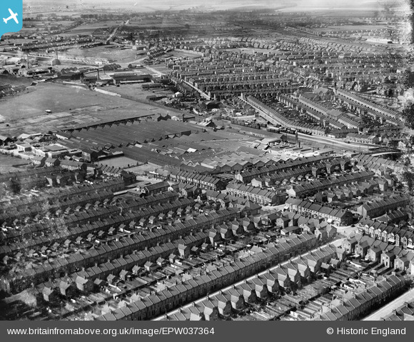
EPW037364 ENGLAND (1932). The Davis Gas Stove Co Diamond Foundry and surrounding housing, Luton, 1932
© Hawlfraint cyfranwyr OpenStreetMap a thrwyddedwyd gan yr OpenStreetMap Foundation. 2026. Trwyddedir y gartograffeg fel CC BY-SA.
Delweddau cyfagos (13)
Manylion
| Pennawd | [EPW037364] The Davis Gas Stove Co Diamond Foundry and surrounding housing, Luton, 1932 |
| Cyfeirnod | EPW037364 |
| Dyddiad | 13-April-1932 |
| Dolen | |
| Enw lle | LUTON |
| Plwyf | |
| Ardal | |
| Gwlad | ENGLAND |
| Dwyreiniad / Gogleddiad | 507789, 221676 |
| Hydred / Lledred | -0.43377917325688, 51.882774110052 |
| Cyfeirnod Grid Cenedlaethol | TL078217 |


![[EPW037364] The Davis Gas Stove Co Diamond Foundry and surrounding housing, Luton, 1932](http://britainfromabove.org.uk/sites/all/libraries/aerofilms-images/public/100x100/EPW/037/EPW037364.jpg)
![[EPW037363] The Davis Gas Stove Co Diamond Foundry and surrounding housing, Luton, 1932](http://britainfromabove.org.uk/sites/all/libraries/aerofilms-images/public/100x100/EPW/037/EPW037363.jpg)
![[EPW037362] The Davis Gas Stove Co Diamond Foundry and surrounding housing, Luton, 1932](http://britainfromabove.org.uk/sites/all/libraries/aerofilms-images/public/100x100/EPW/037/EPW037362.jpg)
![[EPW037357] The Davis Gas Stove Co Diamond Foundry and surrounding housing, Luton, 1932](http://britainfromabove.org.uk/sites/all/libraries/aerofilms-images/public/100x100/EPW/037/EPW037357.jpg)
![[EPW037360] The Davis Gas Stove Co Diamond Foundry and surrounding housing, Luton, 1932](http://britainfromabove.org.uk/sites/all/libraries/aerofilms-images/public/100x100/EPW/037/EPW037360.jpg)
![[EPW037358] The Davis Gas Stove Co Diamond Foundry and surrounding housing, Luton, 1932](http://britainfromabove.org.uk/sites/all/libraries/aerofilms-images/public/100x100/EPW/037/EPW037358.jpg)
![[EPW037359] The Davis Gas Stove Co Diamond Foundry and surrounding housing, Luton, 1932](http://britainfromabove.org.uk/sites/all/libraries/aerofilms-images/public/100x100/EPW/037/EPW037359.jpg)
![[EPW037361] The Davis Gas Stove Co Diamond Foundry and surrounding housing, Luton, 1932](http://britainfromabove.org.uk/sites/all/libraries/aerofilms-images/public/100x100/EPW/037/EPW037361.jpg)
![[EPW037365] The Davis Gas Stove Co Diamond Foundry, Dallow Road and surrounding housing, Luton, 1932](http://britainfromabove.org.uk/sites/all/libraries/aerofilms-images/public/100x100/EPW/037/EPW037365.jpg)
![[EPW037366] The Davis Gas Stove Co Diamond Foundry, Dallow Road and Kenilworth Football Ground in the background, Luton, 1932](http://britainfromabove.org.uk/sites/all/libraries/aerofilms-images/public/100x100/EPW/037/EPW037366.jpg)
![[EPW061315] Winsdon Hill, Bury Park and Biscot, Luton, from the south-west, 1939](http://britainfromabove.org.uk/sites/all/libraries/aerofilms-images/public/100x100/EPW/061/EPW061315.jpg)
![[EPW019307] Luton Town Football Ground, Luton, 1927](http://britainfromabove.org.uk/sites/all/libraries/aerofilms-images/public/100x100/EPW/019/EPW019307.jpg)
![[EAW016042] The town, Luton, from the north-west, 1948. This image has been produced from a print.](http://britainfromabove.org.uk/sites/all/libraries/aerofilms-images/public/100x100/EAW/016/EAW016042.jpg)
