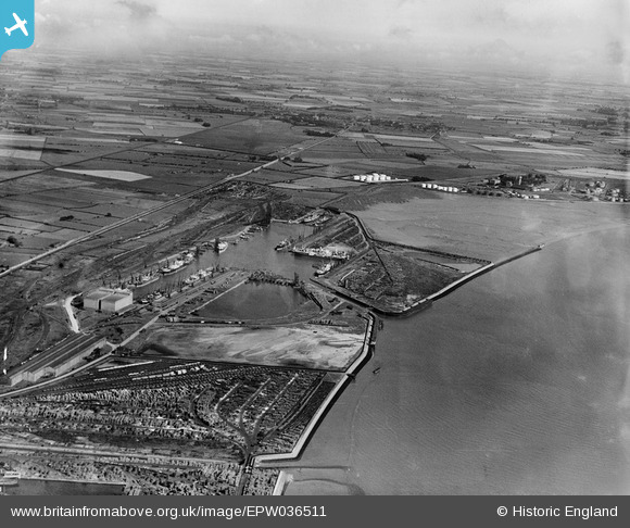
EPW036511 ENGLAND (1931). The King George Dock, Kingston upon Hull, from the south-west, 1931
    © Hawlfraint cyfranwyr OpenStreetMap a thrwyddedwyd gan yr OpenStreetMap Foundation. 2025. Trwyddedir y gartograffeg fel CC BY-SA.
  
Delweddau cyfagos (5)
Manylion
| Pennawd | [EPW036511] The King George Dock, Kingston upon Hull, from the south-west, 1931 | 
| Cyfeirnod | EPW036511 | 
| Dyddiad | August-1931 | 
| Dolen | |
| Enw lle | KINGSTON UPON HULL | 
| Plwyf | |
| Ardal | |
| Gwlad | ENGLAND | 
| Dwyreiniad / Gogleddiad | 514561, 428635 | 
| Hydred / Lledred | -0.26280440451907, 53.741269646819 | 
| Cyfeirnod Grid Cenedlaethol | TA146286 | 
Pinnau
Byddwch y cyntaf i ychwanegu sylw at y ddelwedd hon!
 
             
  ![[EPW036511] The King George Dock, Kingston upon Hull, from the south-west, 1931](http://britainfromabove.org.uk/sites/all/libraries/aerofilms-images/public/100x100/EPW/036/EPW036511.jpg) 
  
                                          ![[EPW009395] The King George Dock, Kingston upon Hull, 1923](http://britainfromabove.org.uk/sites/all/libraries/aerofilms-images/public/100x100/EPW/009/EPW009395.jpg) 
 ![[EAW015663] King George Dock, Great Field and environs, Marfleet, from the south, 1948. This image has been produced from a print.](http://britainfromabove.org.uk/sites/all/libraries/aerofilms-images/public/100x100/EAW/015/EAW015663.jpg) 
 ![[EPW010820] King George Dock, Kingston upon Hull, 1924. This image has been produced from a damaged print.](http://britainfromabove.org.uk/sites/all/libraries/aerofilms-images/public/100x100/EPW/010/EPW010820.jpg) 
 ![[EPW036390] The King George Dock and environs, Kingston upon Hull, 1931](http://britainfromabove.org.uk/sites/all/libraries/aerofilms-images/public/100x100/EPW/036/EPW036390.jpg)