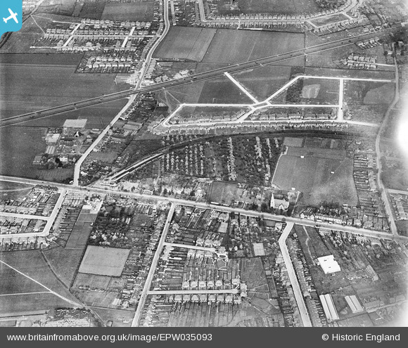
EPW035093 ENGLAND (1931). Residential development around Hounslow West Station, Hounslow West, 1931
© Hawlfraint cyfranwyr OpenStreetMap a thrwyddedwyd gan yr OpenStreetMap Foundation. 2026. Trwyddedir y gartograffeg fel CC BY-SA.
Delweddau cyfagos (15)
Manylion
| Pennawd | [EPW035093] Residential development around Hounslow West Station, Hounslow West, 1931 |
| Cyfeirnod | EPW035093 |
| Dyddiad | May-1931 |
| Dolen | |
| Enw lle | HOUNSLOW WEST |
| Plwyf | |
| Ardal | |
| Gwlad | ENGLAND |
| Dwyreiniad / Gogleddiad | 512414, 176160 |
| Hydred / Lledred | -0.38126118236632, 51.472735066525 |
| Cyfeirnod Grid Cenedlaethol | TQ124762 |
Pinnau

Des Elmes |
Thursday 9th of January 2025 08:26:00 PM | |

Des Elmes |
Thursday 9th of January 2025 08:24:28 PM | |

Des Elmes |
Thursday 9th of January 2025 08:23:34 PM | |

Des Elmes |
Thursday 9th of January 2025 08:21:17 PM | |

Des Elmes |
Thursday 9th of January 2025 08:19:26 PM | |

Des Elmes |
Thursday 9th of January 2025 08:18:51 PM | |

glennsalt@gmail.com |
Sunday 4th of September 2016 08:00:40 AM | |

glennsalt@gmail.com |
Sunday 4th of September 2016 07:59:47 AM |
Cyfraniadau Grŵp
if anyone knows of an image that continues towards the east (centres on Bath Road, Sutton Lane, Wellington Road North junction) I would be pleased to know about it. This misses my childhood home by a few feet! |

Susanc241 |
Friday 7th of March 2014 09:52:12 AM |


![[EPW035093] Residential development around Hounslow West Station, Hounslow West, 1931](http://britainfromabove.org.uk/sites/all/libraries/aerofilms-images/public/100x100/EPW/035/EPW035093.jpg)
![[EPW033774] Houses and St Paul's Church with Heston Air Park in the distance, Hounslow West, from the south-east, 1930. This image has been produced from a damaged negative](http://britainfromabove.org.uk/sites/all/libraries/aerofilms-images/public/100x100/EPW/033/EPW033774.jpg)
![[EPW016529] Bath Road and Hounslow West Station, Hounslow, 1926](http://britainfromabove.org.uk/sites/all/libraries/aerofilms-images/public/100x100/EPW/016/EPW016529.jpg)
![[EPW016527] Bath Road, Hounslow, 1926](http://britainfromabove.org.uk/sites/all/libraries/aerofilms-images/public/100x100/EPW/016/EPW016527.jpg)
![[EPW035032] The Metropolitan and District Line and Hounslow, Heston, from the north-west, 1931](http://britainfromabove.org.uk/sites/all/libraries/aerofilms-images/public/100x100/EPW/035/EPW035032.jpg)
![[EPW035078] Residential development near Hounslow West Station, Hounslow West, 1931](http://britainfromabove.org.uk/sites/all/libraries/aerofilms-images/public/100x100/EPW/035/EPW035078.jpg)
![[EPW016528] Bath Road and Hounslow West Station, Hounslow, 1926](http://britainfromabove.org.uk/sites/all/libraries/aerofilms-images/public/100x100/EPW/016/EPW016528.jpg)
![[EPW037519] "The Earl Haigh" public house opposite Hounslow West Station, Hounslow, 1932](http://britainfromabove.org.uk/sites/all/libraries/aerofilms-images/public/100x100/EPW/037/EPW037519.jpg)
![[EPW037517] "The Earl Haigh" public house opposite Hounslow West Station, Hounslow, 1932](http://britainfromabove.org.uk/sites/all/libraries/aerofilms-images/public/100x100/EPW/037/EPW037517.jpg)
![[EPW037334] The Earl Haig Pub off Bath Road, Hounslow West, 1932. This image has been produced from a copy-negative.](http://britainfromabove.org.uk/sites/all/libraries/aerofilms-images/public/100x100/EPW/037/EPW037334.jpg)
![[EPW037518] "The Earl Haigh" public house opposite Hounslow West Station, Hounslow, 1932](http://britainfromabove.org.uk/sites/all/libraries/aerofilms-images/public/100x100/EPW/037/EPW037518.jpg)
![[EPW037296] Hounslow West Station, Bath Road and environs, Hounslow West, 1932. This image has been produced from a copy-negative.](http://britainfromabove.org.uk/sites/all/libraries/aerofilms-images/public/100x100/EPW/037/EPW037296.jpg)
![[EPW035079] Vicarage Farm, Hounslow West Station and environs, Hounslow West, 1931](http://britainfromabove.org.uk/sites/all/libraries/aerofilms-images/public/100x100/EPW/035/EPW035079.jpg)
![[EPW037332] Houses and gardens opposite Hounslow West Station, Hounslow, 1932](http://britainfromabove.org.uk/sites/all/libraries/aerofilms-images/public/100x100/EPW/037/EPW037332.jpg)
![[EPW037294] Looking over Heston, Hounslow West, from the south, 1932. This image has been produced from a copy-negative.](http://britainfromabove.org.uk/sites/all/libraries/aerofilms-images/public/100x100/EPW/037/EPW037294.jpg)