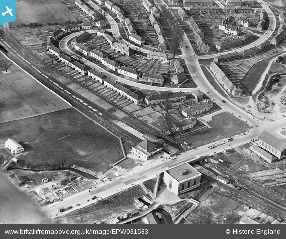
EPW031583 ENGLAND (1930). Burnt Oak Railway Station and Blessbury Road, Burnt Oak, 1930
© Hawlfraint cyfranwyr OpenStreetMap a thrwyddedwyd gan yr OpenStreetMap Foundation. 2026. Trwyddedir y gartograffeg fel CC BY-SA.
Delweddau cyfagos (23)
Manylion
| Pennawd | [EPW031583] Burnt Oak Railway Station and Blessbury Road, Burnt Oak, 1930 |
| Cyfeirnod | EPW031583 |
| Dyddiad | February-1930 |
| Dolen | |
| Enw lle | BURNT OAK |
| Plwyf | |
| Ardal | |
| Gwlad | ENGLAND |
| Dwyreiniad / Gogleddiad | 520295, 190813 |
| Hydred / Lledred | -0.26282217337715, 51.602819977544 |
| Cyfeirnod Grid Cenedlaethol | TQ203908 |
Pinnau

Airwick |
Sunday 12th of March 2023 08:12:25 PM | |

AndrewGVT |
Saturday 22nd of March 2014 10:48:57 AM | |

bazouteast |
Tuesday 18th of March 2014 09:33:40 PM | |

colsouth111 |
Wednesday 7th of August 2013 11:54:31 AM | |

colsouth111 |
Wednesday 7th of August 2013 11:46:07 AM |
Cyfraniadau Grŵp

colsouth111 |
Wednesday 7th of August 2013 11:56:48 AM |


![[EPW031583] Burnt Oak Railway Station and Blessbury Road, Burnt Oak, 1930](http://britainfromabove.org.uk/sites/all/libraries/aerofilms-images/public/100x100/EPW/031/EPW031583.jpg)
![[EPW031548] Burnt Oak Railway Station, Silkstream Park and surroundings, Burnt Oak, from the north-west, 1930](http://britainfromabove.org.uk/sites/all/libraries/aerofilms-images/public/100x100/EPW/031/EPW031548.jpg)
![[EPW031549] Burnt Oak Railway Station and environs, Burnt Oak, 1930](http://britainfromabove.org.uk/sites/all/libraries/aerofilms-images/public/100x100/EPW/031/EPW031549.jpg)
![[EPW009363] Construction of the underground station, Burnt Oak, 1923. This image has been produced from a print.](http://britainfromabove.org.uk/sites/all/libraries/aerofilms-images/public/100x100/EPW/009/EPW009363.jpg)
![[EPW009347] Construction of the underground station, Burnt Oak, 1923](http://britainfromabove.org.uk/sites/all/libraries/aerofilms-images/public/100x100/EPW/009/EPW009347.jpg)
![[EPW009345] Construction of the underground station, Burnt Oak, 1923](http://britainfromabove.org.uk/sites/all/libraries/aerofilms-images/public/100x100/EPW/009/EPW009345.jpg)
![[EPW016519] The underground station and environs, Burnt Oak, 1926](http://britainfromabove.org.uk/sites/all/libraries/aerofilms-images/public/100x100/EPW/016/EPW016519.jpg)
![[EPW016517] The underground station, Burnt Oak, 1926](http://britainfromabove.org.uk/sites/all/libraries/aerofilms-images/public/100x100/EPW/016/EPW016517.jpg)
![[EPW009344] Construction of the underground station, Burnt Oak, 1923](http://britainfromabove.org.uk/sites/all/libraries/aerofilms-images/public/100x100/EPW/009/EPW009344.jpg)
![[EPW009682] Burnt Oak Railway Station under construction, Burnt Oak, 1923](http://britainfromabove.org.uk/sites/all/libraries/aerofilms-images/public/100x100/EPW/009/EPW009682.jpg)
![[EPW009346] Construction of the underground station, Burnt Oak, 1923](http://britainfromabove.org.uk/sites/all/libraries/aerofilms-images/public/100x100/EPW/009/EPW009346.jpg)
![[EPW034858] De Havilland DH80A Puss Moth G-ABGR in flight, Burnt Oak, from the south-west, 1931](http://britainfromabove.org.uk/sites/all/libraries/aerofilms-images/public/100x100/EPW/034/EPW034858.jpg)
![[EPW019192] Housing development along Watling Avenue, Burnt Oak, 1927](http://britainfromabove.org.uk/sites/all/libraries/aerofilms-images/public/100x100/EPW/019/EPW019192.jpg)
![[EPW035548] Burnt Oak Railway Station, Watling Avenue and Hendon Aerodrome, Burnt Oak, 1931](http://britainfromabove.org.uk/sites/all/libraries/aerofilms-images/public/100x100/EPW/035/EPW035548.jpg)
![[EPW031550] Burnt Oak Railway Station, Silkstream Park and Hendon Aerodrome, Burnt Oak 1930](http://britainfromabove.org.uk/sites/all/libraries/aerofilms-images/public/100x100/EPW/031/EPW031550.jpg)
![[EPW009355] A De Havilland DH.53 "Humming Bird" in flight, Burnt Oak, 1923](http://britainfromabove.org.uk/sites/all/libraries/aerofilms-images/public/100x100/EPW/009/EPW009355.jpg)
![[EPW019336] New housing next to the London Aerodrome, Burnt Oak, 1927](http://britainfromabove.org.uk/sites/all/libraries/aerofilms-images/public/100x100/EPW/019/EPW019336.jpg)
![[EPW001350] Hendon Union Workhouse, Burnt Oak, 1920](http://britainfromabove.org.uk/sites/all/libraries/aerofilms-images/public/100x100/EPW/001/EPW001350.jpg)
![[EPW016518] Housing under construction in the Gloucester Grove area, Burnt Oak, 1926](http://britainfromabove.org.uk/sites/all/libraries/aerofilms-images/public/100x100/EPW/016/EPW016518.jpg)
![[EPW019190] Watling Avenue, Burnt Oak, 1927](http://britainfromabove.org.uk/sites/all/libraries/aerofilms-images/public/100x100/EPW/019/EPW019190.jpg)
![[EPW035547] The Redhill County Hospital, Watling Park and Hendon Aerodrome, Burnt Oak, 1931](http://britainfromabove.org.uk/sites/all/libraries/aerofilms-images/public/100x100/EPW/035/EPW035547.jpg)
![[EPW019191] Barnfield Road, Burnt Oak, 1927](http://britainfromabove.org.uk/sites/all/libraries/aerofilms-images/public/100x100/EPW/019/EPW019191.jpg)
![[EPW019193] Barnfield Road and the Redhill Institution, Burnt Oak, 1927](http://britainfromabove.org.uk/sites/all/libraries/aerofilms-images/public/100x100/EPW/019/EPW019193.jpg)
