Prydain oddi Fry Cymraeg | English  Mewngofnod | Cofrestru
  • Hafan
  • Gwaddol
  • Ynghylch
  • Map
  • Orielau
  • Grwpiau
  • Cymorth
  • Gweithgaredd Diweddaraf
  • Saved Images

Pagination

  • Current page 1
  • Tudalen 2
  • Tudalen 3
  • Tudalen 4
  • Tudalen 5
  • Next page next
  • Last page last
[EPW024777] North Kensington from the White City Stadium, Shepherd's Bush, from the south-west, 1928
[EPW015610] Motor Works, hospital and Hendon Aerodrome, Colindale, 1926
[EPW005719] The Schweppes Mineral Water Factory, West Hendon, 1921. This image has been produced from a copy-negative.
[EPW008004] Three Bristol F.2b aircraft in flight including J6730, J6736 and E3505, Burnt Oak, 1922. This image has been produced from a copy-negative.
[EAW044759] The residential area at Little Stanmore and Belmont, Little Stanmore, 1952
[EAW020696] Burnt Oak and the northern end of RAF Hendon, Edgware, from the south-west, 1948
[EPW009356] A DH53 in flight over Bacon Lane and the Edgware Road, Little Stanmore, 1923
[EPW047553] The former works of De Havilland at Stag Lane and surrounding housing development, Queensbury, 1935

Pagination

  • Current page 1
  • Tudalen 2
  • Tudalen 3
  • Tudalen 4
  • Tudalen 5
  • Next page next
  • Last page last
colsouth111 added an image record to the groups Burnt Oak, on the Northern line. (Successor to the currently inactive "Burnt Oak and Environs"). - "I'm adding this one for the wealth of information added by…"
8 years yn ôl
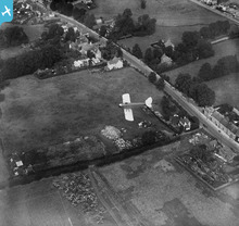
colsouth111 ychwanegodd bin at ddelwedd EPW013198 - "Burnt Oak Farm, the position of which approximates to the southern end of Axholme Ave."
8 years yn ôl
Cronfa Dreftadaeth y Loteri
Historic England
Historic Environment Scotland
Foyle Foundation
Comisiwn Brenhinol Henebion Cymru
Ynghylch y Prosiect | Prynu Delweddau | Cysylltu â Ni | Ymholiadau | Hygyrchedd | RhG a Chyfreithiol | Privacy Notice | Cwcis
© Historic Environment Scotland. Rhif elusen yr Alban SC045925.