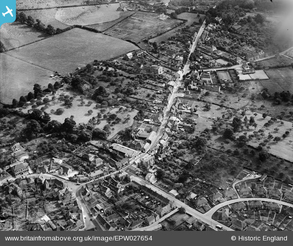
EPW027654 ENGLAND (1929). Warminster Road and surrounding countryside, Westbury, 1929
© Hawlfraint cyfranwyr OpenStreetMap a thrwyddedwyd gan yr OpenStreetMap Foundation. 2026. Trwyddedir y gartograffeg fel CC BY-SA.
Manylion
| Pennawd | [EPW027654] Warminster Road and surrounding countryside, Westbury, 1929 |
| Cyfeirnod | EPW027654 |
| Dyddiad | 21-June-1929 |
| Dolen | |
| Enw lle | WESTBURY |
| Plwyf | WESTBURY |
| Ardal | |
| Gwlad | ENGLAND |
| Dwyreiniad / Gogleddiad | 387220, 150987 |
| Hydred / Lledred | -2.1831629634734, 51.257391107069 |
| Cyfeirnod Grid Cenedlaethol | ST872510 |
Pinnau

alastair wallace |
Sunday 20th of December 2015 11:48:13 PM | |

alastair wallace |
Sunday 20th of December 2015 11:47:16 PM | |

speedbudgie |
Thursday 29th of May 2014 10:57:31 PM | |

mikes place |
Monday 11th of March 2013 12:39:01 PM | |

mikes place |
Monday 11th of March 2013 12:35:44 PM | |

Class31 |
Saturday 20th of October 2012 09:07:11 PM | |

Class31 |
Saturday 20th of October 2012 09:03:52 PM | |

Class31 |
Saturday 20th of October 2012 09:03:23 PM | |

Class31 |
Saturday 20th of October 2012 09:02:49 PM | |

Class31 |
Saturday 20th of October 2012 09:02:08 PM | |

Class31 |
Saturday 20th of October 2012 09:01:49 PM | |

Class31 |
Saturday 20th of October 2012 09:00:26 PM | |

Class31 |
Saturday 20th of October 2012 09:00:06 PM |
Cyfraniadau Grŵp
Highlighted the wrong brewery - sorry. This isn't Meade's Oak Brewery but another one, possibly Bartletts but not sure. |

alastair wallace |
Thursday 5th of November 2015 10:34:06 PM |


![[EPW027654] Warminster Road and surrounding countryside, Westbury, 1929](http://britainfromabove.org.uk/sites/all/libraries/aerofilms-images/public/100x100/EPW/027/EPW027654.jpg)
![[EPW027650] Haynes Road and the town centre, Westbury, 1929](http://britainfromabove.org.uk/sites/all/libraries/aerofilms-images/public/100x100/EPW/027/EPW027650.jpg)
![[EPW027645] The town, Westbury, 1929. This image has been produced from a copy-negative.](http://britainfromabove.org.uk/sites/all/libraries/aerofilms-images/public/100x100/EPW/027/EPW027645.jpg)