
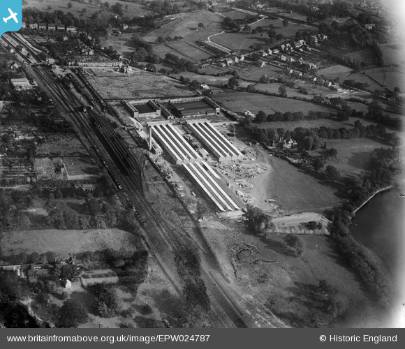
EPW024787 ENGLAND (1928). The Triplex Glass Works, Kings Norton, 1928
© Hawlfraint cyfranwyr OpenStreetMap a thrwyddedwyd gan yr OpenStreetMap Foundation. 2026. Trwyddedir y gartograffeg fel CC BY-SA.
Delweddau cyfagos (18)
EPW024787

EPW024784

EPW026964

EPW024793

EPW024794

EPW024783

EPW024795

EPW026963

EPW024786

EPW024789

EPW024781

EPW024790

EPW024769

EPW024785

EPW024792

EPW024788

EPW024791

EPW024782

Manylion
| Pennawd | [EPW024787] The Triplex Glass Works, Kings Norton, 1928 |
| Cyfeirnod | EPW024787 |
| Dyddiad | September-1928 |
| Dolen | |
| Enw lle | KINGS NORTON |
| Plwyf | |
| Ardal | |
| Gwlad | ENGLAND |
| Dwyreiniad / Gogleddiad | 404081, 279400 |
| Hydred / Lledred | -1.9399955833885, 52.412208083241 |
| Cyfeirnod Grid Cenedlaethol | SP041794 |
Pinnau

Ilwertornram4 |
Thursday 13th of February 2025 03:54:18 PM | |
|
Ilwertornram4 |
Thursday 13th of February 2025 03:41:21 PM | |
|
Griffin |
Tuesday 27th of October 2015 08:42:27 PM | |
|
Griffin |
Tuesday 27th of October 2015 08:29:44 PM | |
|
Griffin |
Tuesday 27th of October 2015 08:22:03 PM | |
|
Griffin |
Tuesday 27th of October 2015 08:18:48 PM | |
|
Mick |
Tuesday 26th of June 2012 07:57:41 PM |