
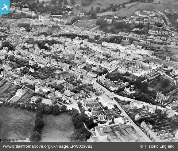
EPW023882 ENGLAND (1928). Holy Trinity Church, Middle Street and environs, Stroud, 1928
© Hawlfraint cyfranwyr OpenStreetMap a thrwyddedwyd gan yr OpenStreetMap Foundation. 2026. Trwyddedir y gartograffeg fel CC BY-SA.
Delweddau cyfagos (2)
EPW023882

EPW037757

Manylion
| Pennawd | [EPW023882] Holy Trinity Church, Middle Street and environs, Stroud, 1928 |
| Cyfeirnod | EPW023882 |
| Dyddiad | September-1928 |
| Dolen | |
| Enw lle | STROUD |
| Plwyf | STROUD |
| Ardal | |
| Gwlad | ENGLAND |
| Dwyreiniad / Gogleddiad | 385607, 205069 |
| Hydred / Lledred | -2.2084876311173, 51.743682198406 |
| Cyfeirnod Grid Cenedlaethol | SO856051 |
Pinnau

Synan |
Sunday 28th of February 2021 09:29:11 PM | |
|
Darren |
Sunday 12th of February 2017 10:40:27 PM | |
|
Darren |
Sunday 12th of February 2017 10:15:04 PM | |
|
Darren |
Sunday 12th of February 2017 10:12:36 PM | |
|
Darren |
Sunday 12th of February 2017 10:11:05 PM | |
|
Darren |
Sunday 12th of February 2017 10:07:50 PM | |
|
Darren |
Sunday 12th of February 2017 10:03:16 PM | |

Class31 |
Wednesday 17th of October 2012 12:57:01 PM | |
Parliament Street School - now the Register Office. |
JCB |
Thursday 17th of March 2016 02:32:16 PM |
|
Class31 |
Wednesday 17th of October 2012 12:55:41 PM | |
|
Class31 |
Wednesday 17th of October 2012 12:55:01 PM | |
|
Class31 |
Wednesday 17th of October 2012 12:54:24 PM | |
|
Class31 |
Wednesday 17th of October 2012 12:53:59 PM | |
|
Class31 |
Wednesday 17th of October 2012 12:53:43 PM | |
|
Class31 |
Wednesday 17th of October 2012 12:53:06 PM | |
|
Class31 |
Wednesday 17th of October 2012 12:52:29 PM | |
|
Class31 |
Wednesday 17th of October 2012 12:50:41 PM | |
The section from Acre Street into the town is Hill Street on a 1970 map but Parliament Street by the end of the 70s. This part is Tower Hill up to 1922, and Hill Street by 1936. East of Acre Street, it's shown as Parliament Street right back to 1884. (all from www.old-maps.co.uk) |
David960 |
Thursday 26th of February 2015 07:59:33 PM |
Thanks. For the details David960A response on my iphone |
Class31 |
Thursday 26th of February 2015 08:44:58 PM |
|
Paul |
Wednesday 27th of June 2012 05:01:22 PM |
Cyfraniadau Grŵp

A view over the Old Town |
cookie |
Wednesday 12th of February 2014 01:36:35 PM |