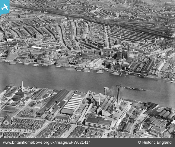
EPW021414 ENGLAND (1928). Price's Belmont Candle and Soap Works, the Sugar Works and environs, Battersea, 1928
© Hawlfraint cyfranwyr OpenStreetMap a thrwyddedwyd gan yr OpenStreetMap Foundation. 2026. Trwyddedir y gartograffeg fel CC BY-SA.
Delweddau cyfagos (26)
Manylion
| Pennawd | [EPW021414] Price's Belmont Candle and Soap Works, the Sugar Works and environs, Battersea, 1928 |
| Cyfeirnod | EPW021414 |
| Dyddiad | 30-May-1928 |
| Dolen | |
| Enw lle | BATTERSEA |
| Plwyf | |
| Ardal | |
| Gwlad | ENGLAND |
| Dwyreiniad / Gogleddiad | 526451, 175869 |
| Hydred / Lledred | -0.17933901783014, 51.467156042255 |
| Cyfeirnod Grid Cenedlaethol | TQ265759 |
Pinnau

Class31 |
Monday 4th of March 2013 02:48:54 PM | |

Class31 |
Monday 4th of March 2013 02:37:53 PM | |

Class31 |
Monday 4th of March 2013 02:33:57 PM | |

Class31 |
Monday 4th of March 2013 02:31:12 PM | |

Class31 |
Monday 4th of March 2013 02:28:29 PM | |

Class31 |
Monday 4th of March 2013 02:25:39 PM | |

Class31 |
Monday 4th of March 2013 02:23:12 PM |
Cyfraniadau Grŵp

The attached scan of an 1863 map shows Price's Candle Company Works on the edge of Battersea Creek. On the other side of the creek used to be a silk factory and behind that on the corner of York Place & York Road was a row of cottages called Ford's Buildings where my great great great grandfather lived in 1841. |

melgibbs |
Sunday 20th of April 2014 06:19:44 PM |


![[EPW021414] Price's Belmont Candle and Soap Works, the Sugar Works and environs, Battersea, 1928](http://britainfromabove.org.uk/sites/all/libraries/aerofilms-images/public/100x100/EPW/021/EPW021414.jpg)
![[EPW021410] Price's Belmont Candle and Soap Works and the Sugar Works at Southampton Wharf, Battersea, 1928](http://britainfromabove.org.uk/sites/all/libraries/aerofilms-images/public/100x100/EPW/021/EPW021410.jpg)
![[EPW041103] Garton Sons & Co Sugar Works and environs, Battersea, 1933](http://britainfromabove.org.uk/sites/all/libraries/aerofilms-images/public/100x100/EPW/041/EPW041103.jpg)
![[EPW021417] Price's Belmont Candle and Soap Works and the Sugar Works at Southampton Wharf, Battersea, 1928](http://britainfromabove.org.uk/sites/all/libraries/aerofilms-images/public/100x100/EPW/021/EPW021417.jpg)
![[EPW021415] Price's Belmont Candle and Soap Works, the Sugar Works and environs, Battersea, 1928](http://britainfromabove.org.uk/sites/all/libraries/aerofilms-images/public/100x100/EPW/021/EPW021415.jpg)
![[EPW041105] Garton Sons & Co Sugar Works, Battersea, 1933](http://britainfromabove.org.uk/sites/all/libraries/aerofilms-images/public/100x100/EPW/041/EPW041105.jpg)
![[EPW041102] Garton Sons & Co Sugar Works, Battersea, 1933](http://britainfromabove.org.uk/sites/all/libraries/aerofilms-images/public/100x100/EPW/041/EPW041102.jpg)
![[EPW021413] Price's Belmont Candle and Soap Works, Battersea, 1928](http://britainfromabove.org.uk/sites/all/libraries/aerofilms-images/public/100x100/EPW/021/EPW021413.jpg)
![[EPW021412] Price's Belmont Candle and Soap Works, Battersea, 1928](http://britainfromabove.org.uk/sites/all/libraries/aerofilms-images/public/100x100/EPW/021/EPW021412.jpg)
![[EPW021418] Price's Belmont Candle and Soap Works, Battersea, 1928](http://britainfromabove.org.uk/sites/all/libraries/aerofilms-images/public/100x100/EPW/021/EPW021418.jpg)
![[EPW041100] Garton Sons & Co Sugar Works and environs, Battersea, 1933](http://britainfromabove.org.uk/sites/all/libraries/aerofilms-images/public/100x100/EPW/041/EPW041100.jpg)
![[EPW021416] The Sugar Works at Southampton Wharf and environs, Battersea, 1928](http://britainfromabove.org.uk/sites/all/libraries/aerofilms-images/public/100x100/EPW/021/EPW021416.jpg)
![[EPW053655] The River Thames at Battersea Creek and environs, Battersea, 1937](http://britainfromabove.org.uk/sites/all/libraries/aerofilms-images/public/100x100/EPW/053/EPW053655.jpg)
![[EPW059341] Industry along the River Thames at Wandsworth Bridge and environs, Wandsworth, from the north-east, 1938](http://britainfromabove.org.uk/sites/all/libraries/aerofilms-images/public/100x100/EPW/059/EPW059341.jpg)
![[EPW041104] Garton Sons & Co Sugar Works, Battersea, 1933](http://britainfromabove.org.uk/sites/all/libraries/aerofilms-images/public/100x100/EPW/041/EPW041104.jpg)
![[EPW041106] Garton Sons & Co Sugar Works and environs, Battersea, 1933](http://britainfromabove.org.uk/sites/all/libraries/aerofilms-images/public/100x100/EPW/041/EPW041106.jpg)
![[EPW041107] Garton Sons & Co Sugar Works and environs, Battersea, 1933](http://britainfromabove.org.uk/sites/all/libraries/aerofilms-images/public/100x100/EPW/041/EPW041107.jpg)
![[EPW041101] Garton Sons & Co Sugar Works, Battersea, 1933](http://britainfromabove.org.uk/sites/all/libraries/aerofilms-images/public/100x100/EPW/041/EPW041101.jpg)
![[EPW021411] Price's Belmont Candle and Soap Works, Battersea, 1928](http://britainfromabove.org.uk/sites/all/libraries/aerofilms-images/public/100x100/EPW/021/EPW021411.jpg)
![[EPW052469] Smoke rising from Fulham Power Station, Sands End, from the north, 1937. This image has been produced fropm a copy-negative.](http://britainfromabove.org.uk/sites/all/libraries/aerofilms-images/public/100x100/EPW/052/EPW052469.jpg)
![[EPW052470] Smoke rising from Fulham Power Station, Sands End, from the west, 1937. This image has been produced fropm a copy-negative.](http://britainfromabove.org.uk/sites/all/libraries/aerofilms-images/public/100x100/EPW/052/EPW052470.jpg)
![[EPW052470A] Smoke rising from Fulham Power Station, Sands End, from the west, 1937. This image has been produced fropm a copy-negative.](http://britainfromabove.org.uk/sites/all/libraries/aerofilms-images/public/100x100/EPW/052/EPW052470A.jpg)
![[EPW052472] Fulham Power Station, Sands End, from the west, 1937](http://britainfromabove.org.uk/sites/all/libraries/aerofilms-images/public/100x100/EPW/052/EPW052472.jpg)
![[EPW052473] Fulham Power Station, Sands End, from the west, 1937](http://britainfromabove.org.uk/sites/all/libraries/aerofilms-images/public/100x100/EPW/052/EPW052473.jpg)
![[EPW052681] Fulham Power Station, Sands End, 1937](http://britainfromabove.org.uk/sites/all/libraries/aerofilms-images/public/100x100/EPW/052/EPW052681.jpg)
![[EPW052471] Fulham Power Station, Sands End, 1937](http://britainfromabove.org.uk/sites/all/libraries/aerofilms-images/public/100x100/EPW/052/EPW052471.jpg)