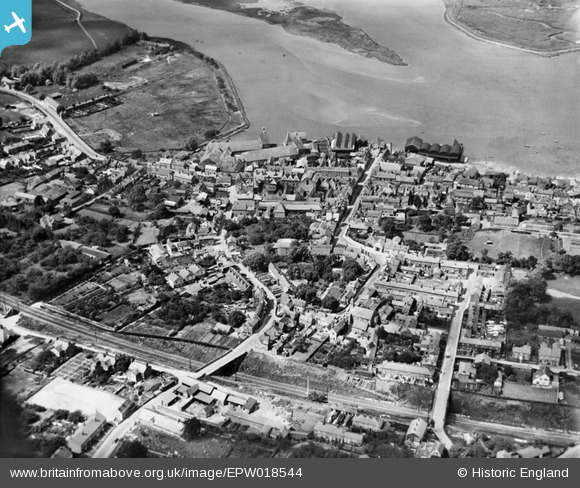
EPW018544 ENGLAND (1927). The town and River Stour, Manningtree, 1927
© Hawlfraint cyfranwyr OpenStreetMap a thrwyddedwyd gan yr OpenStreetMap Foundation. 2026. Trwyddedir y gartograffeg fel CC BY-SA.
Delweddau cyfagos (7)
Manylion
| Pennawd | [EPW018544] The town and River Stour, Manningtree, 1927 |
| Cyfeirnod | EPW018544 |
| Dyddiad | 20-June-1927 |
| Dolen | |
| Enw lle | MANNINGTREE |
| Plwyf | MANNINGTREE |
| Ardal | |
| Gwlad | ENGLAND |
| Dwyreiniad / Gogleddiad | 610629, 231763 |
| Hydred / Lledred | 1.0649549161753, 51.943993932191 |
| Cyfeirnod Grid Cenedlaethol | TM106318 |
Pinnau

BfA events |
Tuesday 1st of October 2013 04:29:24 PM | |

BfA events |
Tuesday 1st of October 2013 04:27:29 PM | |

BfA events |
Tuesday 1st of October 2013 04:26:13 PM | |

Class31 |
Tuesday 30th of October 2012 09:39:38 AM | |

Class31 |
Tuesday 30th of October 2012 09:39:09 AM | |

Class31 |
Tuesday 30th of October 2012 09:38:34 AM | |

Class31 |
Tuesday 30th of October 2012 09:38:18 AM | |

Class31 |
Tuesday 30th of October 2012 09:37:38 AM | |

MB |
Monday 8th of October 2012 12:12:52 PM | |

MB |
Monday 8th of October 2012 12:11:31 PM | |

MB |
Monday 8th of October 2012 12:09:50 PM | |

MB |
Monday 8th of October 2012 12:09:03 PM | |

MB |
Monday 8th of October 2012 12:08:39 PM | |

MB |
Monday 8th of October 2012 12:07:51 PM | |

MB |
Monday 8th of October 2012 12:06:01 PM | |

MB |
Monday 8th of October 2012 12:03:30 PM | |

MB |
Monday 8th of October 2012 12:03:09 PM | |

MB |
Monday 8th of October 2012 12:02:44 PM | |

MB |
Monday 8th of October 2012 12:02:03 PM | |

Anthony Prior |
Thursday 19th of July 2012 05:02:46 PM |


![[EPW018544] The town and River Stour, Manningtree, 1927](http://britainfromabove.org.uk/sites/all/libraries/aerofilms-images/public/100x100/EPW/018/EPW018544.jpg)
![[EAW043685] The town and River Stour, Manningtree, 1952](http://britainfromabove.org.uk/sites/all/libraries/aerofilms-images/public/100x100/EAW/043/EAW043685.jpg)
![[EAW043682] The waterfront and town, Manningtree, 1952](http://britainfromabove.org.uk/sites/all/libraries/aerofilms-images/public/100x100/EAW/043/EAW043682.jpg)
![[EAW043683] The waterfront and town, Manningtree, 1952](http://britainfromabove.org.uk/sites/all/libraries/aerofilms-images/public/100x100/EAW/043/EAW043683.jpg)
![[EPW018542] Brook Street and the town, Manningtree, 1927](http://britainfromabove.org.uk/sites/all/libraries/aerofilms-images/public/100x100/EPW/018/EPW018542.jpg)
![[EAW043684] The town and River Stour, Manningtree, 1952](http://britainfromabove.org.uk/sites/all/libraries/aerofilms-images/public/100x100/EAW/043/EAW043684.jpg)
![[EPW049129] The town and environs, Manningtree, 1935. This image has been produced from a copy-negative.](http://britainfromabove.org.uk/sites/all/libraries/aerofilms-images/public/100x100/EPW/049/EPW049129.jpg)