
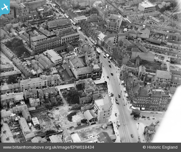
EPW018434 ENGLAND (1927). The YMCA and environs, Leicester, 1927
© Hawlfraint cyfranwyr OpenStreetMap a thrwyddedwyd gan yr OpenStreetMap Foundation. 2026. Trwyddedir y gartograffeg fel CC BY-SA.
Delweddau cyfagos (12)
EPW018434

EPW014913

EAW052685
 Factory on Campbell Street and London Road Railway Station, Leicester, 1953. This image was marked by Aerofilms Ltd for photo editing.")
EAW052684
 Factory on Campbell Street, Leicester, 1953. This image was marked by Aerofilms Ltd for photo editing.")
EAW052686
 Factory on Campbell Street and London Road Railway Station, Leicester, 1953. This image was marked by Aerofilms Ltd for photo editing.")
EAW052689
 Factory on Campbell Street and London Road Railway Station, Leicester, 1953. This image was marked by Aerofilms Ltd for photo editing.")
EAW052688
 Factory on Campbell Street and London Road Railway Station, Leicester, 1953. This image was marked by Aerofilms Ltd for photo editing.")
EAW052682
 Factory on Campbell Street and London Road Railway Station, Leicester, 1953. This image was marked by Aerofilms Ltd for photo editing.")
EAW052687
 Factory on Campbell Street and London Road Railway Station, Leicester, 1953. This image was marked by Aerofilms Ltd for photo editing.")
EAW052683
 Factory on Campbell Street and London Road Railway Station, Leicester, 1953. This image was marked by Aerofilms Ltd for photo editing.")
EAW052678
 Factory on Charles Street, Leicester, 1953. This image was marked by Aerofilms Ltd for photo editing.")
EPW055002

Manylion
| Pennawd | [EPW018434] The YMCA and environs, Leicester, 1927 |
| Cyfeirnod | EPW018434 |
| Dyddiad | 10-June-1927 |
| Dolen | |
| Enw lle | LEICESTER |
| Plwyf | |
| Ardal | |
| Gwlad | ENGLAND |
| Dwyreiniad / Gogleddiad | 459198, 304132 |
| Hydred / Lledred | -1.1252393712733, 52.631358154412 |
| Cyfeirnod Grid Cenedlaethol | SK592041 |
Pinnau

Class31 |
Sunday 10th of February 2013 02:53:46 PM | |

deeb |
Sunday 9th of December 2012 02:23:09 PM | |
|
MB |
Monday 8th of October 2012 10:18:11 AM | |
|
MB |
Monday 8th of October 2012 10:16:29 AM | |
|
MB |
Monday 8th of October 2012 10:14:27 AM | |
|
MB |
Monday 8th of October 2012 10:13:42 AM | |
|
MB |
Monday 8th of October 2012 10:13:15 AM | |
|
MB |
Monday 8th of October 2012 10:11:33 AM | |
|
MB |
Monday 8th of October 2012 10:11:15 AM | |
|
MB |
Monday 8th of October 2012 10:04:07 AM | |
Electric trams served Leicester from circa 1901 until November 1949. |
John W |
Friday 16th of December 2016 09:25:20 PM |
|
MB |
Monday 8th of October 2012 10:02:33 AM |
Cyfraniadau Grŵp
The YMCA is in the centre of the pic and is on East Street and in fact in 2012 is still there in the same building. It is at the start of Grandby Street which runs from the centre of the pic up and bending to the left, At the extreme bottom right corner is just a part of the victorian London Road Railway Station |
Timboishere |
Thursday 28th of June 2012 02:43:49 PM |