
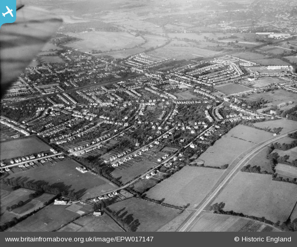
EPW017147 ENGLAND (1926). The town, New Malden, from the south-west, 1926
© Hawlfraint cyfranwyr OpenStreetMap a thrwyddedwyd gan yr OpenStreetMap Foundation. 2026. Trwyddedir y gartograffeg fel CC BY-SA.
Delweddau cyfagos (3)
EPW017147

EPW017336

EPW017146

Manylion
| Pennawd | [EPW017147] The town, New Malden, from the south-west, 1926 |
| Cyfeirnod | EPW017147 |
| Dyddiad | October-1926 |
| Dolen | |
| Enw lle | NEW MALDEN |
| Plwyf | |
| Ardal | |
| Gwlad | ENGLAND |
| Dwyreiniad / Gogleddiad | 520883, 167513 |
| Hydred / Lledred | -0.26231963531697, 51.393265454248 |
| Cyfeirnod Grid Cenedlaethol | TQ209675 |
Pinnau

Johnbg1948 |
Friday 16th of April 2021 08:28:22 PM | |
|
@JohnSouthsea |
Thursday 4th of June 2020 02:02:28 PM | |
|
@JohnSouthsea |
Thursday 4th of June 2020 02:01:35 PM | |
|
@JohnSouthsea |
Thursday 4th of June 2020 02:00:53 PM | |
|
@JohnSouthsea |
Thursday 4th of June 2020 01:59:55 PM | |
|
David |
Monday 6th of April 2015 07:10:43 PM | |
|
mike |
Friday 30th of January 2015 05:53:59 PM | |
|
mike |
Friday 30th of January 2015 05:52:53 PM | |
|
Tom |
Wednesday 19th of November 2014 09:35:35 PM | |
|
Tom |
Wednesday 19th of November 2014 09:35:02 PM | |
|
Tom |
Wednesday 19th of November 2014 09:34:10 PM | |
|
mike |
Friday 21st of February 2014 08:25:22 PM | |
|
mike |
Friday 21st of February 2014 08:22:59 PM | |
|
mike |
Friday 21st of February 2014 08:22:29 PM | |
|
mike |
Friday 21st of February 2014 08:21:52 PM |
Cyfraniadau Grŵp
Does anyone have any information as regards to the houses on Westbury Road, namely 95 and 93 or 97. Much appreciated if any info can be given. Thanks - Tom |
Tom |
Wednesday 19th of November 2014 09:25:04 PM |