
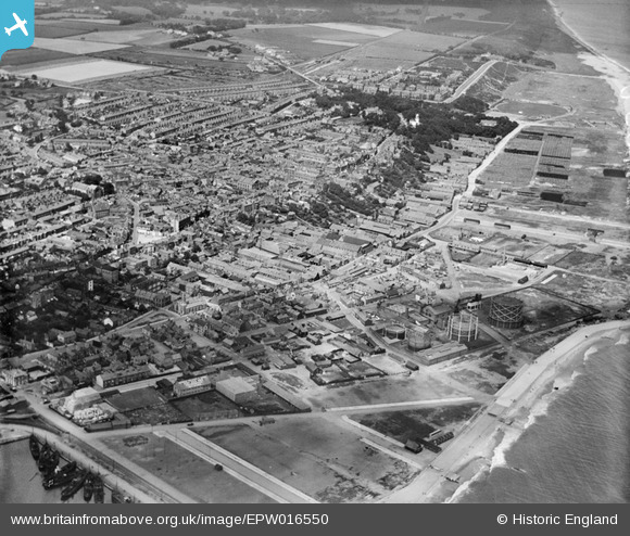
EPW016550 ENGLAND (1926). The Roman Hill area, Lowestoft, from the south-east, 1926
© Hawlfraint cyfranwyr OpenStreetMap a thrwyddedwyd gan yr OpenStreetMap Foundation. 2026. Trwyddedir y gartograffeg fel CC BY-SA.
Delweddau cyfagos (8)
EPW016550

EPW021251

EPW060824

EPW060828

EPW060825

EPW060827

EPW021254

EAW052977

Manylion
| Pennawd | [EPW016550] The Roman Hill area, Lowestoft, from the south-east, 1926 |
| Cyfeirnod | EPW016550 |
| Dyddiad | 26-August-1926 |
| Dolen | |
| Enw lle | LOWESTOFT |
| Plwyf | |
| Ardal | |
| Gwlad | ENGLAND |
| Dwyreiniad / Gogleddiad | 655427, 293327 |
| Hydred / Lledred | 1.761898009869, 52.477608735582 |
| Cyfeirnod Grid Cenedlaethol | TM554933 |
Pinnau

Bart |
Tuesday 13th of June 2023 09:13:04 PM | |
|
Bart |
Thursday 16th of February 2023 12:48:19 AM | |
|
Eddy |
Thursday 20th of August 2020 01:31:05 PM | |
|
Eddy |
Thursday 20th of August 2020 01:29:15 PM | |
|
Eddy |
Thursday 20th of August 2020 01:25:52 PM | |
|
Eddy |
Thursday 20th of August 2020 01:24:34 PM | |
|
Eddy |
Thursday 20th of August 2020 01:23:04 PM | |
|
Eddy |
Thursday 20th of August 2020 01:21:32 PM | |
|
Eddy |
Thursday 20th of August 2020 01:20:05 PM | |
|
Eddy |
Thursday 20th of August 2020 01:19:17 PM | |
|
Eddy |
Wednesday 19th of August 2020 01:54:27 PM | |

Billy Turner |
Friday 11th of September 2015 08:19:16 PM | |
|
c.c |
Tuesday 2nd of September 2014 01:51:37 PM | |
|
c.c |
Tuesday 2nd of September 2014 01:49:38 PM | |
|
Brightonboy |
Saturday 4th of January 2014 09:51:58 PM | |
|
Brightonboy |
Tuesday 16th of April 2013 08:50:51 PM | |
|
Brightonboy |
Tuesday 16th of April 2013 08:49:50 PM | |

Class31 |
Thursday 6th of September 2012 09:13:06 PM | |
|
Class31 |
Thursday 6th of September 2012 09:11:35 PM | |
|
Class31 |
Thursday 6th of September 2012 09:09:13 PM |

Cyfraniadau Grŵp
Not sure I would describe this as The Roman Hill area; Roman Hill is off to the upper left of the picture. The foreground area is (was - much of it has been washed away) The Beach village. The Beach looking towards Gunton would perhaps be a better escription? |
Brightonboy |
Tuesday 16th of April 2013 08:54:32 PM |
This must be the most easterly photo available at present from the Aerofilms library. Ness Point the most easterly point in England is just out of shot to the right of this image. |
Class31 |
Friday 31st of August 2012 07:39:43 PM |