
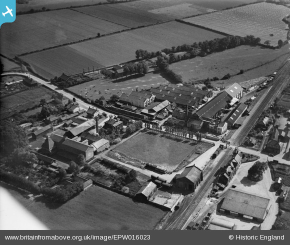
EPW016023 ENGLAND (1926). Gaymers Cider Works, Attleborough, 1926
© Hawlfraint cyfranwyr OpenStreetMap a thrwyddedwyd gan yr OpenStreetMap Foundation. 2025. Trwyddedir y gartograffeg fel CC BY-SA.
Delweddau cyfagos (14)
EPW016023

EPW039230

EPW016028

EPW039231

EPW016020

EPW016024

EPW016025

EPW016026

EPW016027

EPW039235

EPW016021

EPW039229

EPW016019

EPW016022

Manylion
| Pennawd | [EPW016023] Gaymers Cider Works, Attleborough, 1926 |
| Cyfeirnod | EPW016023 |
| Dyddiad | 1-July-1926 |
| Dolen | |
| Enw lle | ATTLEBOROUGH |
| Plwyf | ATTLEBOROUGH |
| Ardal | |
| Gwlad | ENGLAND |
| Dwyreiniad / Gogleddiad | 605185, 294930 |
| Hydred / Lledred | 1.0241843450929, 52.513205755404 |
| Cyfeirnod Grid Cenedlaethol | TM052949 |
Pinnau

Class31 |
Wednesday 30th of January 2013 10:06:29 AM | |

MB |
Sunday 30th of September 2012 11:07:11 PM | |
|
MB |
Sunday 30th of September 2012 11:06:30 PM | |
|
MB |
Sunday 30th of September 2012 11:03:15 PM | |
|
MB |
Sunday 30th of September 2012 11:02:11 PM | |
|
MB |
Sunday 30th of September 2012 11:01:33 PM | |
|
MB |
Sunday 30th of September 2012 11:01:04 PM | |
|
MB |
Sunday 30th of September 2012 11:00:39 PM | |
|
MB |
Sunday 30th of September 2012 11:00:14 PM | |
|
MB |
Sunday 30th of September 2012 10:59:39 PM | |
|
MB |
Sunday 30th of September 2012 10:59:03 PM | |
|
MB |
Sunday 30th of September 2012 10:58:39 PM | |
|
MB |
Sunday 30th of September 2012 10:58:16 PM |
Cyfraniadau Grŵp
Looking south west. Somewhat unusually the station platforms are staggered - located either side of the level crossing. The crossing has been equipped with side gates for pedestrians |
MB |
Sunday 30th of September 2012 11:06:03 PM |