
EPW013694 ENGLAND (1925). Hoylake Road and environs, Bidston, 1925
© Hawlfraint cyfranwyr OpenStreetMap a thrwyddedwyd gan yr OpenStreetMap Foundation. 2026. Trwyddedir y gartograffeg fel CC BY-SA.
Delweddau cyfagos (4)
EPW013694

EPW013696

EPW013698

EPW013695

Manylion
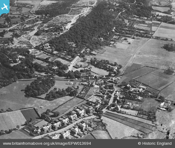
| Pennawd | [EPW013694] Hoylake Road and environs, Bidston, 1925 |
| Cyfeirnod | EPW013694 |
| Dyddiad | 12-July-1925 |
| Dolen | |
| Enw lle | BIDSTON |
| Plwyf | |
| Ardal | |
| Gwlad | ENGLAND |
| Dwyreiniad / Gogleddiad | 328458, 390158 |
| Hydred / Lledred | -3.0762066115923, 53.403127437719 |
| Cyfeirnod Grid Cenedlaethol | SJ285902 |
Pinnau

Victoria |
Saturday 15th of October 2022 05:53:02 AM | |
|
Victoria |
Saturday 15th of October 2022 05:52:07 AM | |
|
Victoria |
Saturday 15th of October 2022 05:48:46 AM | |
|
BobH |
Monday 30th of November 2020 07:00:59 AM | |
|
Colin |
Saturday 21st of December 2019 03:57:39 PM | |
|
Graham |
Tuesday 16th of July 2019 09:36:13 AM | |
|
Graham |
Tuesday 16th of July 2019 09:35:44 AM | |
|
Graham |
Tuesday 16th of July 2019 09:34:36 AM | |
|
Graham |
Tuesday 16th of July 2019 09:32:29 AM | |
|
Graham |
Tuesday 16th of July 2019 09:32:00 AM | |
|
BobH |
Thursday 7th of July 2016 03:30:55 PM | |
|
BobH |
Thursday 7th of July 2016 03:25:08 PM | |
|
BobH |
Thursday 7th of July 2016 03:24:15 PM | |
|
BobH |
Thursday 7th of July 2016 03:10:49 PM | |
|
Kenfarrell@gmail.com |
Saturday 25th of August 2012 01:59:28 PM | |
|
Bob Fraser |
Tuesday 3rd of July 2012 04:00:41 PM | |
|
Bob Fraser |
Tuesday 26th of June 2012 03:55:10 PM | |
|
Bob Fraser |
Tuesday 26th of June 2012 03:53:30 PM | |
|
Bob Fraser |
Tuesday 26th of June 2012 03:53:15 PM | |
|
Bob Fraser |
Tuesday 26th of June 2012 03:52:45 PM |
Cyfraniadau Grŵp
This photo does not contain hoylake road in it The road on the top left by the church is boundary road |
BobH |
Thursday 7th of July 2016 03:31:57 PM |