
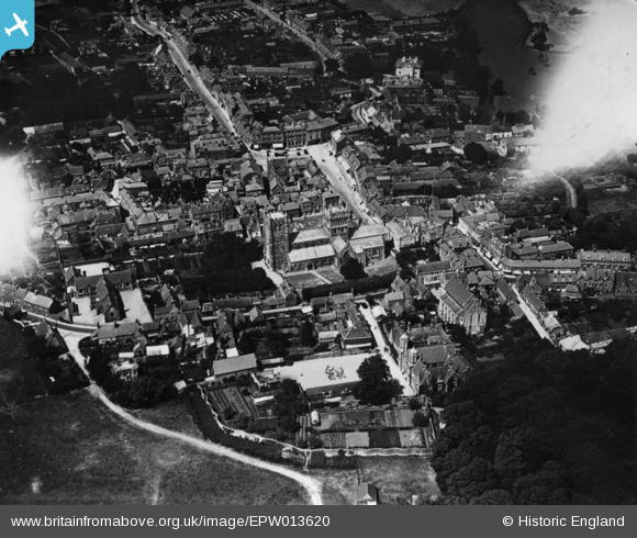
EPW013620 ENGLAND (1925). The Minster Church of St Cuthberga and the town, Wimborne, 1925. This image has been produced from a print.
© Hawlfraint cyfranwyr OpenStreetMap a thrwyddedwyd gan yr OpenStreetMap Foundation. 2026. Trwyddedir y gartograffeg fel CC BY-SA.
Delweddau cyfagos (7)
EPW013620

EPW013621

EAW024381

EAW024382

EAW024380

EPW013623

EAW024379

Manylion
| Pennawd | [EPW013620] The Minster Church of St Cuthberga and the town, Wimborne, 1925. This image has been produced from a print. |
| Cyfeirnod | EPW013620 |
| Dyddiad | June-1925 |
| Dolen | |
| Enw lle | WIMBORNE |
| Plwyf | WIMBORNE MINSTER |
| Ardal | |
| Gwlad | ENGLAND |
| Dwyreiniad / Gogleddiad | 400929, 99925 |
| Hydred / Lledred | -1.9868164501169, 50.798321138423 |
| Cyfeirnod Grid Cenedlaethol | SZ009999 |
Pinnau

Class31 |
Sunday 6th of September 2015 05:39:06 PM |

Cyfraniadau Grŵp

The Minster Church of St Cuthberga, Wimborne Minster, 05/09/2015 |
Class31 |
Sunday 6th of September 2015 05:46:09 PM |