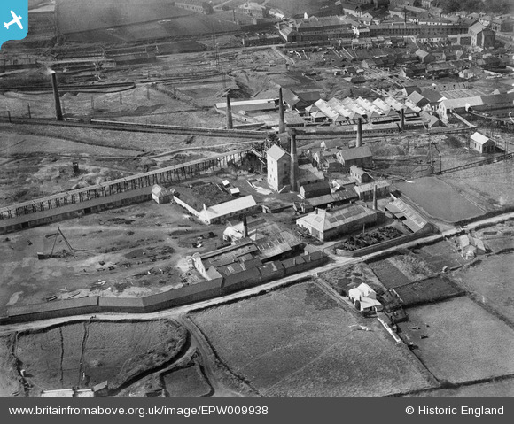
EPW009938 ENGLAND (1924). New Cook's Kitchen Mine and Iron Foundry, Redruth, 1924
    © Hawlfraint cyfranwyr OpenStreetMap a thrwyddedwyd gan yr OpenStreetMap Foundation. 2025. Trwyddedir y gartograffeg fel CC BY-SA.
  
Delweddau cyfagos (7)
Manylion
| Pennawd | [EPW009938] New Cook's Kitchen Mine and Iron Foundry, Redruth, 1924 | 
| Cyfeirnod | EPW009938 | 
| Dyddiad | March-1924 | 
| Dolen | |
| Enw lle | REDRUTH | 
| Plwyf | CARN BREA | 
| Ardal | |
| Gwlad | ENGLAND | 
| Dwyreiniad / Gogleddiad | 166462, 40940 | 
| Hydred / Lledred | -5.2743629926633, 50.221659974355 | 
| Cyfeirnod Grid Cenedlaethol | SW665409 | 
Pinnau
Byddwch y cyntaf i ychwanegu sylw at y ddelwedd hon!
 
             
  ![[EPW009938] New Cook's Kitchen Mine and Iron Foundry, Redruth, 1924](http://britainfromabove.org.uk/sites/all/libraries/aerofilms-images/public/100x100/EPW/009/EPW009938.jpg) 
  
                                          ![[EAW033642] South Crofty Tin Mine and environs, Brae, from the south-west, 1950](http://britainfromabove.org.uk/sites/all/libraries/aerofilms-images/public/100x100/EAW/033/EAW033642.jpg) 
 ![[EAW033644] South Crofty Tin Mine and environs, Brae, 1950](http://britainfromabove.org.uk/sites/all/libraries/aerofilms-images/public/100x100/EAW/033/EAW033644.jpg) 
 ![[EPW059588] South Crofty Tin Mine, Brea, from the south, 1938](http://britainfromabove.org.uk/sites/all/libraries/aerofilms-images/public/100x100/EPW/059/EPW059588.jpg) 
 ![[EAW033643] South Crofty Tin Mine and environs, Brae, from the south, 1950](http://britainfromabove.org.uk/sites/all/libraries/aerofilms-images/public/100x100/EAW/033/EAW033643.jpg) 
 ![[EPW009935] New Cook's Kitchen Mine and the Rock Drill Works, Redruth, from the south-east, 1924](http://britainfromabove.org.uk/sites/all/libraries/aerofilms-images/public/100x100/EPW/009/EPW009935.jpg) 
 ![[EPW059668] The remains of tin mining around Tuckingmill, Carn Brea, 1938](http://britainfromabove.org.uk/sites/all/libraries/aerofilms-images/public/100x100/EPW/059/EPW059668.jpg)