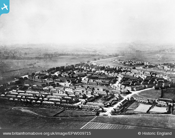
EPW009715 ENGLAND (1923). The Becontree Estate around Bennett's Castle Lane and Lindisfarne Road, Becontree, from the north-east, 1923. This image has been produced from a copy-negative.
    © Hawlfraint cyfranwyr OpenStreetMap a thrwyddedwyd gan yr OpenStreetMap Foundation. 2025. Trwyddedir y gartograffeg fel CC BY-SA.
  
Manylion
| Pennawd | [EPW009715] The Becontree Estate around Bennett's Castle Lane and Lindisfarne Road, Becontree, from the north-east, 1923. This image has been produced from a copy-negative. | 
| Cyfeirnod | EPW009715 | 
| Dyddiad | 1923 | 
| Dolen | |
| Enw lle | BECONTREE | 
| Plwyf | |
| Ardal | |
| Gwlad | ENGLAND | 
| Dwyreiniad / Gogleddiad | 547638, 186156 | 
| Hydred / Lledred | 0.12981285239506, 51.554466758175 | 
| Cyfeirnod Grid Cenedlaethol | TQ476862 | 
Pinnau
Byddwch y cyntaf i ychwanegu sylw at y ddelwedd hon!
 
             
  ![[EPW009715] The Becontree Estate around Bennett's Castle Lane and Lindisfarne Road, Becontree, from the north-east, 1923. This image has been produced from a copy-negative.](http://britainfromabove.org.uk/sites/all/libraries/aerofilms-images/public/100x100/EPW/009/EPW009715.jpg) 
  
                                          ![[EPW024283] Housing surrounding Lindisfarne Road, Becontree, from the north-west, 1928](http://britainfromabove.org.uk/sites/all/libraries/aerofilms-images/public/100x100/EPW/024/EPW024283.jpg) 
 ![[EPW009713] The Becontree Estate around Linkway and Campden Crescent, Becontree, from the east, 1923. This image has been produced from a copy-negative.](http://britainfromabove.org.uk/sites/all/libraries/aerofilms-images/public/100x100/EPW/009/EPW009713.jpg) 
 ![[EPW009714] The Becontree Estate around Farmway, Becontree, from the south-east, 1923. This image has been produced from a copy-negative.](http://britainfromabove.org.uk/sites/all/libraries/aerofilms-images/public/100x100/EPW/009/EPW009714.jpg)