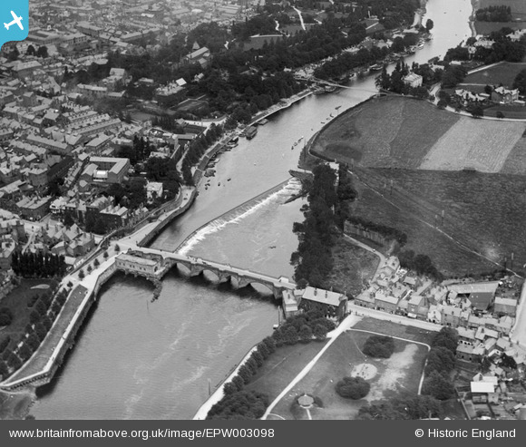
EPW003098 ENGLAND (1920). The Dee Bridge, Chester, 1920
    © Hawlfraint cyfranwyr OpenStreetMap a thrwyddedwyd gan yr OpenStreetMap Foundation. 2025. Trwyddedir y gartograffeg fel CC BY-SA.
  
Delweddau cyfagos (11)
Manylion
| Pennawd | [EPW003098] The Dee Bridge, Chester, 1920 | 
| Cyfeirnod | EPW003098 | 
| Dyddiad | July-1920 | 
| Dolen | |
| Enw lle | CHESTER | 
| Plwyf | |
| Ardal | |
| Gwlad | ENGLAND | 
| Dwyreiniad / Gogleddiad | 340785, 365830 | 
| Hydred / Lledred | -2.8862603039469, 53.185977722953 | 
| Cyfeirnod Grid Cenedlaethol | SJ408658 | 
Pinnau
|   RachelMC | Friday 15th of May 2015 08:40:27 PM | |
|  Old Queen's Park suspension bridge built in 1852. Replaced in 1923. |   London1955 | Saturday 13th of July 2013 06:59:32 AM | 
|  School |   MB | Tuesday 27th of November 2012 11:15:13 AM | 
|  Public house |   MB | Tuesday 27th of November 2012 11:14:06 AM | 
|  Duke Street |   MB | Tuesday 27th of November 2012 11:13:42 AM | 
|  Mill Street |   MB | Tuesday 27th of November 2012 11:12:36 AM | 
|  Edgar's Field |   MB | Tuesday 27th of November 2012 11:11:53 AM | 
|  City wall and walkway |   MB | Tuesday 27th of November 2012 10:59:06 AM | 
|  Edgar House - in 1900 |   MB | Tuesday 27th of November 2012 10:58:21 AM | 
|  The weir is the highest point on the river to which ordinary tides flow |   MB | Tuesday 27th of November 2012 10:54:29 AM | 
|  City wall with walkway |   MB | Tuesday 27th of November 2012 10:52:58 AM | 
|  Old quarry |   MB | Tuesday 27th of November 2012 10:52:15 AM | 
|  Bandstand in a park |   MB | Tuesday 27th of November 2012 10:51:34 AM | 
| Actually just a shelter placed on top of a sandstone outcrop of the old Roman Quarry. This was never used as a bandstand. |   RachelMC | Friday 15th of May 2015 08:38:36 PM | 
|  The Dee was navigable up to Dee Mills. Until the fire in 1895, grain could be shipped in by water and flour exported |   MB | Tuesday 27th of November 2012 10:51:02 AM | 
|  Site of Water Engine, extant in 1791 - used to pump water to the city |   MB | Tuesday 27th of November 2012 10:49:25 AM | 
|  Skinner's Lane in 1900 |   MB | Tuesday 27th of November 2012 10:47:28 AM | 
|  Site of tannery, extant in 1833 [Map by Wood] |   MB | Tuesday 27th of November 2012 10:46:56 AM | 
|  Bridge Gate |   MB | Tuesday 27th of November 2012 10:42:41 AM | 
|  Millrace |   MB | Tuesday 27th of November 2012 10:42:04 AM | 
|  Snuff mill here in 1791 [Map by Poole]; Tobacco and Snuff Manufactory in 1900 [Ordnance Survey] |   MB | Tuesday 27th of November 2012 10:41:47 AM | 
|  The site of the five storey (plus attics) Dee Mills, largelt destroyed by fire in 1895. A hydro-electric power station was established here in 1913. It remained largely unaltered externally in 1996. [Source: Roy Wilding, Miller of Dee, pub Gordon Emery 1997] |   MB | Tuesday 27th of November 2012 10:31:52 AM | 
 
             
  ![[EPW003098] The Dee Bridge, Chester, 1920](http://britainfromabove.org.uk/sites/all/libraries/aerofilms-images/public/100x100/EPW/003/EPW003098.jpg) 
  
                                          ![[EPW004004] The Dee Bridge, Chester, 1920](http://britainfromabove.org.uk/sites/all/libraries/aerofilms-images/public/100x100/EPW/004/EPW004004.jpg) 
 ![[EPW058012] St Mary's Church, Dee Bridge and the town, Chester, 1938](http://britainfromabove.org.uk/sites/all/libraries/aerofilms-images/public/100x100/EPW/058/EPW058012.jpg) 
 ![[EPW004002] Dee Bridge and Lower Bridge Street, Chester, 1920. This image has been produced from a print.](http://britainfromabove.org.uk/sites/all/libraries/aerofilms-images/public/100x100/EPW/004/EPW004002.jpg) 
 ![[EPW040163] The Suspension Bridge, Dee Bridge and Grosvenor Bridge on the River Dee and environs, Chester, 1932](http://britainfromabove.org.uk/sites/all/libraries/aerofilms-images/public/100x100/EPW/040/EPW040163.jpg) 
 ![[EPW058003] The River Dee and the city, Chester, 1938. This image has been produced from a print.](http://britainfromabove.org.uk/sites/all/libraries/aerofilms-images/public/100x100/EPW/058/EPW058003.jpg) 
 ![[EPW003088] Lower Bridge Street and environs, Chester, 1920. This image has been produced from a copy-negative.](http://britainfromabove.org.uk/sites/all/libraries/aerofilms-images/public/100x100/EPW/003/EPW003088.jpg) 
 ![[EPW003095] Queen's Park Bridge, Chester, 1920](http://britainfromabove.org.uk/sites/all/libraries/aerofilms-images/public/100x100/EPW/003/EPW003095.jpg) 
 ![[EPW029590] City High School, Chester, 1929. This image has been produced from a print.](http://britainfromabove.org.uk/sites/all/libraries/aerofilms-images/public/100x100/EPW/029/EPW029590.jpg) 
 ![[EPW058005] The Castle, Dee Bridge and the town, Chester, 1938. This image has been produced from a damaged negative.](http://britainfromabove.org.uk/sites/all/libraries/aerofilms-images/public/100x100/EPW/058/EPW058005.jpg) 
 ![[EPW005886] Queen's Park Suspension Bridge and the River Dee, Chester, 1921. This image has been produced from a copy-negative.](http://britainfromabove.org.uk/sites/all/libraries/aerofilms-images/public/100x100/EPW/005/EPW005886.jpg) 
 