
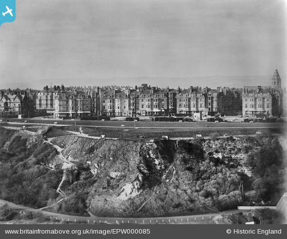
EPW000085 ENGLAND (1920). The Leas, Folkestone, 1920
© Hawlfraint cyfranwyr OpenStreetMap a thrwyddedwyd gan yr OpenStreetMap Foundation. 2026. Trwyddedir y gartograffeg fel CC BY-SA.
Delweddau cyfagos (13)
EPW000085

EPW000583

EPW000082

EAW024829

EPW000592

EAW024833

EPW000077

EAW002374

EAW002375

EPW000366

EPW009201

EAW002854

EPW000364

Manylion
| Pennawd | [EPW000085] The Leas, Folkestone, 1920 |
| Cyfeirnod | EPW000085 |
| Dyddiad | February-1920 |
| Dolen | |
| Enw lle | FOLKESTONE |
| Plwyf | FOLKESTONE |
| Ardal | |
| Gwlad | ENGLAND |
| Dwyreiniad / Gogleddiad | 621931, 135415 |
| Hydred / Lledred | 1.1685014994328, 51.074543075407 |
| Cyfeirnod Grid Cenedlaethol | TR219354 |
Pinnau

Paolo |
Monday 14th of September 2015 09:39:04 PM | |
|
Paolo |
Monday 14th of September 2015 09:29:59 PM | |
|
Paolo |
Monday 3rd of December 2012 03:30:31 PM |
Cyfraniadau Grŵp
Shows the western half of Clifton Crescent, withthe Manor House at far left and Holy Trinity Church at far right. But what is the cuboid structure opposite the gap in the buildings leading to the church? Is it left over from Rest Camp 3 in WW1? |
Paolo |
Wednesday 27th of June 2012 04:22:27 PM |