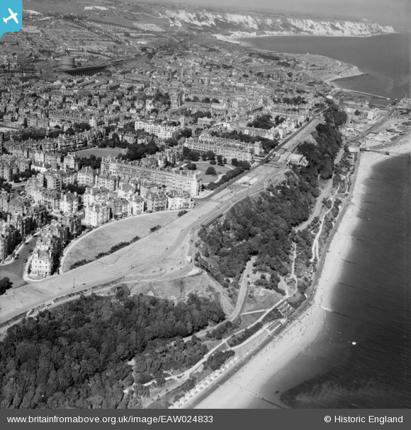
EAW024833 ENGLAND (1949). West Cliff, Folkestone, from the south-west, 1949
© Hawlfraint cyfranwyr OpenStreetMap a thrwyddedwyd gan yr OpenStreetMap Foundation. 2026. Trwyddedir y gartograffeg fel CC BY-SA.
Delweddau cyfagos (13)
Manylion
| Pennawd | [EAW024833] West Cliff, Folkestone, from the south-west, 1949 |
| Cyfeirnod | EAW024833 |
| Dyddiad | 12-July-1949 |
| Dolen | |
| Enw lle | FOLKESTONE |
| Plwyf | FOLKESTONE |
| Ardal | |
| Gwlad | ENGLAND |
| Dwyreiniad / Gogleddiad | 622004, 135315 |
| Hydred / Lledred | 1.1694806078009, 51.073616901976 |
| Cyfeirnod Grid Cenedlaethol | TR220353 |


![[EAW024833] West Cliff, Folkestone, from the south-west, 1949](http://britainfromabove.org.uk/sites/all/libraries/aerofilms-images/public/100x100/EAW/024/EAW024833.jpg)
![[EPW000583] Clifton Crescent, Folkestone, 1920](http://britainfromabove.org.uk/sites/all/libraries/aerofilms-images/public/100x100/EPW/000/EPW000583.jpg)
![[EAW002374] Clifton Crescent and The Leas, Folkestone, 1946](http://britainfromabove.org.uk/sites/all/libraries/aerofilms-images/public/100x100/EAW/002/EAW002374.jpg)
![[EPW000082] Clifton Crescent and Holy Trinity Church, Folkestone, 1920](http://britainfromabove.org.uk/sites/all/libraries/aerofilms-images/public/100x100/EPW/000/EPW000082.jpg)
![[EPW000085] The Leas, Folkestone, 1920](http://britainfromabove.org.uk/sites/all/libraries/aerofilms-images/public/100x100/EPW/000/EPW000085.jpg)
![[EAW002375] The Leas, Folkestone, 1946](http://britainfromabove.org.uk/sites/all/libraries/aerofilms-images/public/100x100/EAW/002/EAW002375.jpg)
![[EPW000592] Clifton Crescent and Westcliff, Folkestone, from the west, 1920](http://britainfromabove.org.uk/sites/all/libraries/aerofilms-images/public/100x100/EPW/000/EPW000592.jpg)
![[EAW024829] Clifton Crescent and environs, Folkestone, 1949](http://britainfromabove.org.uk/sites/all/libraries/aerofilms-images/public/100x100/EAW/024/EAW024829.jpg)
![[EPW009201] Clifton Gardens and The Leas, Folkestone, 1923](http://britainfromabove.org.uk/sites/all/libraries/aerofilms-images/public/100x100/EPW/009/EPW009201.jpg)
![[EAW024828] The bandstand and the Pulhamite Rock Garden on the Leas, Folkestone, 1949](http://britainfromabove.org.uk/sites/all/libraries/aerofilms-images/public/100x100/EAW/024/EAW024828.jpg)
![[EPW000077] Cliff Railway, Folkestone, 1920](http://britainfromabove.org.uk/sites/all/libraries/aerofilms-images/public/100x100/EPW/000/EPW000077.jpg)
![[EAW002854] West Cliff, Clifton Gardens and the surrounding residential area, Folkestone, 1946](http://britainfromabove.org.uk/sites/all/libraries/aerofilms-images/public/100x100/EAW/002/EAW002854.jpg)
![[EPW000364] Clifton Gardens, Folkestone, 1920](http://britainfromabove.org.uk/sites/all/libraries/aerofilms-images/public/100x100/EPW/000/EPW000364.jpg)
