
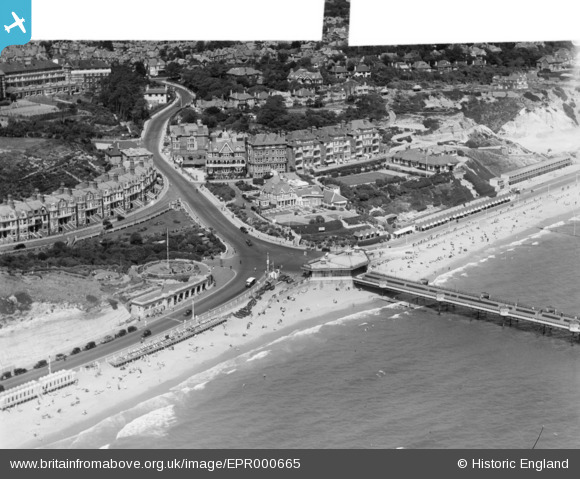
EPR000665 ENGLAND (1935). The pier and Sea Road, Boscombe, 1935. This image was marked by Aero Pictorial Ltd for photo editing.
© Hawlfraint cyfranwyr OpenStreetMap a thrwyddedwyd gan yr OpenStreetMap Foundation. 2026. Trwyddedir y gartograffeg fel CC BY-SA.
Delweddau cyfagos (15)
EPR000665

EPR000287

EPW013565

EPW018169

EAW035604

EPR000668

EPR000669

EAW049058

EAW035606

EPW037435

EPW000257

EPW037436

EPW013559

EPW041051

EPR000288

Manylion
| Pennawd | [EPR000665] The pier and Sea Road, Boscombe, 1935. This image was marked by Aero Pictorial Ltd for photo editing. |
| Cyfeirnod | EPR000665 |
| Dyddiad | 26-June-1935 |
| Dolen | |
| Enw lle | BOSCOMBE |
| Plwyf | |
| Ardal | |
| Gwlad | ENGLAND |
| Dwyreiniad / Gogleddiad | 411181, 91201 |
| Hydred / Lledred | -1.8415945081613, 50.719753692135 |
| Cyfeirnod Grid Cenedlaethol | SZ112912 |
Pinnau
Byddwch y cyntaf i ychwanegu sylw at y ddelwedd hon!