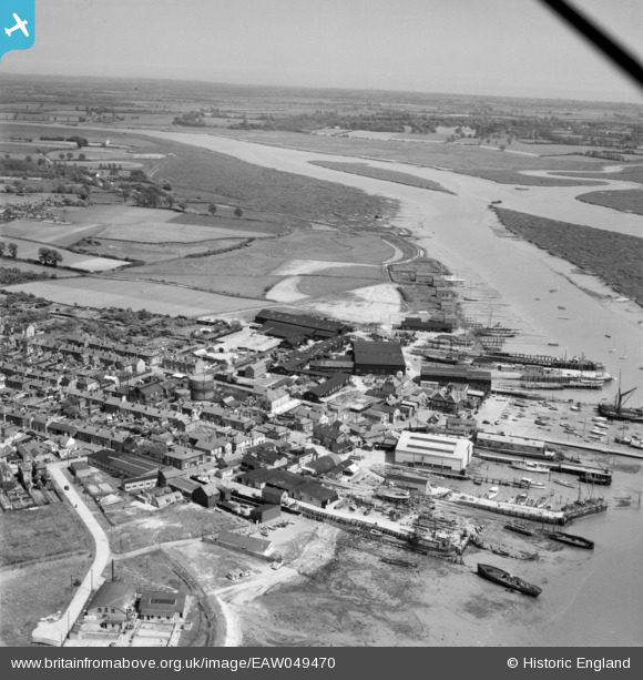
EAW049470 ENGLAND (1953). The waterfront and Brightlingsea Creek, Brightlingsea, from the west, 1953
© Hawlfraint cyfranwyr OpenStreetMap a thrwyddedwyd gan yr OpenStreetMap Foundation. 2026. Trwyddedir y gartograffeg fel CC BY-SA.
Delweddau cyfagos (12)
Manylion
| Pennawd | [EAW049470] The waterfront and Brightlingsea Creek, Brightlingsea, from the west, 1953 |
| Cyfeirnod | EAW049470 |
| Dyddiad | 19-May-1953 |
| Dolen | |
| Enw lle | BRIGHTLINGSEA |
| Plwyf | BRIGHTLINGSEA |
| Ardal | |
| Gwlad | ENGLAND |
| Dwyreiniad / Gogleddiad | 608477, 216250 |
| Hydred / Lledred | 1.0243197177171, 51.805507698702 |
| Cyfeirnod Grid Cenedlaethol | TM085163 |
Pinnau

Deather |
Wednesday 2nd of December 2015 02:23:35 PM | |

ken |
Monday 10th of August 2015 08:56:56 PM | |

MB |
Monday 9th of June 2014 10:32:33 AM | |

MB |
Monday 9th of June 2014 10:32:02 AM | |

MB |
Monday 9th of June 2014 10:31:10 AM | |

MB |
Monday 9th of June 2014 10:30:04 AM | |

MB |
Monday 9th of June 2014 10:29:35 AM | |

MB |
Monday 9th of June 2014 10:29:12 AM | |

MB |
Monday 9th of June 2014 10:28:41 AM | |

MB |
Monday 9th of June 2014 10:24:44 AM | |

MB |
Monday 9th of June 2014 10:24:17 AM |


![[EAW049470] The waterfront and Brightlingsea Creek, Brightlingsea, from the west, 1953](http://britainfromabove.org.uk/sites/all/libraries/aerofilms-images/public/100x100/EAW/049/EAW049470.jpg)
![[EAW049471] The waterfront and town, Brightlingsea, from the west, 1953](http://britainfromabove.org.uk/sites/all/libraries/aerofilms-images/public/100x100/EAW/049/EAW049471.jpg)
![[EPW041412] The Shipbuilding Yard, Brightlingsea, 1933](http://britainfromabove.org.uk/sites/all/libraries/aerofilms-images/public/100x100/EPW/041/EPW041412.jpg)
![[EPW014283] The wharf and the town, Brightlingsea, 1925. This image has been produced from a print.](http://britainfromabove.org.uk/sites/all/libraries/aerofilms-images/public/100x100/EPW/014/EPW014283.jpg)
![[EPW041414] The Shipbuilding Yard, Brightlingsea, 1933](http://britainfromabove.org.uk/sites/all/libraries/aerofilms-images/public/100x100/EPW/041/EPW041414.jpg)
![[EPW041410] The town, Brightlingsea, 1933](http://britainfromabove.org.uk/sites/all/libraries/aerofilms-images/public/100x100/EPW/041/EPW041410.jpg)
![[EPW014285] Waterside and environs, Brightlingsea, 1925. This image has been produced from a copy-negative.](http://britainfromabove.org.uk/sites/all/libraries/aerofilms-images/public/100x100/EPW/014/EPW014285.jpg)
![[EPW014282] The wharf and the town, Brightlingsea, 1925. This image has been produced from a print.](http://britainfromabove.org.uk/sites/all/libraries/aerofilms-images/public/100x100/EPW/014/EPW014282.jpg)
![[EAW024664] Brightlingsea Creek, the waterfront and town, Brightlingsea, from the south-east, 1949](http://britainfromabove.org.uk/sites/all/libraries/aerofilms-images/public/100x100/EAW/024/EAW024664.jpg)
![[EAW024663] Brightlingsea Creek, the waterfront and town, Brightlingsea, from the south-east, 1949](http://britainfromabove.org.uk/sites/all/libraries/aerofilms-images/public/100x100/EAW/024/EAW024663.jpg)
![[EAW049472] The waterfront and town, Brightlingsea, from the south, 1953](http://britainfromabove.org.uk/sites/all/libraries/aerofilms-images/public/100x100/EAW/049/EAW049472.jpg)
![[EPW041411] The town, Brightlingsea, from the south-east, 1933](http://britainfromabove.org.uk/sites/all/libraries/aerofilms-images/public/100x100/EPW/041/EPW041411.jpg)