
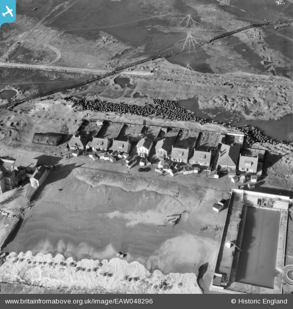
EAW048296 ENGLAND (1953). Storm damaged beach huts blown up against houses along Manor Terrace, Felixstowe, 1953
© Hawlfraint cyfranwyr OpenStreetMap a thrwyddedwyd gan yr OpenStreetMap Foundation. 2026. Trwyddedir y gartograffeg fel CC BY-SA.
Delweddau cyfagos (4)
EAW048296

EAW048293

EAW048292

EAW048295

Manylion
| Pennawd | [EAW048296] Storm damaged beach huts blown up against houses along Manor Terrace, Felixstowe, 1953 |
| Cyfeirnod | EAW048296 |
| Dyddiad | 2-February-1953 |
| Dolen | |
| Enw lle | FELIXSTOWE |
| Plwyf | FELIXSTOWE |
| Ardal | |
| Gwlad | ENGLAND |
| Dwyreiniad / Gogleddiad | 629045, 232691 |
| Hydred / Lledred | 1.333082158604, 51.945048937884 |
| Cyfeirnod Grid Cenedlaethol | TM290327 |
Pinnau

Sparky |
Wednesday 25th of October 2017 11:58:48 PM | |

cptpies |
Tuesday 10th of March 2015 12:39:21 PM | |
|
cptpies |
Tuesday 10th of March 2015 12:37:01 PM | |
|
cptpies |
Tuesday 10th of March 2015 12:27:57 PM |
Cyfraniadau Grŵp

ATB's, SME and practice trenches, Felixtowe |
cptpies |
Tuesday 10th of March 2015 12:38:22 PM |