
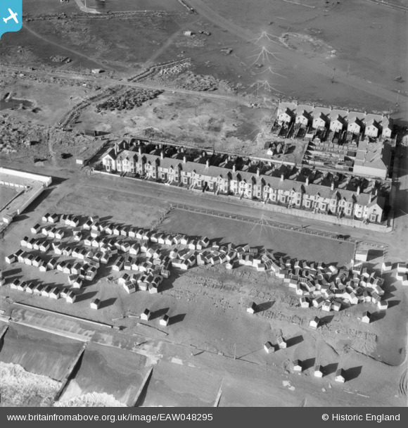
EAW048295 ENGLAND (1953). Storm damaged beach huts next to the putting green on the beach near Manor Road, Felixstowe, 1953
© Hawlfraint cyfranwyr OpenStreetMap a thrwyddedwyd gan yr OpenStreetMap Foundation. 2026. Trwyddedir y gartograffeg fel CC BY-SA.
Delweddau cyfagos (3)
EAW048295

EAW048289

EAW048296

Manylion
| Pennawd | [EAW048295] Storm damaged beach huts next to the putting green on the beach near Manor Road, Felixstowe, 1953 |
| Cyfeirnod | EAW048295 |
| Dyddiad | 2-February-1953 |
| Dolen | |
| Enw lle | FELIXSTOWE |
| Plwyf | FELIXSTOWE |
| Ardal | |
| Gwlad | ENGLAND |
| Dwyreiniad / Gogleddiad | 629177, 232908 |
| Hydred / Lledred | 1.3351441579109, 51.946942501649 |
| Cyfeirnod Grid Cenedlaethol | TM292329 |
Pinnau

Matt Aldred edob.mattaldred.com |
Monday 8th of March 2021 12:03:14 PM | |
|
Matt Aldred edob.mattaldred.com |
Monday 8th of March 2021 12:03:02 PM | |
|
Matt Aldred edob.mattaldred.com |
Monday 8th of March 2021 12:02:41 PM | |

Sparky |
Wednesday 25th of October 2017 11:57:47 PM | |
|
Sparky |
Wednesday 25th of October 2017 11:57:30 PM |