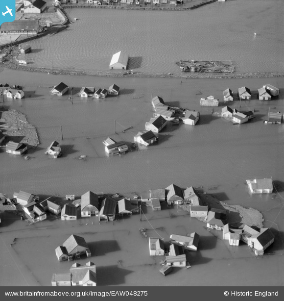
EAW048275 ENGLAND (1953). Flooding at Sea Way, Sea Crescent and Lake Way, Jaywick, 1953
    © Hawlfraint cyfranwyr OpenStreetMap a thrwyddedwyd gan yr OpenStreetMap Foundation. 2025. Trwyddedir y gartograffeg fel CC BY-SA.
  
Manylion
| Pennawd | [EAW048275] Flooding at Sea Way, Sea Crescent and Lake Way, Jaywick, 1953 | 
| Cyfeirnod | EAW048275 | 
| Dyddiad | 2-March-1953 | 
| Dolen | |
| Enw lle | JAYWICK | 
| Plwyf | |
| Ardal | |
| Gwlad | ENGLAND | 
| Dwyreiniad / Gogleddiad | 614784, 212977 | 
| Hydred / Lledred | 1.1136437990568, 51.773733158284 | 
| Cyfeirnod Grid Cenedlaethol | TM148130 | 
Pinnau
Byddwch y cyntaf i ychwanegu sylw at y ddelwedd hon!
 
             
  ![[EAW048275] Flooding at Sea Way, Sea Crescent and Lake Way, Jaywick, 1953](http://britainfromabove.org.uk/sites/all/libraries/aerofilms-images/public/100x100/EAW/048/EAW048275.jpg) 
  
                                          ![[EAW048274] Flooding at Sea Way, Jaywick, 1953](http://britainfromabove.org.uk/sites/all/libraries/aerofilms-images/public/100x100/EAW/048/EAW048274.jpg) 
 ![[EAW048265] Damaged sea defences and flooding around Swift Avenue and Talbot Avenue, Jaywick, 1953](http://britainfromabove.org.uk/sites/all/libraries/aerofilms-images/public/100x100/EAW/048/EAW048265.jpg) 
 ![[EAW048263] Damaged sea defences and flooding along the Essex coast, Jaywick, from the east, 1953. This image has been produced from a print.](http://britainfromabove.org.uk/sites/all/libraries/aerofilms-images/public/100x100/EAW/048/EAW048263.jpg)