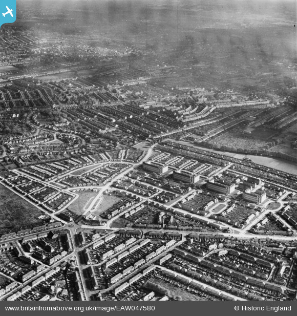
EAW047580 ENGLAND (1952). Pollards Hill, Mitcham, from the west, 1952
© Hawlfraint cyfranwyr OpenStreetMap a thrwyddedwyd gan yr OpenStreetMap Foundation. 2026. Trwyddedir y gartograffeg fel CC BY-SA.
Manylion
| Pennawd | [EAW047580] Pollards Hill, Mitcham, from the west, 1952 |
| Cyfeirnod | EAW047580 |
| Dyddiad | 23-October-1952 |
| Dolen | |
| Enw lle | MITCHAM |
| Plwyf | |
| Ardal | |
| Gwlad | ENGLAND |
| Dwyreiniad / Gogleddiad | 529940, 168278 |
| Hydred / Lledred | -0.13191783614762, 51.398138992315 |
| Cyfeirnod Grid Cenedlaethol | TQ299683 |
Pinnau

Post-war prefabs |
Thursday 7th of November 2019 12:05:21 PM | |

crawleycurtis |
Wednesday 19th of June 2019 06:28:40 PM | |

crawleycurtis |
Wednesday 19th of June 2019 06:26:44 PM | |

crawleycurtis |
Wednesday 19th of June 2019 06:23:38 PM | |

crawleycurtis |
Wednesday 19th of June 2019 06:22:04 PM | |

crawleycurtis |
Wednesday 19th of June 2019 06:19:27 PM | |

crawleycurtis |
Wednesday 19th of June 2019 06:18:35 PM | |

crawleycurtis |
Wednesday 19th of June 2019 06:17:49 PM | |

taxiphil |
Friday 27th of May 2016 03:43:57 PM |


![[EAW047580] Pollards Hill, Mitcham, from the west, 1952](http://britainfromabove.org.uk/sites/all/libraries/aerofilms-images/public/100x100/EAW/047/EAW047580.jpg)
![[EAW047581] Pollards Hill, Mitcham, from the west, 1952](http://britainfromabove.org.uk/sites/all/libraries/aerofilms-images/public/100x100/EAW/047/EAW047581.jpg)
![[EAW047582] Pollards Hill, Mitcham, from the south-west, 1952](http://britainfromabove.org.uk/sites/all/libraries/aerofilms-images/public/100x100/EAW/047/EAW047582.jpg)
![[EAW047579] Pollards Hill, Mitcham, from the north-west, 1952](http://britainfromabove.org.uk/sites/all/libraries/aerofilms-images/public/100x100/EAW/047/EAW047579.jpg)