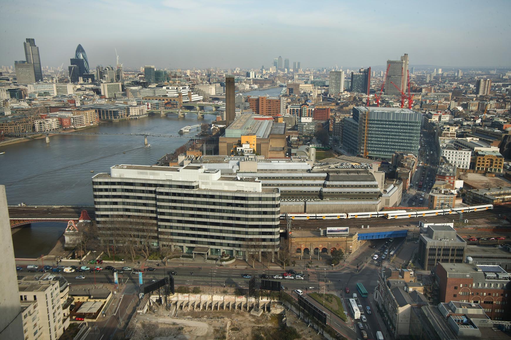
EAW043631 ENGLAND (1952). Bankside Power Station under construction and the surrounding area, The Borough, 1952
    © Hawlfraint cyfranwyr OpenStreetMap a thrwyddedwyd gan yr OpenStreetMap Foundation. 2025. Trwyddedir y gartograffeg fel CC BY-SA.
  
Delweddau cyfagos (21)
Manylion
| Pennawd | [EAW043631] Bankside Power Station under construction and the surrounding area, The Borough, 1952 | 
| Cyfeirnod | EAW043631 | 
| Dyddiad | 4-July-1952 | 
| Dolen | |
| Enw lle | THE BOROUGH | 
| Plwyf | |
| Ardal | |
| Gwlad | ENGLAND | 
| Dwyreiniad / Gogleddiad | 532018, 180323 | 
| Hydred / Lledred | -0.097565223955304, 51.505915151147 | 
| Cyfeirnod Grid Cenedlaethol | TQ320803 | 
Pinnau
|  Site of Borough Road Station (1864-1907) |   Leslie B | Saturday 22nd of January 2022 09:22:21 PM | 
|  Blackfriars Road |   brianbeckett | Monday 13th of October 2014 10:59:20 PM | 
|  Royal Eye Hospital, St Georges Circus |   brianbeckett | Monday 13th of October 2014 10:58:42 PM | 
|  Bomb damaged Spurgeons Tabanacle |   brianbeckett | Monday 13th of October 2014 10:57:28 PM | 
|  Trocodero cinema |   brianbeckett | Monday 13th of October 2014 10:55:51 PM | 
|  Elephan & Castle |   brianbeckett | Monday 13th of October 2014 10:55:01 PM | 
|   Alan McFaden | Saturday 9th of August 2014 06:12:27 PM | |
|  Evelina Children's Hospital |   courage | Monday 21st of July 2014 09:19:22 AM | 
|  Southwark Bridge Road |   courage | Monday 21st of July 2014 09:18:08 AM | 
|  Anchor Terrace |   courage | Monday 21st of July 2014 09:17:33 AM | 
|  The Anchor Brewery site, operated by Barclay, Perkins & Co. |   courage | Monday 21st of July 2014 09:17:03 AM | 
|   Alan McFaden | Tuesday 10th of June 2014 09:43:31 PM | |
|   Alan McFaden | Tuesday 10th of June 2014 09:42:48 PM | |
|   Alan McFaden | Tuesday 10th of June 2014 09:41:40 PM | |
|   Alan McFaden | Tuesday 10th of June 2014 09:40:44 PM | |
|   Alan McFaden | Tuesday 10th of June 2014 09:37:57 PM | |
|   Alan McFaden | Tuesday 10th of June 2014 09:37:01 PM | |
|   Alan McFaden | Tuesday 10th of June 2014 09:35:54 PM | |
|   Alan McFaden | Tuesday 10th of June 2014 09:34:44 PM | 
Cyfraniadau Grŵp
|   Bankside Area from the Kings Reach Tower 2006 |   Alan McFaden | Saturday 9th of August 2014 06:07:03 PM | 
 
             
  ![[EAW043631] Bankside Power Station under construction and the surrounding area, The Borough, 1952](http://britainfromabove.org.uk/sites/all/libraries/aerofilms-images/public/100x100/EAW/043/EAW043631.jpg) 
  
                                          ![[EAW028770] Southwark Street, Bankside Power Station under construction and environs, The Borough, 1950. This image was marked by Aerofilms Ltd for photo editing.](http://britainfromabove.org.uk/sites/all/libraries/aerofilms-images/public/100x100/EAW/028/EAW028770.jpg) 
 ![[EAW028771] Southwark Street, Blackfriars Bridge and environs, The Borough, 1950. This image was marked by Aerofilms Ltd for photo editing.](http://britainfromabove.org.uk/sites/all/libraries/aerofilms-images/public/100x100/EAW/028/EAW028771.jpg) 
 ![[EAW028767] Southwark Street from Great Guildford Street to Hopton Street, The Borough, 1950. This image was marked by Aerofilms Ltd for photo editing.](http://britainfromabove.org.uk/sites/all/libraries/aerofilms-images/public/100x100/EAW/028/EAW028767.jpg) 
 ![[EAW028765] Suffolk Street, Sumner Street and environs, The Borough, 1950. This image was marked by Aerofilms Ltd for photo editing.](http://britainfromabove.org.uk/sites/all/libraries/aerofilms-images/public/100x100/EAW/028/EAW028765.jpg) 
 ![[EAW041953] Bankside Power Station under construction, The Borough, 1952](http://britainfromabove.org.uk/sites/all/libraries/aerofilms-images/public/100x100/EAW/041/EAW041953.jpg) 
 ![[EAW028764] Southwark Street from Great Guildford Street to Hopton Street, The Borough, 1950. This image was marked by Aerofilms Ltd for photo editing.](http://britainfromabove.org.uk/sites/all/libraries/aerofilms-images/public/100x100/EAW/028/EAW028764.jpg) 
 ![[EAW043634] Bankside Power Station under construction and Blackfriars Bridge, The Borough, 1952](http://britainfromabove.org.uk/sites/all/libraries/aerofilms-images/public/100x100/EAW/043/EAW043634.jpg) 
 ![[EAW041951] Bankside Power Station under construction, The Borough, 1952](http://britainfromabove.org.uk/sites/all/libraries/aerofilms-images/public/100x100/EAW/041/EAW041951.jpg) 
 ![[EAW041955] Bankside Power Station under construction, The Borough, 1952](http://britainfromabove.org.uk/sites/all/libraries/aerofilms-images/public/100x100/EAW/041/EAW041955.jpg) 
 ![[EAW041952] Bankside Power Station under construction, The Borough, 1952](http://britainfromabove.org.uk/sites/all/libraries/aerofilms-images/public/100x100/EAW/041/EAW041952.jpg) 
 ![[EAW028768] The area around Southwark Street between Blackfriars Road and Southwark Bridge Road, The Borough, 1950. This image was marked by Aerofilms Ltd for photo editing.](http://britainfromabove.org.uk/sites/all/libraries/aerofilms-images/public/100x100/EAW/028/EAW028768.jpg) 
 ![[EAW041954] Bankside Power Station under construction, The Borough, 1952](http://britainfromabove.org.uk/sites/all/libraries/aerofilms-images/public/100x100/EAW/041/EAW041954.jpg) 
 ![[EAW043633] Bankside Power Station under construction and the surrounding area, The Borough, 1952](http://britainfromabove.org.uk/sites/all/libraries/aerofilms-images/public/100x100/EAW/043/EAW043633.jpg) 
 ![[EAW028766] The Ewer Street Grand Vitesse Depot, Lavington Street, Southwark Street and environs, The Borough, 1950. This image was marked by Aerofilms Ltd for photo editing.](http://britainfromabove.org.uk/sites/all/libraries/aerofilms-images/public/100x100/EAW/028/EAW028766.jpg) 
 ![[EAW028772] Bankside Power Station under construction and environs, The Borough, 1950. This image was marked by Aerofilms Ltd for photo editing.](http://britainfromabove.org.uk/sites/all/libraries/aerofilms-images/public/100x100/EAW/028/EAW028772.jpg) 
 ![[EAW028773] The Ewer Street Grand Vitesse Depot, Lavington Street, Southwark Street and environs, The Borough, 1950. This image was marked by Aerofilms Ltd for photo editing.](http://britainfromabove.org.uk/sites/all/libraries/aerofilms-images/public/100x100/EAW/028/EAW028773.jpg) 
 ![[EAW028769] Great Suffolk Street and environs, The Borough, 1950. This image was marked by Aerofilms Ltd for photo editing.](http://britainfromabove.org.uk/sites/all/libraries/aerofilms-images/public/100x100/EAW/028/EAW028769.jpg) 
 ![[EAW043632] Bankside Power Station under construction and Blackfriars Bridge, The Borough, 1952](http://britainfromabove.org.uk/sites/all/libraries/aerofilms-images/public/100x100/EAW/043/EAW043632.jpg) 
 ![[EAW000519] Blackfriars Bridge and Station and the city, The Borough, from the south-east, 1946](http://britainfromabove.org.uk/sites/all/libraries/aerofilms-images/public/100x100/EAW/000/EAW000519.jpg) 
 ![[EPW060802] Lambeth, Bermondsey and the River Thames from Westminster Bridge to London Bridge, London, 1939](http://britainfromabove.org.uk/sites/all/libraries/aerofilms-images/public/100x100/EPW/060/EPW060802.jpg) 


