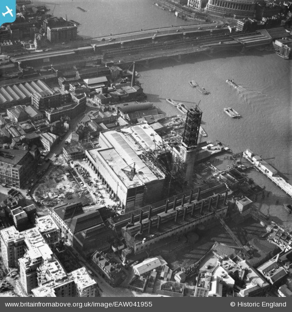
EAW041955 ENGLAND (1952). Bankside Power Station under construction, The Borough, 1952
    © Hawlfraint cyfranwyr OpenStreetMap a thrwyddedwyd gan yr OpenStreetMap Foundation. 2025. Trwyddedir y gartograffeg fel CC BY-SA.
  
Delweddau cyfagos (18)
Manylion
| Pennawd | [EAW041955] Bankside Power Station under construction, The Borough, 1952 | 
| Cyfeirnod | EAW041955 | 
| Dyddiad | 14-March-1952 | 
| Dolen | |
| Enw lle | THE BOROUGH | 
| Plwyf | |
| Ardal | |
| Gwlad | ENGLAND | 
| Dwyreiniad / Gogleddiad | 531976, 180469 | 
| Hydred / Lledred | -0.098115454443428, 51.507237143539 | 
| Cyfeirnod Grid Cenedlaethol | TQ320805 | 
Pinnau
|   Alan McFaden | Wednesday 14th of May 2014 09:29:28 AM | |
|   Alan McFaden | Tuesday 13th of May 2014 11:10:56 PM | |
|   Alan McFaden | Tuesday 13th of May 2014 11:07:21 PM | |
|   Alan McFaden | Tuesday 13th of May 2014 11:06:33 PM | |
|   Alan McFaden | Tuesday 13th of May 2014 11:05:04 PM | |
|   Alan McFaden | Tuesday 13th of May 2014 11:03:22 PM | 
Cyfraniadau Grŵp
| Bankside Power Station now Tate Modern from St. Paul's Cathedral looking south 07/01/2008 | Class31 | Tuesday 13th of May 2014 08:32:28 AM | 
 
             
  ![[EAW041955] Bankside Power Station under construction, The Borough, 1952](http://britainfromabove.org.uk/sites/all/libraries/aerofilms-images/public/100x100/EAW/041/EAW041955.jpg) 
  
                                          ![[EAW041951] Bankside Power Station under construction, The Borough, 1952](http://britainfromabove.org.uk/sites/all/libraries/aerofilms-images/public/100x100/EAW/041/EAW041951.jpg) 
 ![[EAW041952] Bankside Power Station under construction, The Borough, 1952](http://britainfromabove.org.uk/sites/all/libraries/aerofilms-images/public/100x100/EAW/041/EAW041952.jpg) 
 ![[EAW041954] Bankside Power Station under construction, The Borough, 1952](http://britainfromabove.org.uk/sites/all/libraries/aerofilms-images/public/100x100/EAW/041/EAW041954.jpg) 
 ![[EAW043634] Bankside Power Station under construction and Blackfriars Bridge, The Borough, 1952](http://britainfromabove.org.uk/sites/all/libraries/aerofilms-images/public/100x100/EAW/043/EAW043634.jpg) 
 ![[EAW043633] Bankside Power Station under construction and the surrounding area, The Borough, 1952](http://britainfromabove.org.uk/sites/all/libraries/aerofilms-images/public/100x100/EAW/043/EAW043633.jpg) 
 ![[EAW041953] Bankside Power Station under construction, The Borough, 1952](http://britainfromabove.org.uk/sites/all/libraries/aerofilms-images/public/100x100/EAW/041/EAW041953.jpg) 
 ![[EAW043632] Bankside Power Station under construction and Blackfriars Bridge, The Borough, 1952](http://britainfromabove.org.uk/sites/all/libraries/aerofilms-images/public/100x100/EAW/043/EAW043632.jpg) 
 ![[EAW000519] Blackfriars Bridge and Station and the city, The Borough, from the south-east, 1946](http://britainfromabove.org.uk/sites/all/libraries/aerofilms-images/public/100x100/EAW/000/EAW000519.jpg) 
 ![[EAW028772] Bankside Power Station under construction and environs, The Borough, 1950. This image was marked by Aerofilms Ltd for photo editing.](http://britainfromabove.org.uk/sites/all/libraries/aerofilms-images/public/100x100/EAW/028/EAW028772.jpg) 
 ![[EAW028770] Southwark Street, Bankside Power Station under construction and environs, The Borough, 1950. This image was marked by Aerofilms Ltd for photo editing.](http://britainfromabove.org.uk/sites/all/libraries/aerofilms-images/public/100x100/EAW/028/EAW028770.jpg) 
 ![[EAW043631] Bankside Power Station under construction and the surrounding area, The Borough, 1952](http://britainfromabove.org.uk/sites/all/libraries/aerofilms-images/public/100x100/EAW/043/EAW043631.jpg) 
 ![[EAW028768] The area around Southwark Street between Blackfriars Road and Southwark Bridge Road, The Borough, 1950. This image was marked by Aerofilms Ltd for photo editing.](http://britainfromabove.org.uk/sites/all/libraries/aerofilms-images/public/100x100/EAW/028/EAW028768.jpg) 
 ![[EAW028765] Suffolk Street, Sumner Street and environs, The Borough, 1950. This image was marked by Aerofilms Ltd for photo editing.](http://britainfromabove.org.uk/sites/all/libraries/aerofilms-images/public/100x100/EAW/028/EAW028765.jpg) 
 ![[EAW028764] Southwark Street from Great Guildford Street to Hopton Street, The Borough, 1950. This image was marked by Aerofilms Ltd for photo editing.](http://britainfromabove.org.uk/sites/all/libraries/aerofilms-images/public/100x100/EAW/028/EAW028764.jpg) 
 ![[EAW028771] Southwark Street, Blackfriars Bridge and environs, The Borough, 1950. This image was marked by Aerofilms Ltd for photo editing.](http://britainfromabove.org.uk/sites/all/libraries/aerofilms-images/public/100x100/EAW/028/EAW028771.jpg) 
 ![[EAW028769] Great Suffolk Street and environs, The Borough, 1950. This image was marked by Aerofilms Ltd for photo editing.](http://britainfromabove.org.uk/sites/all/libraries/aerofilms-images/public/100x100/EAW/028/EAW028769.jpg) 
 ![[EPW005135] Blackfriars Bridge, London, 1920](http://britainfromabove.org.uk/sites/all/libraries/aerofilms-images/public/100x100/EPW/005/EPW005135.jpg) 
 
 Sumner Street
 Sumner Street


