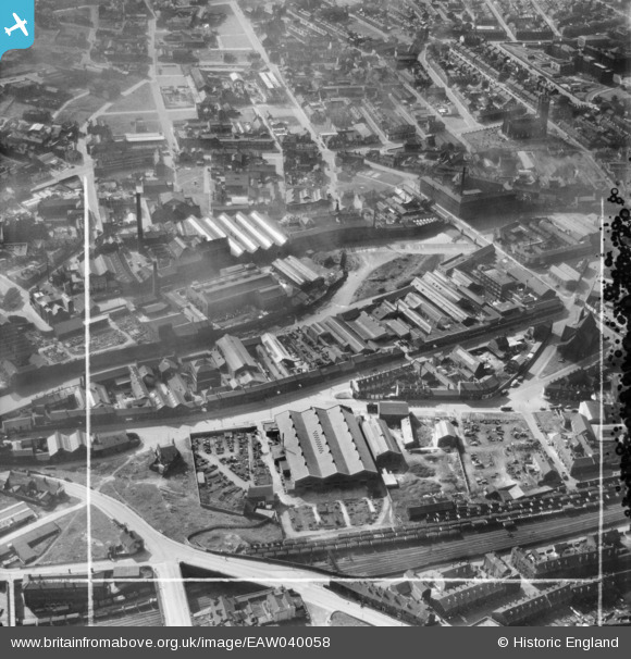
EAW040058 ENGLAND (1951). The Neepsend Steel and Tool Corporation Works off Mowbray Street and environs, Sheffield, 1951. This image was marked by Aerofilms Ltd for photo editing.
© Hawlfraint cyfranwyr OpenStreetMap a thrwyddedwyd gan yr OpenStreetMap Foundation. 2026. Trwyddedir y gartograffeg fel CC BY-SA.
Delweddau cyfagos (16)
Manylion
| Pennawd | [EAW040058] The Neepsend Steel and Tool Corporation Works off Mowbray Street and environs, Sheffield, 1951. This image was marked by Aerofilms Ltd for photo editing. |
| Cyfeirnod | EAW040058 |
| Dyddiad | 17-September-1951 |
| Dolen | |
| Enw lle | SHEFFIELD |
| Plwyf | |
| Ardal | |
| Gwlad | ENGLAND |
| Dwyreiniad / Gogleddiad | 435148, 388263 |
| Hydred / Lledred | -1.4714408001148, 53.38977176823 |
| Cyfeirnod Grid Cenedlaethol | SK351883 |
Pinnau

Kerry |
Wednesday 16th of April 2025 10:45:07 PM | |

travellingpass |
Wednesday 15th of May 2024 07:21:31 AM | |

LWSWFC |
Tuesday 26th of December 2023 08:14:59 PM | |

travellingpass |
Thursday 24th of November 2016 09:57:05 PM | |

Class31 |
Friday 13th of May 2016 10:32:14 PM | |

travellingpass |
Wednesday 10th of December 2014 10:03:13 AM | |

travellingpass |
Wednesday 10th of December 2014 10:01:44 AM | |

Anil |
Friday 6th of June 2014 07:30:04 PM | |

Anil |
Friday 6th of June 2014 07:25:23 PM | |

Anil |
Friday 6th of June 2014 07:15:07 PM | |

Anil |
Friday 6th of June 2014 07:14:23 PM |
Cyfraniadau Grŵp
Grade II* Globe Works, Penistone Road, Sheffield, 14/07/2015 |

Class31 |
Friday 13th of May 2016 10:26:31 PM |


![[EAW040058] The Neepsend Steel and Tool Corporation Works off Mowbray Street and environs, Sheffield, 1951. This image was marked by Aerofilms Ltd for photo editing.](http://britainfromabove.org.uk/sites/all/libraries/aerofilms-images/public/100x100/EAW/040/EAW040058.jpg)
![[EAW038435] The W. A. Tyzack & Co Ltd Horseman Works, Kelham Island and environs, Sheffield, 1951. This image has been produced from a print marked by Aerofilms Ltd for photo editing.](http://britainfromabove.org.uk/sites/all/libraries/aerofilms-images/public/100x100/EAW/038/EAW038435.jpg)
![[EAW038434] The W. A. Tyzack & Co Ltd Horseman Works, Kelham Island and environs, Sheffield, 1951. This image has been produced from a print marked by Aerofilms Ltd for photo editing.](http://britainfromabove.org.uk/sites/all/libraries/aerofilms-images/public/100x100/EAW/038/EAW038434.jpg)
![[EAW038429] The W. A. Tyzack & Co Ltd Horseman Works, Kelham Island and environs, Sheffield, 1951. This image has been produced from a print marked by Aerofilms Ltd for photo editing.](http://britainfromabove.org.uk/sites/all/libraries/aerofilms-images/public/100x100/EAW/038/EAW038429.jpg)
![[EAW038428] The W. A. Tyzack & Co Ltd Horseman Works and environs, Sheffield, 1951. This image has been produced from a print marked by Aerofilms Ltd for photo editing.](http://britainfromabove.org.uk/sites/all/libraries/aerofilms-images/public/100x100/EAW/038/EAW038428.jpg)
![[EAW038433] The W. A. Tyzack & Co Ltd Horseman Works, Kelham Island and environs, Sheffield, 1951. This image has been produced from a print marked by Aerofilms Ltd for photo editing.](http://britainfromabove.org.uk/sites/all/libraries/aerofilms-images/public/100x100/EAW/038/EAW038433.jpg)
![[EAW038432] The W. A. Tyzack & Co Ltd Horseman Works, Kelham Island and environs, Sheffield, 1951. This image has been produced from a print marked by Aerofilms Ltd for photo editing.](http://britainfromabove.org.uk/sites/all/libraries/aerofilms-images/public/100x100/EAW/038/EAW038432.jpg)
![[EAW040055] The Neepsend Steel and Tool Corporation Works off Mowbray Street and environs, Sheffield, 1951. This image was marked by Aerofilms Ltd for photo editing.](http://britainfromabove.org.uk/sites/all/libraries/aerofilms-images/public/100x100/EAW/040/EAW040055.jpg)
![[EAW038430] The W. A. Tyzack & Co Ltd Horseman Works and environs, Sheffield, 1951. This image has been produced from a print marked by Aerofilms Ltd for photo editing.](http://britainfromabove.org.uk/sites/all/libraries/aerofilms-images/public/100x100/EAW/038/EAW038430.jpg)
![[EAW040057] The Neepsend Steel and Tool Corporation Works off Mowbray Street and environs, Sheffield, 1951. This image was marked by Aerofilms Ltd for photo editing.](http://britainfromabove.org.uk/sites/all/libraries/aerofilms-images/public/100x100/EAW/040/EAW040057.jpg)
![[EAW040054] The Neepsend Steel and Tool Corporation Works off Mowbray Street and environs, Sheffield, 1951. This image was marked by Aerofilms Ltd for photo editing.](http://britainfromabove.org.uk/sites/all/libraries/aerofilms-images/public/100x100/EAW/040/EAW040054.jpg)
![[EAW040056] The Neepsend Steel and Tool Corporation Works off Mowbray Street and environs, Sheffield, 1951. This image was marked by Aerofilms Ltd for photo editing.](http://britainfromabove.org.uk/sites/all/libraries/aerofilms-images/public/100x100/EAW/040/EAW040056.jpg)
![[EAW040059] The Neepsend Steel and Tool Corporation Works off Mowbray Street, Woodside and St Michael & All Angels' Church, Sheffield, 1951. This image was marked by Aerofilms Ltd for photo editing.](http://britainfromabove.org.uk/sites/all/libraries/aerofilms-images/public/100x100/EAW/040/EAW040059.jpg)
![[EAW040051] St Michael & All Angels' Church, Burton Road and the surrounding area, Sheffield, 1951. This image was marked by Aerofilms Ltd for photo editing.](http://britainfromabove.org.uk/sites/all/libraries/aerofilms-images/public/100x100/EAW/040/EAW040051.jpg)
![[EAW040052] St Michael & All Angels' Church, Burton Road and the surrounding area, Sheffield, 1951. This image was marked by Aerofilms Ltd for photo editing.](http://britainfromabove.org.uk/sites/all/libraries/aerofilms-images/public/100x100/EAW/040/EAW040052.jpg)
![[EAW040048] St Michael & All Angels' Church, Burton Road and the surrounding area, Sheffield, 1951. This image was marked by Aerofilms Ltd for photo editing.](http://britainfromabove.org.uk/sites/all/libraries/aerofilms-images/public/100x100/EAW/040/EAW040048.jpg)