
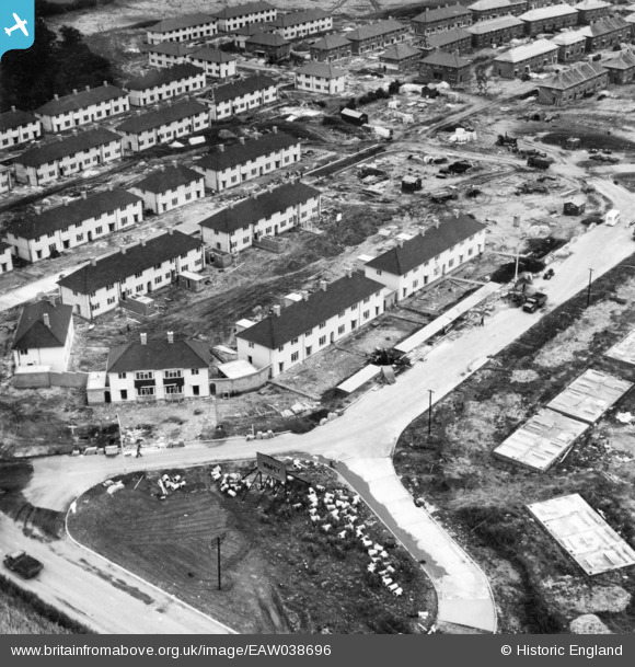
EAW038696 ENGLAND (1951). Housing construction and development around Farnborough Road on the Clifton Estate, Clifton, 1951. This image has been produced from a print.
© Hawlfraint cyfranwyr OpenStreetMap a thrwyddedwyd gan yr OpenStreetMap Foundation. 2026. Trwyddedir y gartograffeg fel CC BY-SA.
Delweddau cyfagos (16)
EAW038696

EAW038697

EAW038699

EAW038700

EAW038698

EAW038705

EAW038707

EAW038703

EAW038704

EAW038701

EAW038706

EAW048679

EAW048682

EAW038702

EAW048687

EAW048680

Manylion
| Pennawd | [EAW038696] Housing construction and development around Farnborough Road on the Clifton Estate, Clifton, 1951. This image has been produced from a print. |
| Cyfeirnod | EAW038696 |
| Dyddiad | 14-August-1951 |
| Dolen | |
| Enw lle | CLIFTON |
| Plwyf | |
| Ardal | |
| Gwlad | ENGLAND |
| Dwyreiniad / Gogleddiad | 455511, 335621 |
| Hydred / Lledred | -1.1743767146965, 52.914822403721 |
| Cyfeirnod Grid Cenedlaethol | SK555356 |
Pinnau

KC |
Sunday 19th of October 2025 01:25:25 PM | |
|
KC |
Friday 25th of August 2023 06:21:19 PM | |

Billy Turner |
Monday 22nd of May 2017 04:02:25 PM |
