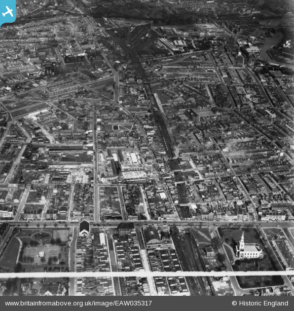
EAW035317 ENGLAND (1951). East India Dock Road, Kerbey Street and environs, Poplar, 1951. This image has been produced from a print marked by Aerofilms Ltd for photo editing.
    © Hawlfraint cyfranwyr OpenStreetMap a thrwyddedwyd gan yr OpenStreetMap Foundation. 2025. Trwyddedir y gartograffeg fel CC BY-SA.
  
Delweddau cyfagos (7)
Manylion
| Pennawd | [EAW035317] East India Dock Road, Kerbey Street and environs, Poplar, 1951. This image has been produced from a print marked by Aerofilms Ltd for photo editing. | 
| Cyfeirnod | EAW035317 | 
| Dyddiad | 10-May-1951 | 
| Dolen | |
| Enw lle | POPLAR | 
| Plwyf | |
| Ardal | |
| Gwlad | ENGLAND | 
| Dwyreiniad / Gogleddiad | 537877, 181281 | 
| Hydred / Lledred | -0.012813357168563, 51.513125478972 | 
| Cyfeirnod Grid Cenedlaethol | TQ379813 | 
Pinnau
|  Poplar police station. Demolished 1971. |   Grollo | Monday 26th of June 2017 10:27:21 PM | 
|  Spratt's Patent Pet Food factory |   Leslie B | Tuesday 5th of April 2016 11:33:59 PM | 
|  Spratt's Patent Pet Food factory |   Leslie B | Tuesday 5th of April 2016 11:33:59 PM | 
|  Closed Poplar station. Closed to passengers in 1944 and the replacement bus ceased in 1945. The most bombed station in London.
Now the site of All Saints DLR station.
More here: http://www.disused-stations.org.uk/p/poplar_east_india_road/index.shtml |   Leslie B | Tuesday 5th of April 2016 11:32:30 PM | 
|  South Bromley station, closed in 1944, and the replacement bus service was withdrawn on 23/4/1945. |   Leslie B | Tuesday 5th of April 2016 11:29:57 PM | 
 
             
  ![[EAW035317] East India Dock Road, Kerbey Street and environs, Poplar, 1951. This image has been produced from a print marked by Aerofilms Ltd for photo editing.](http://britainfromabove.org.uk/sites/all/libraries/aerofilms-images/public/100x100/EAW/035/EAW035317.jpg) 
  
                                          ![[EAW035316] Kerbey Street and environs, Poplar, 1951. This image has been produced from a print.](http://britainfromabove.org.uk/sites/all/libraries/aerofilms-images/public/100x100/EAW/035/EAW035316.jpg) 
 ![[EAW035318] All Saints Church, Chrisp Street and environs, Poplar, 1951. This image has been produced from a print marked by Aerofilms Ltd for photo editing.](http://britainfromabove.org.uk/sites/all/libraries/aerofilms-images/public/100x100/EAW/035/EAW035318.jpg) 
 ![[EAW035319] Ida Street, Chrisp Street and environs, Poplar, 1951. This image has been produced from a print.](http://britainfromabove.org.uk/sites/all/libraries/aerofilms-images/public/100x100/EAW/035/EAW035319.jpg) 
 ![[EAW035320] Market Square, Ricardo Street and environs, Poplar, 1951. This image has been produced from a print marked by Aerofilms Ltd for photo editing.](http://britainfromabove.org.uk/sites/all/libraries/aerofilms-images/public/100x100/EAW/035/EAW035320.jpg) 
 ![[EAW000644] The bomb damaged residential area at Bromley, Poplar, 1946](http://britainfromabove.org.uk/sites/all/libraries/aerofilms-images/public/100x100/EAW/000/EAW000644.jpg) 
 ![[EAW000653] The residential area at Bromley, South Bromley, 1946](http://britainfromabove.org.uk/sites/all/libraries/aerofilms-images/public/100x100/EAW/000/EAW000653.jpg)