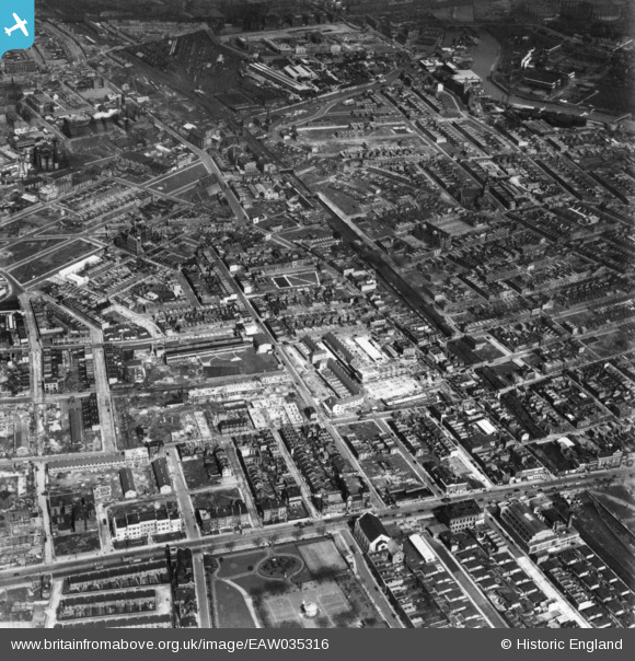
EAW035316 ENGLAND (1951). Kerbey Street and environs, Poplar, 1951. This image has been produced from a print.
    © Hawlfraint cyfranwyr OpenStreetMap a thrwyddedwyd gan yr OpenStreetMap Foundation. 2025. Trwyddedir y gartograffeg fel CC BY-SA.
  
Delweddau cyfagos (6)
Manylion
| Pennawd | [EAW035316] Kerbey Street and environs, Poplar, 1951. This image has been produced from a print. | 
| Cyfeirnod | EAW035316 | 
| Dyddiad | 10-May-1951 | 
| Dolen | |
| Enw lle | POPLAR | 
| Plwyf | |
| Ardal | |
| Gwlad | ENGLAND | 
| Dwyreiniad / Gogleddiad | 537815, 181306 | 
| Hydred / Lledred | -0.013696594616911, 51.513365285498 | 
| Cyfeirnod Grid Cenedlaethol | TQ378813 | 
Pinnau
|  St Michael and All Angels' Church |   Robin | Saturday 29th of June 2019 04:34:28 PM | 
|  Chimney lettering says "SPRATT'S" |   Robin | Saturday 29th of June 2019 03:52:51 PM | 
|  George Green's School |   Robin | Saturday 29th of June 2019 03:41:55 PM | 
|  East India Hall, also known as Poplar Baths |   Robin | Saturday 29th of June 2019 03:41:10 PM | 
|  Site of Poplar East India Road Station, already closed (1945) when this photograph was taken. Now All Saints Station, DLR |   Robin | Saturday 29th of June 2019 03:36:56 PM | 
|  Bygrove Street |   Robin | Saturday 29th of June 2019 03:26:35 PM | 
|  River Lee / Bow Creek |   Robin | Saturday 29th of June 2019 03:03:39 PM | 
 
             
  ![[EAW035316] Kerbey Street and environs, Poplar, 1951. This image has been produced from a print.](http://britainfromabove.org.uk/sites/all/libraries/aerofilms-images/public/100x100/EAW/035/EAW035316.jpg) 
  
                                          ![[EAW035317] East India Dock Road, Kerbey Street and environs, Poplar, 1951. This image has been produced from a print marked by Aerofilms Ltd for photo editing.](http://britainfromabove.org.uk/sites/all/libraries/aerofilms-images/public/100x100/EAW/035/EAW035317.jpg) 
 ![[EAW035319] Ida Street, Chrisp Street and environs, Poplar, 1951. This image has been produced from a print.](http://britainfromabove.org.uk/sites/all/libraries/aerofilms-images/public/100x100/EAW/035/EAW035319.jpg) 
 ![[EAW035318] All Saints Church, Chrisp Street and environs, Poplar, 1951. This image has been produced from a print marked by Aerofilms Ltd for photo editing.](http://britainfromabove.org.uk/sites/all/libraries/aerofilms-images/public/100x100/EAW/035/EAW035318.jpg) 
 ![[EAW035320] Market Square, Ricardo Street and environs, Poplar, 1951. This image has been produced from a print marked by Aerofilms Ltd for photo editing.](http://britainfromabove.org.uk/sites/all/libraries/aerofilms-images/public/100x100/EAW/035/EAW035320.jpg) 
 ![[EAW000644] The bomb damaged residential area at Bromley, Poplar, 1946](http://britainfromabove.org.uk/sites/all/libraries/aerofilms-images/public/100x100/EAW/000/EAW000644.jpg)