
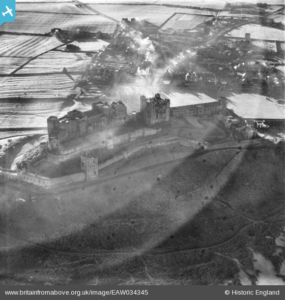
EAW034345 ENGLAND (1950). Bamburgh Castle overlooking the village, Bamburgh, 1950. This image has been produced from a print.
© Hawlfraint cyfranwyr OpenStreetMap a thrwyddedwyd gan yr OpenStreetMap Foundation. 2026. Trwyddedir y gartograffeg fel CC BY-SA.
Delweddau cyfagos (12)
EAW034345

EAW006093

EAW006091

EAW006089

EAW006090

EAW034346

EAW034342

EAW034344

EAW034343

EAW006088

EAW006092

EAW034347

Manylion
| Pennawd | [EAW034345] Bamburgh Castle overlooking the village, Bamburgh, 1950. This image has been produced from a print. |
| Cyfeirnod | EAW034345 |
| Dyddiad | 25-November-1950 |
| Dolen | |
| Enw lle | BAMBURGH |
| Plwyf | BAMBURGH |
| Ardal | |
| Gwlad | ENGLAND |
| Dwyreiniad / Gogleddiad | 418359, 635111 |
| Hydred / Lledred | -1.7085382699646, 55.609256680252 |
| Cyfeirnod Grid Cenedlaethol | NU184351 |
Pinnau
 |

melgibbs |
Monday 11th of April 2016 04:50:36 PM |
|
melgibbs |
Friday 16th of October 2015 06:11:44 PM | |
 |
melgibbs |
Wednesday 22nd of October 2014 07:30:02 PM |
Cyfraniadau Grŵp
Shipwrecks were common on this stretch of coastline and a Dr John Sharp (1722 - 1792) who was resident at the castle founded what is recognised as the first coastguard system in the world. More can be read at http://bamburgh.org.uk/news/did-bamburgh-shipwreck-inspire-first-coastguards-/ and http://www.bamburghcastle.com/history_more.php?id=57 |
melgibbs |
Sunday 30th of October 2016 06:43:42 PM |