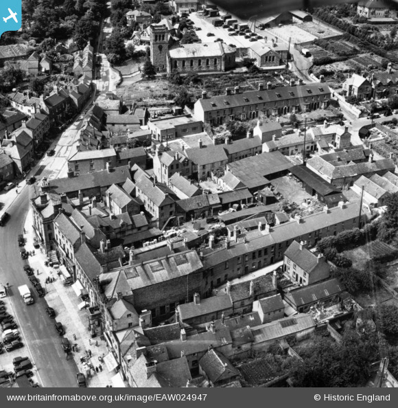
EAW024947 ENGLAND (1949). Town Hall Yard, the Church of St John the Baptist and environs, Ashbourne, 1949. This image has been produced from a print.
© Hawlfraint cyfranwyr OpenStreetMap a thrwyddedwyd gan yr OpenStreetMap Foundation. 2026. Trwyddedir y gartograffeg fel CC BY-SA.
Delweddau cyfagos (10)
Manylion
| Pennawd | [EAW024947] Town Hall Yard, the Church of St John the Baptist and environs, Ashbourne, 1949. This image has been produced from a print. |
| Cyfeirnod | EAW024947 |
| Dyddiad | 21-July-1949 |
| Dolen | |
| Enw lle | ASHBOURNE |
| Plwyf | ASHBOURNE |
| Ardal | |
| Gwlad | ENGLAND |
| Dwyreiniad / Gogleddiad | 418067, 346867 |
| Hydred / Lledred | -1.7306454802337, 53.018490471366 |
| Cyfeirnod Grid Cenedlaethol | SK181469 |
Pinnau
Byddwch y cyntaf i ychwanegu sylw at y ddelwedd hon!


![[EAW024947] Town Hall Yard, the Church of St John the Baptist and environs, Ashbourne, 1949. This image has been produced from a print.](http://britainfromabove.org.uk/sites/all/libraries/aerofilms-images/public/100x100/EAW/024/EAW024947.jpg)
![[EAW024952] The town centre, Ashbourne, 1949. This image was marked by Aerofilms Ltd for photo editing.](http://britainfromabove.org.uk/sites/all/libraries/aerofilms-images/public/100x100/EAW/024/EAW024952.jpg)
![[EAW024944] The Market Place and environs, Ashbourne, 1949. This image has been produced from a print.](http://britainfromabove.org.uk/sites/all/libraries/aerofilms-images/public/100x100/EAW/024/EAW024944.jpg)
![[EAW024945] The Market Place and environs, Ashbourne, 1949. This image has been produced from a print marked by Aerofilms Ltd for photo editing.](http://britainfromabove.org.uk/sites/all/libraries/aerofilms-images/public/100x100/EAW/024/EAW024945.jpg)
![[EAW024951] The Town Hall, the Church of St John the Baptist and the Cattle Market, Ashbourne, 1949. This image was marked by Aerofilms Ltd for photo editing.](http://britainfromabove.org.uk/sites/all/libraries/aerofilms-images/public/100x100/EAW/024/EAW024951.jpg)
![[EAW024948] Town Hall Yard and environs, Ashbourne, 1949. This image has been produced from a print marked by Aerofilms Ltd for photo editing.](http://britainfromabove.org.uk/sites/all/libraries/aerofilms-images/public/100x100/EAW/024/EAW024948.jpg)
![[EAW024949] Town Hall Yard and the Market Place (site of), Ashbourne, 1949. This image has been produced from a damaged negative.](http://britainfromabove.org.uk/sites/all/libraries/aerofilms-images/public/100x100/EAW/024/EAW024949.jpg)
![[EAW024950] Town Hall Yard and the Market Place, Ashbourne, 1949. This image has been produced from a damaged negative.](http://britainfromabove.org.uk/sites/all/libraries/aerofilms-images/public/100x100/EAW/024/EAW024950.jpg)
![[EAW024953] The Market Place, the Church of John the Baptist and the Cattle Market, Ashbourne, 1949. This image was marked by Aerofilms Ltd for photo editing.](http://britainfromabove.org.uk/sites/all/libraries/aerofilms-images/public/100x100/EAW/024/EAW024953.jpg)
![[EAW024946] Town Hall Yard and environs, Ashbourne, 1949. This image has been produced from a print.](http://britainfromabove.org.uk/sites/all/libraries/aerofilms-images/public/100x100/EAW/024/EAW024946.jpg)