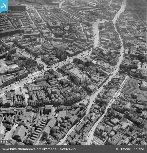
EAW024239 ENGLAND (1949). Humberstone Gate, Charles Street and the city centre, Leicester, 1949
© Hawlfraint cyfranwyr OpenStreetMap a thrwyddedwyd gan yr OpenStreetMap Foundation. 2026. Trwyddedir y gartograffeg fel CC BY-SA.
Delweddau cyfagos (28)
Manylion
| Pennawd | [EAW024239] Humberstone Gate, Charles Street and the city centre, Leicester, 1949 |
| Cyfeirnod | EAW024239 |
| Dyddiad | 27-June-1949 |
| Dolen | |
| Enw lle | LEICESTER |
| Plwyf | |
| Ardal | |
| Gwlad | ENGLAND |
| Dwyreiniad / Gogleddiad | 458882, 304605 |
| Hydred / Lledred | -1.1298239095383, 52.635644679391 |
| Cyfeirnod Grid Cenedlaethol | SK589046 |
Pinnau

Class31 |
Tuesday 5th of May 2015 12:55:07 PM | |

Class31 |
Tuesday 5th of May 2015 12:52:59 PM | |

Class31 |
Tuesday 5th of May 2015 12:51:24 PM | |

Class31 |
Tuesday 5th of May 2015 12:48:13 PM |


![[EAW024239] Humberstone Gate, Charles Street and the city centre, Leicester, 1949](http://britainfromabove.org.uk/sites/all/libraries/aerofilms-images/public/100x100/EAW/024/EAW024239.jpg)
![[EAW024244] Charles Street and the city centre, Leicester, 1949](http://britainfromabove.org.uk/sites/all/libraries/aerofilms-images/public/100x100/EAW/024/EAW024244.jpg)
![[EPW018422] Gallowtree Gate and environs, Leicester, 1927. This image has been produced from a print.](http://britainfromabove.org.uk/sites/all/libraries/aerofilms-images/public/100x100/EPW/018/EPW018422.jpg)
![[EAW024243] The Clock Tower, Humberstone Gate and the city centre, Leicester, 1949](http://britainfromabove.org.uk/sites/all/libraries/aerofilms-images/public/100x100/EAW/024/EAW024243.jpg)
![[EAW024242] Gallowtree Gate, Cheapside and the city centre, Leicester, 1949](http://britainfromabove.org.uk/sites/all/libraries/aerofilms-images/public/100x100/EAW/024/EAW024242.jpg)
![[EPW055011] Charles Street and the city centre, Leicester, 1937](http://britainfromabove.org.uk/sites/all/libraries/aerofilms-images/public/100x100/EPW/055/EPW055011.jpg)
![[EAW051834] The city centre around High Street and Humberstone Gate, Leicester, 1953](http://britainfromabove.org.uk/sites/all/libraries/aerofilms-images/public/100x100/EAW/051/EAW051834.jpg)
![[EPW018412] The city by the junction of Gallowtree Gate and Horsefair Street, Leicester, 1927. This image has been produced from a copy-negative.](http://britainfromabove.org.uk/sites/all/libraries/aerofilms-images/public/100x100/EPW/018/EPW018412.jpg)
![[EPW047643] The Clock Tower and the city centre, Leicester, 1935](http://britainfromabove.org.uk/sites/all/libraries/aerofilms-images/public/100x100/EPW/047/EPW047643.jpg)
![[EAW051831] The city centre around Lee Street and Humberstone Gate, Leicester, 1953](http://britainfromabove.org.uk/sites/all/libraries/aerofilms-images/public/100x100/EAW/051/EAW051831.jpg)
![[EPW047645] The city centre, Leicester, 1935](http://britainfromabove.org.uk/sites/all/libraries/aerofilms-images/public/100x100/EPW/047/EPW047645.jpg)
![[EPW047641] The Haymarket and city centre, Leicester, 1935](http://britainfromabove.org.uk/sites/all/libraries/aerofilms-images/public/100x100/EPW/047/EPW047641.jpg)
![[EPW055006] The Haymarket and the city centre, Leicester, 1937](http://britainfromabove.org.uk/sites/all/libraries/aerofilms-images/public/100x100/EPW/055/EPW055006.jpg)
![[EPW020895] The city centre, Leicester, 1928](http://britainfromabove.org.uk/sites/all/libraries/aerofilms-images/public/100x100/EPW/020/EPW020895.jpg)
![[EPW018431] The junction of Gallowtree Gate and Halford Street, Leicester, 1927](http://britainfromabove.org.uk/sites/all/libraries/aerofilms-images/public/100x100/EPW/018/EPW018431.jpg)
![[EAW024240] Charles Street, Granby Street and the city centre, Leicester, 1949](http://britainfromabove.org.uk/sites/all/libraries/aerofilms-images/public/100x100/EAW/024/EAW024240.jpg)
![[EPW018433] East Gates and environs, Leicester, 1927](http://britainfromabove.org.uk/sites/all/libraries/aerofilms-images/public/100x100/EPW/018/EPW018433.jpg)
![[EPW061213] Charles Street and environs, Leicester, 1939](http://britainfromabove.org.uk/sites/all/libraries/aerofilms-images/public/100x100/EPW/061/EPW061213.jpg)
![[EPW018436] Town Hall Square and environs, Leicester, 1927](http://britainfromabove.org.uk/sites/all/libraries/aerofilms-images/public/100x100/EPW/018/EPW018436.jpg)
![[EPW020892] The Town Square and city centre, Leicester, 1928](http://britainfromabove.org.uk/sites/all/libraries/aerofilms-images/public/100x100/EPW/020/EPW020892.jpg)
![[EPW018421] The Town Hall, Horsefair Street and environs, Leicester, 1927. This image has been produced from a print.](http://britainfromabove.org.uk/sites/all/libraries/aerofilms-images/public/100x100/EPW/018/EPW018421.jpg)
![[EPW055009] Charles Street, St George's Church and the city, Leicester, 1937](http://britainfromabove.org.uk/sites/all/libraries/aerofilms-images/public/100x100/EPW/055/EPW055009.jpg)
![[EAW052680] Arthur Foister and Sons Ltd (Cherub Ltd) Factory on Charles Street, Leicester, 1953. This image was marked by Aerofilms Ltd for photo editing.](http://britainfromabove.org.uk/sites/all/libraries/aerofilms-images/public/100x100/EAW/052/EAW052680.jpg)
![[EAW052674] Arthur Foister & Sons Ltd (Cherub Ltd) Factory on Charles Street, St George's Church and Rutland Street, Leicester, 1953. This image was marked by Aerofilms Ltd for photo editing.](http://britainfromabove.org.uk/sites/all/libraries/aerofilms-images/public/100x100/EAW/052/EAW052674.jpg)
![[EPW061211] The city centre, Leicester, 1939](http://britainfromabove.org.uk/sites/all/libraries/aerofilms-images/public/100x100/EPW/061/EPW061211.jpg)
![[EAW052676] Arthur Foister & Sons Ltd (Cherub Ltd) Factory on Charles Street and St George's Church, Leicester, 1953. This image was marked by Aerofilms Ltd for photo editing.](http://britainfromabove.org.uk/sites/all/libraries/aerofilms-images/public/100x100/EAW/052/EAW052676.jpg)
![[EAW052675] Arthur Foister & Sons Ltd (Cherub Ltd) Factory on Charles Street, Leicester, 1953. This image was marked by Aerofilms Ltd for photo editing.](http://britainfromabove.org.uk/sites/all/libraries/aerofilms-images/public/100x100/EAW/052/EAW052675.jpg)
![[EAW052679] Colton Street and Arthur Foister and Sons Ltd (Cherub Ltd) Factory on Charles Street, Leicester, 1953. This image was marked by Aerofilms Ltd for photo editing.](http://britainfromabove.org.uk/sites/all/libraries/aerofilms-images/public/100x100/EAW/052/EAW052679.jpg)