
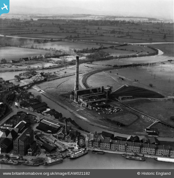
EAW021182 ENGLAND (1949). Castle Meads Power Station and environs, Gloucester, from the east, 1949. This image has been produced from a print.
© Hawlfraint cyfranwyr OpenStreetMap a thrwyddedwyd gan yr OpenStreetMap Foundation. 2026. Trwyddedir y gartograffeg fel CC BY-SA.
Delweddau cyfagos (23)
EAW021182

EAW021185

EAW021181

EAW012210

EAW012209

EPW037749

EAW021184

EAW021183

EAW012207

EPW024161

EAW012204

EAW012200

EAW012202

EAW018728

EPW037751

EPW037834

EPW048244

EPW037750

EPW024166

EAW012197

EPW024154

EPW037837

EAW021189

Manylion
| Pennawd | [EAW021182] Castle Meads Power Station and environs, Gloucester, from the east, 1949. This image has been produced from a print. |
| Cyfeirnod | EAW021182 |
| Dyddiad | 2-March-1949 |
| Dolen | |
| Enw lle | GLOUCESTER |
| Plwyf | |
| Ardal | |
| Gwlad | ENGLAND |
| Dwyreiniad / Gogleddiad | 382566, 218322 |
| Hydred / Lledred | -2.2532038881144, 51.862766178473 |
| Cyfeirnod Grid Cenedlaethol | SO826183 |
Pinnau
 |

Class31 |
Wednesday 3rd of June 2015 08:28:56 PM |