
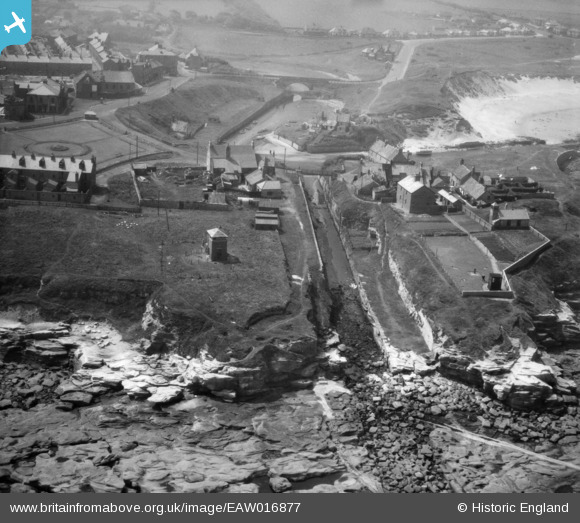
EAW016877 ENGLAND (1948). Seaton Sluice Harbour, Seaton Sluice, 1948
© Hawlfraint cyfranwyr OpenStreetMap a thrwyddedwyd gan yr OpenStreetMap Foundation. 2026. Trwyddedir y gartograffeg fel CC BY-SA.
Delweddau cyfagos (7)
EAW016877

EAW016882

EAW016881

EAW016879

EAW016880

EAW016878

EAW016855

Manylion
| Pennawd | [EAW016877] Seaton Sluice Harbour, Seaton Sluice, 1948 |
| Cyfeirnod | EAW016877 |
| Dyddiad | 24-June-1948 |
| Dolen | |
| Enw lle | SEATON SLUICE |
| Plwyf | SEATON VALLEY |
| Ardal | |
| Gwlad | ENGLAND |
| Dwyreiniad / Gogleddiad | 433875, 576807 |
| Hydred / Lledred | -1.4692731601867, 55.084485871045 |
| Cyfeirnod Grid Cenedlaethol | NZ339768 |
Pinnau

Matt Aldred edob.mattaldred.com |
Monday 30th of November 2020 06:56:44 PM | |
|
Matt Aldred edob.mattaldred.com |
Monday 30th of November 2020 06:55:14 PM | |
|
Matt Aldred edob.mattaldred.com |
Monday 30th of November 2020 06:47:11 PM | |
|
Matt Aldred edob.mattaldred.com |
Monday 30th of November 2020 06:47:05 PM | |

redmist |
Thursday 7th of November 2019 07:43:38 PM | |
|
Chris Kolonko |
Friday 15th of September 2017 10:07:01 PM | |
|
Al |
Friday 12th of December 2014 09:13:48 PM |
Cyfraniadau Grŵp
I believe this is an unrecorded Pillbox similar to the other variants in the area... .thoughts? |
Al |
Friday 12th of December 2014 09:15:40 PM |
Rocky Island on the right of the photo. The houses there were demolished at the end of the 1950s, early 1960s. |
Hugh402 |
Thursday 20th of February 2014 11:39:21 AM |