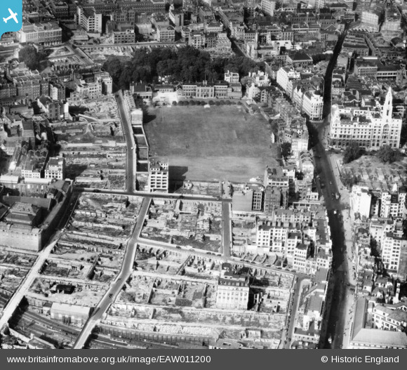
EAW011200 ENGLAND (1947). The New Artillery Ground and surrounding cleared sites following bomb damage, St Luke's, 1947
    © Hawlfraint cyfranwyr OpenStreetMap a thrwyddedwyd gan yr OpenStreetMap Foundation. 2025. Trwyddedir y gartograffeg fel CC BY-SA.
  
Delweddau cyfagos (10)
Manylion
| Pennawd | [EAW011200] The New Artillery Ground and surrounding cleared sites following bomb damage, St Luke's, 1947 | 
| Cyfeirnod | EAW011200 | 
| Dyddiad | 30-October-1947 | 
| Dolen | |
| Enw lle | ST LUKE'S | 
| Plwyf | |
| Ardal | |
| Gwlad | ENGLAND | 
| Dwyreiniad / Gogleddiad | 532672, 181978 | 
| Hydred / Lledred | -0.087523461871423, 51.520636235299 | 
| Cyfeirnod Grid Cenedlaethol | TQ327820 | 
Pinnau
|  Bunhill Row |   Smudger | Wednesday 23rd of October 2024 05:26:31 PM | 
|   Alan McFaden | Thursday 20th of November 2014 09:16:25 AM | |
| Class31 | Tuesday 8th of July 2014 05:31:18 PM | |
| Class31 | Tuesday 8th of July 2014 05:29:55 PM | |
| Class31 | Tuesday 8th of July 2014 05:08:35 PM | |
|   Alan McFaden | Friday 23rd of May 2014 06:10:58 PM | |
|   Alan McFaden | Friday 23rd of May 2014 06:10:19 PM | |
|   Alan McFaden | Friday 23rd of May 2014 06:09:27 PM | |
|  Tabernacle Street | Class31 | Monday 12th of May 2014 05:26:31 PM | 
|  City Road | Class31 | Monday 12th of May 2014 05:26:08 PM | 
Cyfraniadau Grŵp
| View is looking north. | Class31 | Monday 12th of May 2014 05:26:55 PM | 
 
             
  ![[EAW011200] The New Artillery Ground and surrounding cleared sites following bomb damage, St Luke's, 1947](http://britainfromabove.org.uk/sites/all/libraries/aerofilms-images/public/100x100/EAW/011/EAW011200.jpg) 
  
                                          ![[EAW000514] Bomb damage and clearance around Moorgate Street Station, the Artillery Ground and environs, London, 1946](http://britainfromabove.org.uk/sites/all/libraries/aerofilms-images/public/100x100/EAW/000/EAW000514.jpg) 
 ![[EAW011123] The New Artillery Ground and surrounding cleared sites following bomb damage, St Luke's, 1947. This image has been produced from a print.](http://britainfromabove.org.uk/sites/all/libraries/aerofilms-images/public/100x100/EAW/011/EAW011123.jpg) 
 ![[EAW011124] Cleared sites around Ropemaker Street following bomb damage, St Luke's, 1947. This image has been produced from a print.](http://britainfromabove.org.uk/sites/all/libraries/aerofilms-images/public/100x100/EAW/011/EAW011124.jpg) 
 ![[EAW011217] The New Artillery Ground and Finsbury Square, St Luke's, 1947](http://britainfromabove.org.uk/sites/all/libraries/aerofilms-images/public/100x100/EAW/011/EAW011217.jpg) 
 ![[EPW053665] Finsbury Circus and Finsbury Square, Finsbury, 1937](http://britainfromabove.org.uk/sites/all/libraries/aerofilms-images/public/100x100/EPW/053/EPW053665.jpg) 
 ![[EAW011201] Cleared areas around the Whitbread Breweries on Whitecross Street following bomb damage, St Luke's, 1947](http://britainfromabove.org.uk/sites/all/libraries/aerofilms-images/public/100x100/EAW/011/EAW011201.jpg) 
 ![[EPW053666] Finsbury Circus and Finsbury Square, Finsbury, 1937](http://britainfromabove.org.uk/sites/all/libraries/aerofilms-images/public/100x100/EPW/053/EPW053666.jpg) 
 ![[EAW011199] Wilson Street, Finsbury Square and environs, St Luke's, 1947](http://britainfromabove.org.uk/sites/all/libraries/aerofilms-images/public/100x100/EAW/011/EAW011199.jpg) 
 ![[EAW011366] Cleared ground and piles of rubble at Whitecross Street, St Luke's, 1947](http://britainfromabove.org.uk/sites/all/libraries/aerofilms-images/public/100x100/EAW/011/EAW011366.jpg) 


