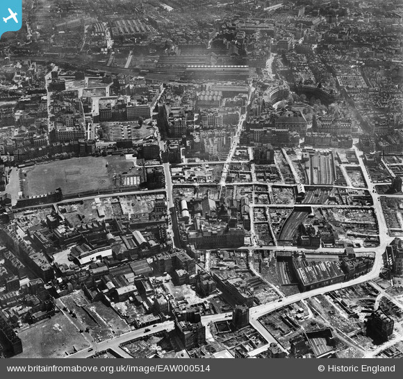
EAW000514 ENGLAND (1946). Bomb damage and clearance around Moorgate Street Station, the Artillery Ground and environs, London, 1946
    © Hawlfraint cyfranwyr OpenStreetMap a thrwyddedwyd gan yr OpenStreetMap Foundation. 2025. Trwyddedir y gartograffeg fel CC BY-SA.
  
Delweddau cyfagos (9)
Manylion
| Pennawd | [EAW000514] Bomb damage and clearance around Moorgate Street Station, the Artillery Ground and environs, London, 1946 | 
| Cyfeirnod | EAW000514 | 
| Dyddiad | 9-May-1946 | 
| Dolen | |
| Enw lle | LONDON | 
| Plwyf | |
| Ardal | |
| Gwlad | ENGLAND | 
| Dwyreiniad / Gogleddiad | 532622, 181878 | 
| Hydred / Lledred | -0.088281426944497, 51.519749233078 | 
| Cyfeirnod Grid Cenedlaethol | TQ326819 | 
Pinnau
|  Two Brewers Public House |   brianbeckett | Saturday 16th of May 2020 08:34:29 AM | 
|  Whitecross Street |   brianbeckett | Friday 15th of May 2020 02:23:49 PM | 
|  Electra House |   brianbeckett | Friday 15th of May 2020 02:22:56 PM | 
|  London Wall | Class31 | Wednesday 6th of August 2014 03:50:08 PM | 
|  Bunhill Fields | Class31 | Wednesday 6th of August 2014 03:49:47 PM | 
|  Bunhill Row | Class31 | Wednesday 6th of August 2014 03:49:31 PM | 
|  Finsbury Circus | Class31 | Tuesday 13th of May 2014 03:21:11 PM | 
| Class31 | Tuesday 13th of May 2014 03:20:33 PM | |
|  Broad Street Railway Station | Class31 | Tuesday 13th of May 2014 03:18:20 PM | 
|  Moorgate Street Station | Class31 | Tuesday 13th of May 2014 03:17:52 PM | 
 
             
  ![[EAW000514] Bomb damage and clearance around Moorgate Street Station, the Artillery Ground and environs, London, 1946](http://britainfromabove.org.uk/sites/all/libraries/aerofilms-images/public/100x100/EAW/000/EAW000514.jpg) 
  
                                          ![[EAW011200] The New Artillery Ground and surrounding cleared sites following bomb damage, St Luke's, 1947](http://britainfromabove.org.uk/sites/all/libraries/aerofilms-images/public/100x100/EAW/011/EAW011200.jpg) 
 ![[EAW011124] Cleared sites around Ropemaker Street following bomb damage, St Luke's, 1947. This image has been produced from a print.](http://britainfromabove.org.uk/sites/all/libraries/aerofilms-images/public/100x100/EAW/011/EAW011124.jpg) 
 ![[EAW011201] Cleared areas around the Whitbread Breweries on Whitecross Street following bomb damage, St Luke's, 1947](http://britainfromabove.org.uk/sites/all/libraries/aerofilms-images/public/100x100/EAW/011/EAW011201.jpg) 
 ![[EPW053665] Finsbury Circus and Finsbury Square, Finsbury, 1937](http://britainfromabove.org.uk/sites/all/libraries/aerofilms-images/public/100x100/EPW/053/EPW053665.jpg) 
 ![[EAW011123] The New Artillery Ground and surrounding cleared sites following bomb damage, St Luke's, 1947. This image has been produced from a print.](http://britainfromabove.org.uk/sites/all/libraries/aerofilms-images/public/100x100/EAW/011/EAW011123.jpg) 
 ![[EAW000511] Bomb damage and clearance around Moorgate Street Station, London, 1946](http://britainfromabove.org.uk/sites/all/libraries/aerofilms-images/public/100x100/EAW/000/EAW000511.jpg) 
 ![[EAW000513] Bomb damage and clearance around Moorgate Street Station, London, 1946](http://britainfromabove.org.uk/sites/all/libraries/aerofilms-images/public/100x100/EAW/000/EAW000513.jpg) 
 ![[EAW011217] The New Artillery Ground and Finsbury Square, St Luke's, 1947](http://britainfromabove.org.uk/sites/all/libraries/aerofilms-images/public/100x100/EAW/011/EAW011217.jpg)