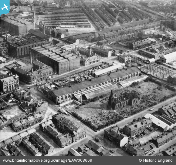
EAW008669 ENGLAND (1947). The Littlewoods Building on Irlam Road, the ruins of St Mary's Church and environs, Bootle, 1947
© Hawlfraint cyfranwyr OpenStreetMap a thrwyddedwyd gan yr OpenStreetMap Foundation. 2026. Trwyddedir y gartograffeg fel CC BY-SA.
Delweddau cyfagos (13)
Manylion
| Pennawd | [EAW008669] The Littlewoods Building on Irlam Road, the ruins of St Mary's Church and environs, Bootle, 1947 |
| Cyfeirnod | EAW008669 |
| Dyddiad | 1-August-1947 |
| Dolen | |
| Enw lle | BOOTLE |
| Plwyf | |
| Ardal | |
| Gwlad | ENGLAND |
| Dwyreiniad / Gogleddiad | 333653, 395270 |
| Hydred / Lledred | -2.9991486259231, 53.449753806394 |
| Cyfeirnod Grid Cenedlaethol | SJ337953 |
Pinnau

bob |
Saturday 17th of January 2026 07:51:53 AM | |

bob |
Thursday 14th of January 2021 01:06:21 PM | |

bob |
Thursday 27th of August 2020 05:28:27 PM | |

bob |
Tuesday 2nd of June 2020 05:02:02 PM | |

bob |
Tuesday 2nd of June 2020 05:01:38 PM | |

bob |
Tuesday 9th of July 2019 01:18:41 PM |


![[EAW008669] The Littlewoods Building on Irlam Road, the ruins of St Mary's Church and environs, Bootle, 1947](http://britainfromabove.org.uk/sites/all/libraries/aerofilms-images/public/100x100/EAW/008/EAW008669.jpg)
![[EAW008687] The Littlewoods Building on Irlam Road and environs, Bootle, 1947. This image was marked by Aerofilms Ltd for photo editing.](http://britainfromabove.org.uk/sites/all/libraries/aerofilms-images/public/100x100/EAW/008/EAW008687.jpg)
![[EAW008667] The Littlewoods Building on Irlam Road, the ruins of St Mary's Church and environs, Bootle, 1947](http://britainfromabove.org.uk/sites/all/libraries/aerofilms-images/public/100x100/EAW/008/EAW008667.jpg)
![[EAW008668] Strand Road, the Littlewoods Building on Irlam Road and environs, Bootle, 1947](http://britainfromabove.org.uk/sites/all/libraries/aerofilms-images/public/100x100/EAW/008/EAW008668.jpg)
![[EAW008670] The Littlewoods Building on Irlam Road, the ruins of St Mary's Church and environs, Bootle, 1947](http://britainfromabove.org.uk/sites/all/libraries/aerofilms-images/public/100x100/EAW/008/EAW008670.jpg)
![[EAW008671] The Littlewoods Building on Irlam Road, the ruins of St Mary's Church and environs, Bootle, 1947](http://britainfromabove.org.uk/sites/all/libraries/aerofilms-images/public/100x100/EAW/008/EAW008671.jpg)
![[EAW008681] Harland and Wolff Buildings on Strand Road, Alexandra Warehouse (No. 2) and environs, Bootle, 1947. This image was marked by Aerofilms Ltd for photo editing.](http://britainfromabove.org.uk/sites/all/libraries/aerofilms-images/public/100x100/EAW/008/EAW008681.jpg)
![[EAW008684] Harland and Wolff Buildings on Strand Road, Alexandra Warehouse (No. 2) and environs, Bootle, 1947. This image was marked by Aerofilms Ltd for photo editing.](http://britainfromabove.org.uk/sites/all/libraries/aerofilms-images/public/100x100/EAW/008/EAW008684.jpg)
![[EAW008672] Harland and Wolff Buildings on Strand Road, Alexandra Warehouse (No. 1) and environs, Bootle, 1947](http://britainfromabove.org.uk/sites/all/libraries/aerofilms-images/public/100x100/EAW/008/EAW008672.jpg)
![[EAW008688] Warehouses and industrial sites around Rimrose Road, Bootle, 1947. This image was marked by Aerofilms Ltd for photo editing.](http://britainfromabove.org.uk/sites/all/libraries/aerofilms-images/public/100x100/EAW/008/EAW008688.jpg)
![[EAW008683] Harland and Wolff Buildings on Strand Road, Alexandra Warehouse (No. 2) and environs, Bootle, 1947. This image was marked by Aerofilms Ltd for photo editing.](http://britainfromabove.org.uk/sites/all/libraries/aerofilms-images/public/100x100/EAW/008/EAW008683.jpg)
![[EAW008682] Harland and Wolff Buildings on Strand Road, Alexandra Warehouses (1 & 2) and environs, Bootle, 1947](http://britainfromabove.org.uk/sites/all/libraries/aerofilms-images/public/100x100/EAW/008/EAW008682.jpg)
![[EAW008678] Harland and Wolff Buildings on Strand Road, Alexandra Warehouse (No. 2) and environs, Bootle, 1947. This image was marked by Aerofilms Ltd for photo editing.](http://britainfromabove.org.uk/sites/all/libraries/aerofilms-images/public/100x100/EAW/008/EAW008678.jpg)