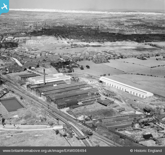
EAW008494 ENGLAND (1947). The Daniel Adamson and Co Engineering Works, Dukinfield, from the south, 1947. This image was marked by Aerofilms Ltd for photo editing.
© Hawlfraint cyfranwyr OpenStreetMap a thrwyddedwyd gan yr OpenStreetMap Foundation. 2026. Trwyddedir y gartograffeg fel CC BY-SA.
Delweddau cyfagos (32)
Manylion
| Pennawd | [EAW008494] The Daniel Adamson and Co Engineering Works, Dukinfield, from the south, 1947. This image was marked by Aerofilms Ltd for photo editing. |
| Cyfeirnod | EAW008494 |
| Dyddiad | 22-July-1947 |
| Dolen | |
| Enw lle | DUKINFIELD |
| Plwyf | |
| Ardal | |
| Gwlad | ENGLAND |
| Dwyreiniad / Gogleddiad | 394465, 396490 |
| Hydred / Lledred | -2.0833823877718, 53.464869770132 |
| Cyfeirnod Grid Cenedlaethol | SJ945965 |
Pinnau

Barney Rubble |
Friday 8th of April 2016 04:07:04 PM | |

Globe Lane Pals |
Monday 7th of July 2014 09:36:02 PM | |

Globe Lane Pals |
Monday 7th of July 2014 09:34:39 PM | |

Globe Lane Pals |
Monday 7th of July 2014 09:32:38 PM | |

Globe Lane Pals |
Monday 7th of July 2014 09:31:42 PM | |

Globe Lane Pals |
Monday 7th of July 2014 09:29:52 PM | |

Globe Lane Pals |
Monday 7th of July 2014 09:28:58 PM | |

Globe Lane Pals |
Monday 7th of July 2014 09:26:47 PM | |

Globe Lane Pals |
Monday 7th of July 2014 09:25:15 PM |


![[EAW008494] The Daniel Adamson and Co Engineering Works, Dukinfield, from the south, 1947. This image was marked by Aerofilms Ltd for photo editing.](http://britainfromabove.org.uk/sites/all/libraries/aerofilms-images/public/100x100/EAW/008/EAW008494.jpg)
![[EAW008497] The Daniel Adamson and Co Engineering Works, Dukinfield, from the south-west, 1947. This image was marked by Aerofilms Ltd for photo editing.](http://britainfromabove.org.uk/sites/all/libraries/aerofilms-images/public/100x100/EAW/008/EAW008497.jpg)
![[EAW008500] The Daniel Adamson and Co Engineering Works, Dukinfield, 1947. This image was marked by Aerofilms Ltd for photo editing.](http://britainfromabove.org.uk/sites/all/libraries/aerofilms-images/public/100x100/EAW/008/EAW008500.jpg)
![[EAW026620] The Daniel Adamson & Co Ltd Engineering Works and environs, Dukinfield, 1949. This image was marked by Aerofilms Ltd for photo editing.](http://britainfromabove.org.uk/sites/all/libraries/aerofilms-images/public/100x100/EAW/026/EAW026620.jpg)
![[EAW026617] The Daniel Adamson & Co Ltd Engineering Works and environs, Dukinfield, 1949. This image was marked by Aerofilms Ltd for photo editing.](http://britainfromabove.org.uk/sites/all/libraries/aerofilms-images/public/100x100/EAW/026/EAW026617.jpg)
![[EAW026619] The Daniel Adamson & Co Ltd Engineering Works and environs, Dukinfield, 1949. This image was marked by Aerofilms Ltd for photo editing.](http://britainfromabove.org.uk/sites/all/libraries/aerofilms-images/public/100x100/EAW/026/EAW026619.jpg)
![[EAW037548] The Daniel Adamson & Co Ltd Engineering Works, Dukinfield, 1951. This image has been produced from a print marked by Aerofilms Ltd for photo editing.](http://britainfromabove.org.uk/sites/all/libraries/aerofilms-images/public/100x100/EAW/037/EAW037548.jpg)
![[EAW052646] The Daniel Adamson and Co Ltd Engineering Works, Dukinfield, 1953. This image was marked by Aerofilms Ltd for photo editing.](http://britainfromabove.org.uk/sites/all/libraries/aerofilms-images/public/100x100/EAW/052/EAW052646.jpg)
![[EAW037552] The Daniel Adamson & Co Ltd Engineering Works, Dukinfield, 1951. This image has been produced from a print marked by Aerofilms Ltd for photo editing.](http://britainfromabove.org.uk/sites/all/libraries/aerofilms-images/public/100x100/EAW/037/EAW037552.jpg)
![[EAW026611] The Daniel Adamson & Co Ltd Engineering Works, Dukinfield, 1949. This image has been produced from a print marked by Aerofilms Ltd for photo editing.](http://britainfromabove.org.uk/sites/all/libraries/aerofilms-images/public/100x100/EAW/026/EAW026611.jpg)
![[EAW008495] The Daniel Adamson and Co Engineering Works, Dukinfield, from the south-west, 1947. This image was marked by Aerofilms Ltd for photo editing.](http://britainfromabove.org.uk/sites/all/libraries/aerofilms-images/public/100x100/EAW/008/EAW008495.jpg)
![[EAW026614] The Daniel Adamson & Co Ltd Engineering Works (site of), Dukinfield, 1949. This image has been produced from a damaged negative.](http://britainfromabove.org.uk/sites/all/libraries/aerofilms-images/public/100x100/EAW/026/EAW026614.jpg)
![[EAW008501] The Daniel Adamson and Co Engineering Works, Dukinfield, 1947. This image was marked by Aerofilms Ltd for photo editing.](http://britainfromabove.org.uk/sites/all/libraries/aerofilms-images/public/100x100/EAW/008/EAW008501.jpg)
![[EAW037544] The Daniel Adamson & Co Ltd Engineering Works, Dukinfield, 1951. This image has been produced from a print marked by Aerofilms Ltd for photo editing.](http://britainfromabove.org.uk/sites/all/libraries/aerofilms-images/public/100x100/EAW/037/EAW037544.jpg)
![[EAW026616] The Daniel Adamson & Co Ltd Engineering Works and environs, Dukinfield, 1949. This image was marked by Aerofilms Ltd for photo editing.](http://britainfromabove.org.uk/sites/all/libraries/aerofilms-images/public/100x100/EAW/026/EAW026616.jpg)
![[EAW026618] The Daniel Adamson & Co Ltd Engineering Works and environs, Dukinfield, 1949. This image was marked by Aerofilms Ltd for photo editing.](http://britainfromabove.org.uk/sites/all/libraries/aerofilms-images/public/100x100/EAW/026/EAW026618.jpg)
![[EAW008499] The Daniel Adamson and Co Engineering Works, Dukinfield, 1947. This image was marked by Aerofilms Ltd for photo editing.](http://britainfromabove.org.uk/sites/all/libraries/aerofilms-images/public/100x100/EAW/008/EAW008499.jpg)
![[EAW052648] The Daniel Adamson and Co Ltd Engineering Works, Dukinfield, 1953. This image was marked by Aerofilms Ltd for photo editing.](http://britainfromabove.org.uk/sites/all/libraries/aerofilms-images/public/100x100/EAW/052/EAW052648.jpg)
![[EAW037546] The Daniel Adamson & Co Ltd Engineering Works, Dukinfield, 1951. This image has been produced from a print marked by Aerofilms Ltd for photo editing.](http://britainfromabove.org.uk/sites/all/libraries/aerofilms-images/public/100x100/EAW/037/EAW037546.jpg)
![[EAW037550] The Daniel Adamson & Co Ltd Engineering Works, Dukinfield, 1951. This image has been produced from a print marked by Aerofilms Ltd for photo editing.](http://britainfromabove.org.uk/sites/all/libraries/aerofilms-images/public/100x100/EAW/037/EAW037550.jpg)
![[EAW037545] The Daniel Adamson & Co Ltd Engineering Works, Dukinfield, 1951. This image has been produced from a print marked by Aerofilms Ltd for photo editing.](http://britainfromabove.org.uk/sites/all/libraries/aerofilms-images/public/100x100/EAW/037/EAW037545.jpg)
![[EAW037547] The Daniel Adamson & Co Ltd Engineering Works, Dukinfield, 1951. This image has been produced from a print marked by Aerofilms Ltd for photo editing.](http://britainfromabove.org.uk/sites/all/libraries/aerofilms-images/public/100x100/EAW/037/EAW037547.jpg)
![[EAW037549] The Daniel Adamson & Co Ltd Engineering Works, Dukinfield, 1951. This image has been produced from a print marked by Aerofilms Ltd for photo editing.](http://britainfromabove.org.uk/sites/all/libraries/aerofilms-images/public/100x100/EAW/037/EAW037549.jpg)
![[EAW052647] The Daniel Adamson and Co Ltd Engineering Works, Dukinfield, 1953. This image was marked by Aerofilms Ltd for photo editing.](http://britainfromabove.org.uk/sites/all/libraries/aerofilms-images/public/100x100/EAW/052/EAW052647.jpg)
![[EAW052649] The Daniel Adamson and Co Ltd Engineering Works, Dukinfield, 1953. This image was marked by Aerofilms Ltd for photo editing.](http://britainfromabove.org.uk/sites/all/libraries/aerofilms-images/public/100x100/EAW/052/EAW052649.jpg)
![[EAW008498] The Daniel Adamson and Co Engineering Works, Dukinfield, 1947. This image was marked by Aerofilms Ltd for photo editing.](http://britainfromabove.org.uk/sites/all/libraries/aerofilms-images/public/100x100/EAW/008/EAW008498.jpg)
![[EAW026615] The Daniel Adamson & Co Ltd Engineering Works and environs, Dukinfield, 1949. This image has been produced from a damaged negative.](http://britainfromabove.org.uk/sites/all/libraries/aerofilms-images/public/100x100/EAW/026/EAW026615.jpg)
![[EAW037551] The Daniel Adamson & Co Ltd Engineering Works, Dukinfield, 1951. This image has been produced from a print marked by Aerofilms Ltd for photo editing.](http://britainfromabove.org.uk/sites/all/libraries/aerofilms-images/public/100x100/EAW/037/EAW037551.jpg)
![[EAW008502] The Daniel Adamson and Co Engineering Works, Dukinfield, 1947. This image was marked by Aerofilms Ltd for photo editing.](http://britainfromabove.org.uk/sites/all/libraries/aerofilms-images/public/100x100/EAW/008/EAW008502.jpg)
![[EAW037553] The Daniel Adamson & Co Ltd Engineering Works, Dukinfield, 1951. This image has been produced from a print marked by Aerofilms Ltd for photo editing.](http://britainfromabove.org.uk/sites/all/libraries/aerofilms-images/public/100x100/EAW/037/EAW037553.jpg)
![[EAW008496] The Daniel Adamson and Co Engineering Works, Dukinfield, from the north-west, 1947. This image was marked by Aerofilms Ltd for photo editing.](http://britainfromabove.org.uk/sites/all/libraries/aerofilms-images/public/100x100/EAW/008/EAW008496.jpg)
![[EAW052651] The Daniel Adamson and Co Ltd Engineering Works and environs, Dukinfield, 1953. This image was marked by Aerofilms Ltd for photo editing.](http://britainfromabove.org.uk/sites/all/libraries/aerofilms-images/public/100x100/EAW/052/EAW052651.jpg)