
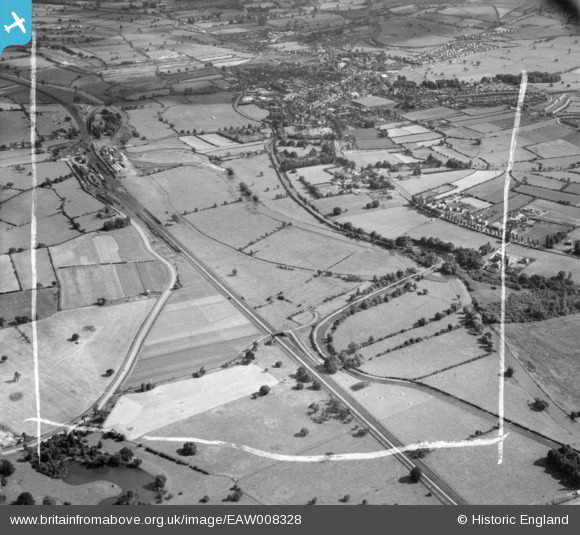
EAW008328 ENGLAND (1947). The River Trent and the Trent and Mersey Canal, Rugeley, from the north, 1947. This image was marked by Aerofilms Ltd for photo editing.
© Hawlfraint cyfranwyr OpenStreetMap a thrwyddedwyd gan yr OpenStreetMap Foundation. 2026. Trwyddedir y gartograffeg fel CC BY-SA.
Delweddau cyfagos (4)
EAW008328

EAW008322

EAW008327

EAW008330

Manylion
| Pennawd | [EAW008328] The River Trent and the Trent and Mersey Canal, Rugeley, from the north, 1947. This image was marked by Aerofilms Ltd for photo editing. |
| Cyfeirnod | EAW008328 |
| Dyddiad | 20-July-1947 |
| Dolen | |
| Enw lle | RUGELEY |
| Plwyf | RUGELEY |
| Ardal | |
| Gwlad | ENGLAND |
| Dwyreiniad / Gogleddiad | 404148, 319394 |
| Hydred / Lledred | -1.9385091569395, 52.771786916724 |
| Cyfeirnod Grid Cenedlaethol | SK041194 |
Pinnau

bescotbeast |
Monday 12th of May 2014 03:56:45 PM | |
|
bescotbeast |
Monday 12th of May 2014 03:51:21 PM | |
|
bescotbeast |
Monday 12th of May 2014 03:50:01 PM | |

MB |
Thursday 14th of November 2013 08:11:51 AM | |
|
MB |
Thursday 14th of November 2013 08:11:20 AM | |
|
MB |
Thursday 14th of November 2013 08:10:42 AM | |
|
MB |
Thursday 14th of November 2013 08:10:19 AM | |
|
MB |
Thursday 14th of November 2013 08:08:59 AM | |
|
MB |
Thursday 14th of November 2013 08:08:12 AM | |
|
MB |
Thursday 14th of November 2013 08:07:49 AM |