
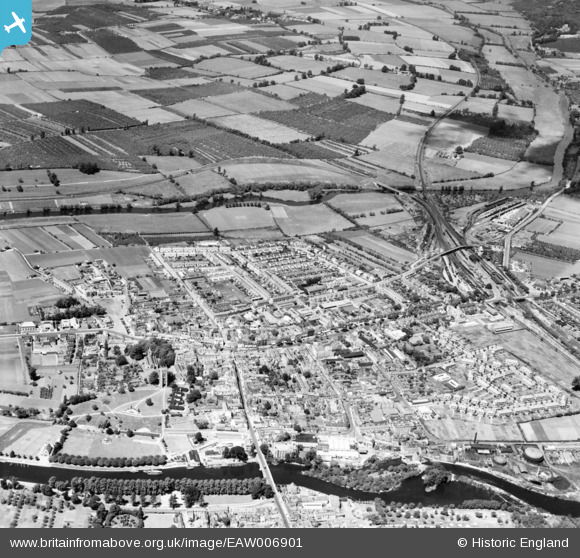
EAW006901 ENGLAND (1947). The town, Evesham, from the south-east, 1947
© Hawlfraint cyfranwyr OpenStreetMap a thrwyddedwyd gan yr OpenStreetMap Foundation. 2026. Trwyddedir y gartograffeg fel CC BY-SA.
Delweddau cyfagos (20)
EAW006901

EPW023909

EPW048026

EAW006900

EAW006898

EAW006899

EAW039998

EAW006892

EAW039997

EAW039992

EAW006891

EPW048025

EAW039995

EPW048082

EAW039994

EAW039996

EPW048024

EPW023911

EPW023906

EPW014619

Manylion
| Pennawd | [EAW006901] The town, Evesham, from the south-east, 1947 |
| Cyfeirnod | EAW006901 |
| Dyddiad | 10-June-1947 |
| Dolen | |
| Enw lle | EVESHAM |
| Plwyf | EVESHAM |
| Ardal | |
| Gwlad | ENGLAND |
| Dwyreiniad / Gogleddiad | 403766, 243925 |
| Hydred / Lledred | -1.9450228885767, 52.09324219803 |
| Cyfeirnod Grid Cenedlaethol | SP038439 |
Pinnau

DRS |
Monday 29th of June 2020 12:04:56 PM | |
|
DRS |
Monday 29th of June 2020 12:03:45 PM | |
|
DRS |
Monday 29th of June 2020 12:02:15 PM | |
|
DRS |
Monday 29th of June 2020 12:01:03 PM | |
|
DRS |
Monday 29th of June 2020 11:59:38 AM | |
|
DRS |
Monday 29th of June 2020 11:57:37 AM | |
|
DRS |
Monday 29th of June 2020 11:57:02 AM |