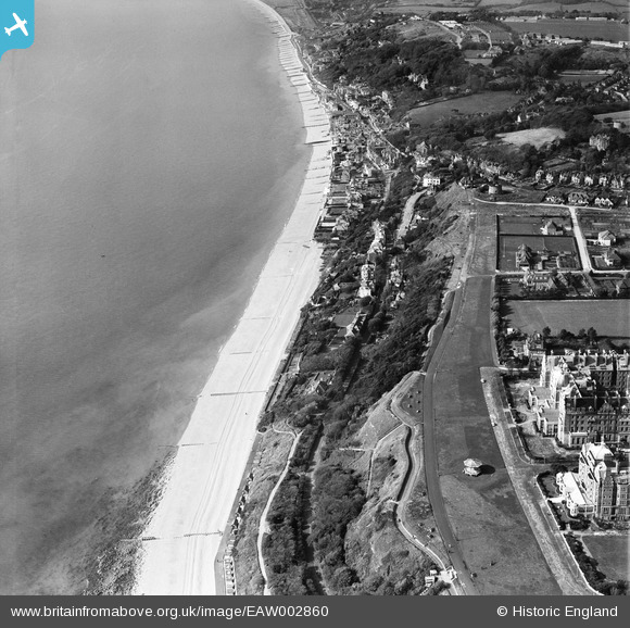
EAW002860 ENGLAND (1946). Radnor Cliff, the seafront and the village, Sandgate, 1946
    © Hawlfraint cyfranwyr OpenStreetMap a thrwyddedwyd gan yr OpenStreetMap Foundation. 2025. Trwyddedir y gartograffeg fel CC BY-SA.
  
Delweddau cyfagos (12)
Manylion
| Pennawd | [EAW002860] Radnor Cliff, the seafront and the village, Sandgate, 1946 | 
| Cyfeirnod | EAW002860 | 
| Dyddiad | 1-October-1946 | 
| Dolen | |
| Enw lle | SANDGATE | 
| Plwyf | SANDGATE | 
| Ardal | |
| Gwlad | ENGLAND | 
| Dwyreiniad / Gogleddiad | 621321, 135206 | 
| Hydred / Lledred | 1.1596788123386, 51.07290193339 | 
| Cyfeirnod Grid Cenedlaethol | TR213352 | 
 
             
  ![[EAW002860] Radnor Cliff, the seafront and the village, Sandgate, 1946](http://britainfromabove.org.uk/sites/all/libraries/aerofilms-images/public/100x100/EAW/002/EAW002860.jpg) 
  
                                          ![[EPW042871] Radnor Cliff, The Leas and the town, Folkestone, from the south-west, 1933](http://britainfromabove.org.uk/sites/all/libraries/aerofilms-images/public/100x100/EPW/042/EPW042871.jpg) 
 ![[EAW002859] The village and the seafront, Sandgate, 1946](http://britainfromabove.org.uk/sites/all/libraries/aerofilms-images/public/100x100/EAW/002/EAW002859.jpg) 
 ![[EAW002377] Sandgate Hill and environs, Folkestone, from the east, 1946](http://britainfromabove.org.uk/sites/all/libraries/aerofilms-images/public/100x100/EAW/002/EAW002377.jpg) 
 ![[EPW035412] Martello Tower number 4, Radnor Cliff and the town, Folkestone, from the west, 1931](http://britainfromabove.org.uk/sites/all/libraries/aerofilms-images/public/100x100/EPW/035/EPW035412.jpg) 
 ![[EAW032832] Martello Tower no. 4, Radnor Cliff Crescent and the seafront, Sandgate, from the east, 1950. This image was marked by Aerofilms Ltd for photo editing.](http://britainfromabove.org.uk/sites/all/libraries/aerofilms-images/public/100x100/EAW/032/EAW032832.jpg) 
 ![[EPW019045] Fair in progress off Dixwell Road, Folkestone, 1927. This image has been produced from a print.](http://britainfromabove.org.uk/sites/all/libraries/aerofilms-images/public/100x100/EPW/019/EPW019045.jpg) 
 ![[EAW002376] Sandgate Hill and environs, Folkestone, from the east, 1946](http://britainfromabove.org.uk/sites/all/libraries/aerofilms-images/public/100x100/EAW/002/EAW002376.jpg) 
 ![[EAW032836] Radnor Cliff Crescent, Martello Tower no. 4 and environs, Sandgate, from the south, 1950. This image was marked by Aerofilms Ltd for photo editing.](http://britainfromabove.org.uk/sites/all/libraries/aerofilms-images/public/100x100/EAW/032/EAW032836.jpg) 
 ![[EAW032835] Martello Tower no. 4 and The Leas, Folkestone, 1950](http://britainfromabove.org.uk/sites/all/libraries/aerofilms-images/public/100x100/EAW/032/EAW032835.jpg) 
 ![[EAW032834] Martello Tower no. 4 and The Leas looking towards the town and harbour, Folkestone, from the south-west, 1950](http://britainfromabove.org.uk/sites/all/libraries/aerofilms-images/public/100x100/EAW/032/EAW032834.jpg) 
 ![[EPW026116] Hotel Metropole and the Grand Hotel, Folkestone, 1929](http://britainfromabove.org.uk/sites/all/libraries/aerofilms-images/public/100x100/EPW/026/EPW026116.jpg) 
  Dragons' teeth anti-tank obstacles
 Dragons' teeth anti-tank obstacles