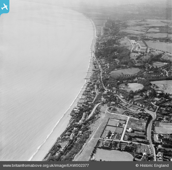
EAW002377 ENGLAND (1946). Sandgate Hill and environs, Folkestone, from the east, 1946
    © Hawlfraint cyfranwyr OpenStreetMap a thrwyddedwyd gan yr OpenStreetMap Foundation. 2025. Trwyddedir y gartograffeg fel CC BY-SA.
  
Delweddau cyfagos (14)
Manylion
| Pennawd | [EAW002377] Sandgate Hill and environs, Folkestone, from the east, 1946 | 
| Cyfeirnod | EAW002377 | 
| Dyddiad | 9-September-1946 | 
| Dolen | |
| Enw lle | FOLKESTONE | 
| Plwyf | FOLKESTONE | 
| Ardal | |
| Gwlad | ENGLAND | 
| Dwyreiniad / Gogleddiad | 621252, 135342 | 
| Hydred / Lledred | 1.1587785631369, 51.07414974732 | 
| Cyfeirnod Grid Cenedlaethol | TR213353 | 
Pinnau
|  2ndWW anti-tank ditch (filled in), e32133. |   redmist | Sunday 16th of February 2025 10:42:58 AM | 
|  Just visible is the infill for 2ndWW anti-tank rails. |   redmist | Sunday 16th of February 2025 10:41:50 AM | 
|  2ndWW anti-tank ditch, e32132. |   redmist | Sunday 16th of February 2025 10:40:57 AM | 
|  Just visible is the infill for 2ndWW anti-tank rails, e32135. |   redmist | Sunday 16th of February 2025 10:39:50 AM | 
 
             
  ![[EAW002377] Sandgate Hill and environs, Folkestone, from the east, 1946](http://britainfromabove.org.uk/sites/all/libraries/aerofilms-images/public/100x100/EAW/002/EAW002377.jpg) 
  
                                          ![[EPW035412] Martello Tower number 4, Radnor Cliff and the town, Folkestone, from the west, 1931](http://britainfromabove.org.uk/sites/all/libraries/aerofilms-images/public/100x100/EPW/035/EPW035412.jpg) 
 ![[EAW002376] Sandgate Hill and environs, Folkestone, from the east, 1946](http://britainfromabove.org.uk/sites/all/libraries/aerofilms-images/public/100x100/EAW/002/EAW002376.jpg) 
 ![[EPW019045] Fair in progress off Dixwell Road, Folkestone, 1927. This image has been produced from a print.](http://britainfromabove.org.uk/sites/all/libraries/aerofilms-images/public/100x100/EPW/019/EPW019045.jpg) 
 ![[EAW032832] Martello Tower no. 4, Radnor Cliff Crescent and the seafront, Sandgate, from the east, 1950. This image was marked by Aerofilms Ltd for photo editing.](http://britainfromabove.org.uk/sites/all/libraries/aerofilms-images/public/100x100/EAW/032/EAW032832.jpg) 
 ![[EPW026113] Sandgate Hill and Balfour Gardens, Folkestone, 1929](http://britainfromabove.org.uk/sites/all/libraries/aerofilms-images/public/100x100/EPW/026/EPW026113.jpg) 
 ![[EAW002860] Radnor Cliff, the seafront and the village, Sandgate, 1946](http://britainfromabove.org.uk/sites/all/libraries/aerofilms-images/public/100x100/EAW/002/EAW002860.jpg) 
 ![[EAW032835] Martello Tower no. 4 and The Leas, Folkestone, 1950](http://britainfromabove.org.uk/sites/all/libraries/aerofilms-images/public/100x100/EAW/032/EAW032835.jpg) 
 ![[EAW032834] Martello Tower no. 4 and The Leas looking towards the town and harbour, Folkestone, from the south-west, 1950](http://britainfromabove.org.uk/sites/all/libraries/aerofilms-images/public/100x100/EAW/032/EAW032834.jpg) 
 ![[EAW032836] Radnor Cliff Crescent, Martello Tower no. 4 and environs, Sandgate, from the south, 1950. This image was marked by Aerofilms Ltd for photo editing.](http://britainfromabove.org.uk/sites/all/libraries/aerofilms-images/public/100x100/EAW/032/EAW032836.jpg) 
 ![[EPW042871] Radnor Cliff, The Leas and the town, Folkestone, from the south-west, 1933](http://britainfromabove.org.uk/sites/all/libraries/aerofilms-images/public/100x100/EPW/042/EPW042871.jpg) 
 ![[EAW032833] Martello Tower no. 4, Radnor Cliff Crescent and environs, Folkestone, 1950. This image was marked by Aerofilms Ltd for photo editing.](http://britainfromabove.org.uk/sites/all/libraries/aerofilms-images/public/100x100/EAW/032/EAW032833.jpg) 
 ![[EAW002859] The village and the seafront, Sandgate, 1946](http://britainfromabove.org.uk/sites/all/libraries/aerofilms-images/public/100x100/EAW/002/EAW002859.jpg) 
 ![[EAW002858] The village and the seafront, Sandgate, 1946](http://britainfromabove.org.uk/sites/all/libraries/aerofilms-images/public/100x100/EAW/002/EAW002858.jpg)