
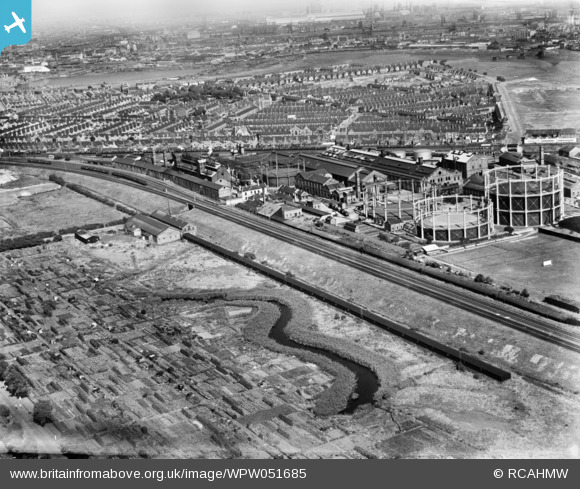
WPW051685 WALES (1936). View of Dixon's Ropeworks, Grangetown, oblique aerial view. 5"x4" black and white glass plate negative.
© Copyright OpenStreetMap contributors and licensed by the OpenStreetMap Foundation. 2026. Cartography is licensed as CC BY-SA.
Nearby Images (14)
WAW015094

WAW015095

WAW015096

WAW015097

WAW015098

WAW015099

WAW015100

WPW051681

WPW051682

WPW051683

WPW051684

WPW051685

WPW051686

WPW051687

Details
| Title | [WPW051685] View of Dixon's Ropeworks, Grangetown, oblique aerial view. 5"x4" black and white glass plate negative. |
| Reference | WPW051685 |
| Date | 1936 |
| Link | Coflein Archive Item 6370020 |
| Place name | |
| Parish | |
| District | |
| Country | WALES |
| Easting / Northing | 317315, 174459 |
| Longitude / Latitude | -3.1903664291925, 51.46256940301 |
| National Grid Reference | ST173745 |
Pins

gerry-r |
Friday 11th of July 2014 11:37:03 PM | |
|
Chelsea61 |
Monday 7th of April 2014 06:39:06 PM | |
|
AndrewF |
Monday 2nd of July 2012 09:45:53 PM | |
|
AndrewF |
Monday 2nd of July 2012 09:44:42 PM |
User Comment Contributions
The Community should not be shown as Gabalfa - it should either be Leckwith or Grangetown. |
Baramenyn |
Monday 7th of April 2014 06:44:59 PM |
Agree AS you can see St Paul's Church Grangetown in the middle of the frame |
Chelsea61 |
Monday 7th of April 2014 06:44:59 PM |
This is Grangetown which is Sw of City Centre as opposed to Gabalfa which is North of City Centre |
Chelsea61 |
Monday 7th of April 2014 06:42:39 PM |