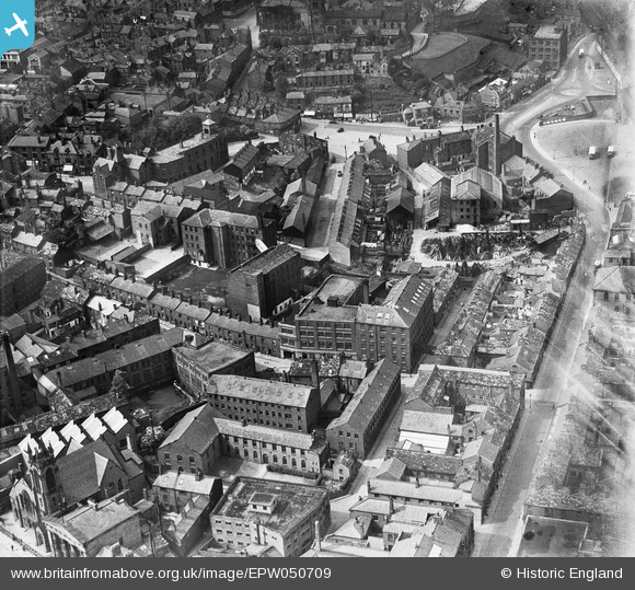
EPW050709 ENGLAND (1936). The Finishing Mill (Silk), the Marlborough Mill and the John Clayton Ltd Timber Yard, Macclesfield, 1936. This image has been affected by flare.
© Copyright OpenStreetMap contributors and licensed by the OpenStreetMap Foundation. 2026. Cartography is licensed as CC BY-SA.
Nearby Images (17)
Details
| Title | [EPW050709] The Finishing Mill (Silk), the Marlborough Mill and the John Clayton Ltd Timber Yard, Macclesfield, 1936. This image has been affected by flare. |
| Reference | EPW050709 |
| Date | June-1936 |
| Link | |
| Place name | MACCLESFIELD |
| Parish | |
| District | |
| Country | ENGLAND |
| Easting / Northing | 391842, 373470 |
| Longitude / Latitude | -2.1223026853115, 53.257893916525 |
| National Grid Reference | SJ918735 |
Pins

Tony Carter |
Thursday 13th of November 2014 06:49:30 AM | |

Tony Carter |
Thursday 13th of November 2014 06:48:15 AM | |

jonnyhud |
Wednesday 6th of November 2013 07:41:31 AM | |

jonnyhud |
Wednesday 6th of November 2013 07:40:24 AM | |

jonnyhud |
Wednesday 6th of November 2013 07:37:30 AM |


![[EPW050709] The Finishing Mill (Silk), the Marlborough Mill and the John Clayton Ltd Timber Yard, Macclesfield, 1936. This image has been affected by flare.](http://britainfromabove.org.uk/sites/all/libraries/aerofilms-images/public/100x100/EPW/050/EPW050709.jpg)
![[EPW050707] The Finishing Mill (Silk), the Marlborough Mill and the John Clayton Ltd Timber Yard, Macclesfield, 1936](http://britainfromabove.org.uk/sites/all/libraries/aerofilms-images/public/100x100/EPW/050/EPW050707.jpg)
![[EPW054379] The Railway Station, Waters Green and the town centre, Macclesfield, 1937](http://britainfromabove.org.uk/sites/all/libraries/aerofilms-images/public/100x100/EPW/054/EPW054379.jpg)
![[EPW050706] The Finishing Mill (Silk), the Marlborough Mill and the John Clayton Ltd Timber Yard, Macclesfield, 1936](http://britainfromabove.org.uk/sites/all/libraries/aerofilms-images/public/100x100/EPW/050/EPW050706.jpg)
![[EPW057641] Oxford Street, Boden Street and environs, Macclesfield, 1938](http://britainfromabove.org.uk/sites/all/libraries/aerofilms-images/public/100x100/EPW/057/EPW057641.jpg)
![[EPW050708] The Finishing Mill (Silk), the Marlborough Mill and the John Clayton Ltd Timber Yard, Macclesfield, 1936](http://britainfromabove.org.uk/sites/all/libraries/aerofilms-images/public/100x100/EPW/050/EPW050708.jpg)
![[EPW057635] Central Station, Sunderland Street and environs, Macclesfield, 1938](http://britainfromabove.org.uk/sites/all/libraries/aerofilms-images/public/100x100/EPW/057/EPW057635.jpg)
![[EPW016745] Park Green and environs, Macclesfield, 1926](http://britainfromabove.org.uk/sites/all/libraries/aerofilms-images/public/100x100/EPW/016/EPW016745.jpg)
![[EPW054374] Mill Street and the town centre, Macclesfield, 1937. This image has been produced from a copy-negative.](http://britainfromabove.org.uk/sites/all/libraries/aerofilms-images/public/100x100/EPW/054/EPW054374.jpg)
![[EPW057374] St Michael's Church, Mill Street and the town centre, Macclesfield, 1938](http://britainfromabove.org.uk/sites/all/libraries/aerofilms-images/public/100x100/EPW/057/EPW057374.jpg)
![[EPW054380] Mill Street and the town centre, Macclesfield, 1937](http://britainfromabove.org.uk/sites/all/libraries/aerofilms-images/public/100x100/EPW/054/EPW054380.jpg)
![[EPW016741] Park Green, Macclesfield, 1926](http://britainfromabove.org.uk/sites/all/libraries/aerofilms-images/public/100x100/EPW/016/EPW016741.jpg)
![[EPW054376] The town centre, Macclesfield, 1937](http://britainfromabove.org.uk/sites/all/libraries/aerofilms-images/public/100x100/EPW/054/EPW054376.jpg)
![[EPW057639] The town centre, Macclesfield, 1938. This image has been produced from a damaged negative.](http://britainfromabove.org.uk/sites/all/libraries/aerofilms-images/public/100x100/EPW/057/EPW057639.jpg)
![[EPW057643] Park Lane and surrounding streets, Macclesfield, 1938](http://britainfromabove.org.uk/sites/all/libraries/aerofilms-images/public/100x100/EPW/057/EPW057643.jpg)
![[EPW054378] Castle Street, St Michael's Church and the town centre, Macclesfield, 1937](http://britainfromabove.org.uk/sites/all/libraries/aerofilms-images/public/100x100/EPW/054/EPW054378.jpg)
![[EPW016737] The town centre, Macclesfield, 1926. This image has been produced from a damaged copy-negative.](http://britainfromabove.org.uk/sites/all/libraries/aerofilms-images/public/100x100/EPW/016/EPW016737.jpg)