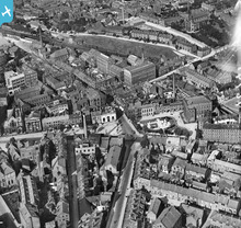
EPW016741 ENGLAND (1926). Park Green, Macclesfield, 1926
© Copyright OpenStreetMap contributors and licensed by the OpenStreetMap Foundation. 2026. Cartography is licensed as CC BY-SA.
Nearby Images (22)
Details
| Title | [EPW016741] Park Green, Macclesfield, 1926 |
| Reference | EPW016741 |
| Date | 28-August-1926 |
| Link | |
| Place name | MACCLESFIELD |
| Parish | |
| District | |
| Country | ENGLAND |
| Easting / Northing | 391915, 373274 |
| Longitude / Latitude | -2.1212033094356, 53.256133031609 |
| National Grid Reference | SJ919733 |
Pins

Steve T |
Friday 12th of September 2025 08:56:05 PM | |

jonnyhud |
Friday 25th of March 2016 12:39:39 PM | |

jonnyhud |
Friday 25th of March 2016 12:34:57 PM | |

jonnyhud |
Friday 25th of March 2016 12:31:29 PM | |

jonnyhud |
Friday 18th of March 2016 07:54:32 PM | |

jonnyhud |
Tuesday 1st of March 2016 08:31:45 PM | |

jonnyhud |
Tuesday 1st of March 2016 08:25:54 PM | |

jonnyhud |
Tuesday 1st of March 2016 08:24:55 PM | |

jonnyhud |
Tuesday 1st of March 2016 08:23:43 PM | |

jonnyhud |
Tuesday 1st of March 2016 08:17:55 PM | |

jonnyhud |
Sunday 31st of January 2016 08:31:39 PM | |

bescotbeast |
Wednesday 24th of September 2014 03:46:01 PM | |

bescotbeast |
Wednesday 24th of September 2014 03:43:39 PM | |

Ian |
Thursday 14th of August 2014 10:38:25 PM | |

janbo |
Wednesday 4th of December 2013 05:32:07 PM | |

PW |
Wednesday 2nd of October 2013 06:27:55 PM | |

Steve Gregory |
Monday 21st of January 2013 09:24:58 PM |
User Comment Contributions

bescotbeast |
Wednesday 24th of September 2014 03:47:51 PM | |
Fantastic quality,considering its from 1926 |

jonnyhud |
Monday 4th of November 2013 09:17:19 PM |


![[EPW016741] Park Green, Macclesfield, 1926](http://britainfromabove.org.uk/sites/all/libraries/aerofilms-images/public/100x100/EPW/016/EPW016741.jpg)
![[EAW018063] WM Frost and Sons Park Green Mill and environs, Macclesfield, 1948. This image has been produced from a print marked by Aerofilms Ltd for photo editing.](http://britainfromabove.org.uk/sites/all/libraries/aerofilms-images/public/100x100/EAW/018/EAW018063.jpg)
![[EAW018061] WM Frost and Sons Park Green Mill and environs, Macclesfield, 1948. This image has been produced from a print marked by Aerofilms Ltd for photo editing.](http://britainfromabove.org.uk/sites/all/libraries/aerofilms-images/public/100x100/EAW/018/EAW018061.jpg)
![[EAW018057] WM Frost and Sons Park Green Mill and environs, Macclesfield, 1948. This image was marked by Aerofilms Ltd for photo editing.](http://britainfromabove.org.uk/sites/all/libraries/aerofilms-images/public/100x100/EAW/018/EAW018057.jpg)
![[EAW018059] WM Frost and Sons Park Green Mill, Macclesfield, 1948. This image was marked by Aerofilms Ltd for photo editing.](http://britainfromabove.org.uk/sites/all/libraries/aerofilms-images/public/100x100/EAW/018/EAW018059.jpg)
![[EPW016745] Park Green and environs, Macclesfield, 1926](http://britainfromabove.org.uk/sites/all/libraries/aerofilms-images/public/100x100/EPW/016/EPW016745.jpg)
![[EAW018060] WM Frost and Sons Park Green Mill, Macclesfield, 1948. This image has been produced from a print marked by Aerofilms Ltd for photo editing.](http://britainfromabove.org.uk/sites/all/libraries/aerofilms-images/public/100x100/EAW/018/EAW018060.jpg)
![[EAW018062] WM Frost and Sons Park Green Mill and environs, Macclesfield, 1948. This image has been produced from a print marked by Aerofilms Ltd for photo editing.](http://britainfromabove.org.uk/sites/all/libraries/aerofilms-images/public/100x100/EAW/018/EAW018062.jpg)
![[EAW018058] WM Frost and Sons Park Green Mill, Macclesfield, 1948. This image was marked by Aerofilms Ltd for photo editing.](http://britainfromabove.org.uk/sites/all/libraries/aerofilms-images/public/100x100/EAW/018/EAW018058.jpg)
![[EPW057643] Park Lane and surrounding streets, Macclesfield, 1938](http://britainfromabove.org.uk/sites/all/libraries/aerofilms-images/public/100x100/EPW/057/EPW057643.jpg)
![[EPW050708] The Finishing Mill (Silk), the Marlborough Mill and the John Clayton Ltd Timber Yard, Macclesfield, 1936](http://britainfromabove.org.uk/sites/all/libraries/aerofilms-images/public/100x100/EPW/050/EPW050708.jpg)
![[EPW050706] The Finishing Mill (Silk), the Marlborough Mill and the John Clayton Ltd Timber Yard, Macclesfield, 1936](http://britainfromabove.org.uk/sites/all/libraries/aerofilms-images/public/100x100/EPW/050/EPW050706.jpg)
![[EPW050707] The Finishing Mill (Silk), the Marlborough Mill and the John Clayton Ltd Timber Yard, Macclesfield, 1936](http://britainfromabove.org.uk/sites/all/libraries/aerofilms-images/public/100x100/EPW/050/EPW050707.jpg)
![[EPW057635] Central Station, Sunderland Street and environs, Macclesfield, 1938](http://britainfromabove.org.uk/sites/all/libraries/aerofilms-images/public/100x100/EPW/057/EPW057635.jpg)
![[EPW050709] The Finishing Mill (Silk), the Marlborough Mill and the John Clayton Ltd Timber Yard, Macclesfield, 1936. This image has been affected by flare.](http://britainfromabove.org.uk/sites/all/libraries/aerofilms-images/public/100x100/EPW/050/EPW050709.jpg)
![[EPW057641] Oxford Street, Boden Street and environs, Macclesfield, 1938](http://britainfromabove.org.uk/sites/all/libraries/aerofilms-images/public/100x100/EPW/057/EPW057641.jpg)
![[EPW050698] Waterside and environs, Macclesfield, 1936. This image has been produced from a copy-negative.](http://britainfromabove.org.uk/sites/all/libraries/aerofilms-images/public/100x100/EPW/050/EPW050698.jpg)
![[EPW054376] The town centre, Macclesfield, 1937](http://britainfromabove.org.uk/sites/all/libraries/aerofilms-images/public/100x100/EPW/054/EPW054376.jpg)
![[EPW054379] The Railway Station, Waters Green and the town centre, Macclesfield, 1937](http://britainfromabove.org.uk/sites/all/libraries/aerofilms-images/public/100x100/EPW/054/EPW054379.jpg)
![[EPW050699] Waterside and environs, Macclesfield, 1936. This image has been produced from a copy-negative.](http://britainfromabove.org.uk/sites/all/libraries/aerofilms-images/public/100x100/EPW/050/EPW050699.jpg)
![[EPW054374] Mill Street and the town centre, Macclesfield, 1937. This image has been produced from a copy-negative.](http://britainfromabove.org.uk/sites/all/libraries/aerofilms-images/public/100x100/EPW/054/EPW054374.jpg)
![[EPW057374] St Michael's Church, Mill Street and the town centre, Macclesfield, 1938](http://britainfromabove.org.uk/sites/all/libraries/aerofilms-images/public/100x100/EPW/057/EPW057374.jpg)


